Date of Hike: Friday, July 11, 2014
Total Distance: 1.78 Miles
Avg Speed: 0.93 MPH
Avg Moving Speed: 1.55 MPH
Moving Time: 1:09:12
Total Time: 1:54:52
Conditions: Sunny, 85 Degrees
Difficulty: Easy to Moderate
As I mentioned in a previous post about Haycock Mountain, it was my intention to explore some areas I had found by looking at it through Google Earth/Maps. On Friday, I returned not only to explore some of those areas but also to find some more places to park since it's a pretty large area (approximately 2000 acres) and some additional trail heads. I was able to find both.
Approximate Location:
Quakertown, PA 18951
On Stoney Garden Road, I found a decent sized parking lot. While listed as approximately 1938 Stoney Garden Road on Google Maps, there's a mailbox directly across the street that says 1984 so it seems it's not always as accurate as one might think. I also checked Mapquest and it returned relatively the same results. The best thing I can tell you would be to use the GPS coordinates or just plug in the address and when you get close, keep your eyes open for the parking lot. Be advised that Stoney Garden Road has a lot of potholes!
 |
| Stoney Garden Road Parking Lot |
When you pull into the parking lot, the trail head is to the back left side
 |
| Trail head in back left side of parking lot |
When I began my exploring, the trail was in pretty good condition although there were a few downed trees that I had to climb over. Be sure to stay on the trail as there is private property to your right for a distance as you're walking into the game lands.
 |
| Small stream crossing along the trail |
 |
| Stream crossing looking the other direction |
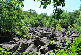
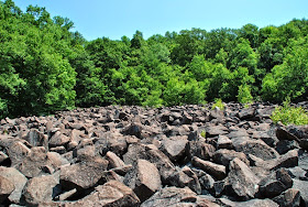
I'm not sure how far into the woods I was but finding my first objective was relatively easy. The trail leads to no more than about 30 yards away from the first "stoney garden". I guess this would explain the name of the street! I don't know if these rocks ring like they do at Ringing Rocks County Park but I would assume they do since I saw some hammer marks from people who were previously there. I did bring a hammer with me for the trip but decided to leave it in the car and just admire the view.
 |
| Some sort of fungus on the rocks |
More of this fungus on the rocks. Use caution when hopping around on the rocks if you see it. When you step on it, it crumbles under your feet and can make you slip and lose your footing.
 |
| It's hard to tell but this was the trail that led to the first rock garden |
After I left the first rock garden, I headed south to find the others and this was where it got fun. I'm not sure if there's a trail and if there is, I was unable to locate it and had to bushwhack my way through the woods to get there. It was at this point where I realized I had forgotten my compass. I had my phone which was tracking my progress and it helped me locate the other rock gardens but I think it might have been a little bit easier with the compass. I ended up straying to little too far to the west at first and had to readjust once I got my bearings.
Starting with the below picture, I panned from right to left and snapped off a total of four pictures to make a panoramic view of the entire garden. I plan to print them to make one large picture out of it.
It's hard to tell the but this was an opening between the two rock gardens that I was able to walk through.
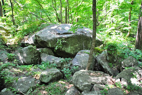
Once I was done in the rock gardens, I bushwhacked my way north through the woods until I located a trail again. I had crossed over one while trying to locate the other two rock gardens and was hoping to find that same trail which I did. Once I was on the trail, I continued east to see what else I could find and ran into another cluster of boulders.
As you might be able to tell from my tracks at the beginning of the post, I walked in a bit of a circle when I got to this area. For a short time, my phone lost its GPS signal and around that same time, I also lost the trail and was unable to locate it for a few minutes. Once again, my compass would have likely come in handy as you can't always rely on electronic devices to help you when you're in the middle of nowhere. When I found the trail again, I decided it was time to head back to the car for my next adventure to the Nockamixon Cliffs. In all, another great find and perhaps it can also be considered a hidden treasure as it doesn't seem many people may know about this place unless you're a hunter and I had it all to myself!
I'm nowhere near finished with exploring this mountain and will definitely be returning to continue my adventures. While I drove around the mountain, I found three other entrances with trail heads, all of which were on Haycock Run Road. Their approximate locations are:
898 Haycock Run Road
Haycock, PA
40.513921, -75.221045 or 40°30'50.1"N 75°13'15.8"W
There are two that are close together in this area:
1198 Haycock Run Road
Nockamixon, PA
40.513916, -75.221056 or 40°30'50.1"N 75°13'15.8"W
I didn't think to check for more entrances after I left but since I'll be returning, I'll make sure to look more closely next time. As I mentioned in the beginning of my post, Stoney Garden Road had a lot of potholes, especially as I continued further south so I had to keep my eyes on the road.
Happy exploring and happy hiking!
Please give my Facebook page a like!


Thanks for your blogs! We tried to find a trail on Haycock Mountain from the south near the lake, but it all looked like private property. I may follow up on your trail sometime and do a little hiking where you did, though likely not as deep in. Really beautiful pictures you've to here too.
ReplyDeleteYou're certainly welcome, thanks for stopping in! I'm glad you enjoyed the photos! From what I've read, there's supposed to be at least one parking lot on the southern end close to Nockamixon but I haven't located it myself. Since I moved out of Bucks County, I haven't returned to Haycock to finish my explorations...perhaps a return this coming spring may be in order!
DeleteThanks for sharing your adventure I plan on hiking to see the boulder fields this weekend!
ReplyDelete