Total Distance: 4.09 Miles
Avg Speed: 1.47MPH
Avg Moving Speed: 1.7MPH
Moving Time: 2:24:49
Total Time: 2:47:12
Conditions: Mostly Sunny, 85 degrees
Difficulty: Moderate, Difficult (once you get to the rocks)
While it's state games lands, Haycock Mountain which is just northwest of Nockamixon State Park, is listed on the Scenic Bucks County website as an attraction and rightly so. The below pictures don't do the rocks on this mountain any justice. What I saw was incredible and can say that this is one of those places where you have to see it in person to get a true idea of how awesome it is. If you've ever been to Niagara Falls, you'll know what I mean. You can look at thousands of pictures but it's nothing compared to seeing how beautiful it is for yourself.
The approximate address where I parked is:
325 Top Rock Road
Quakertown, PA 18951
GPS: 40.4924438, -75.2066597

When you get to the parking lot, you'll see a sign welcoming you to the property and also advising you to wear orange during hunting season. If you do not wish to wear it or don't have any orange clothing, it would be best to go on a Sunday or wait until hunting season is over. The hunting season calendar (titled Seasons & Bag Limits) can be found here.

I didn't get a picture but to the right of this sign, you'll see what looks like a dirt road leading up the hill. From what I've read, this road leads to basically nowhere but I can't confirm. I have plans to return here so I may eventually find out. Directly behind the sign is the trail head that leads you up the hill to the rocks.


The walk upwards isn't bad at all for the first part of the hike. As you work your way up the hill, you'll start to see rocks that gradually get larger and the trail starts to get more rocky. Make sure to wear some sturdy shoes. You'll also notice a few side trails leading to rocks on the right side of the trail. Apparently, there are also some trails that lead to different parts of the mountain as well, more on this later. While it does get difficult when you get to the rocks, the trail is hard to miss leading up to them.


 |
| Orange dot on rock is a trail marker. |


 |
| I have no idea what this is but it was on the ground on my way up the hill. |

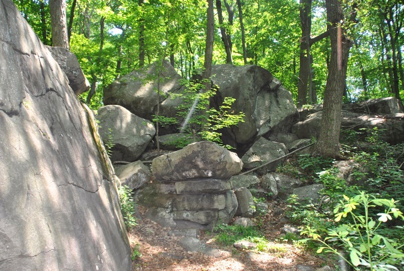
Once you get to the rocks, you'll notice that the trail is not well marked at all. There are trail markers but they're several different colors (black, blue, white, yellow, florescent orange) and some can be difficult to spot. If you use some sense and keep looking around, you'll find where the trail continues to the top of the mountain. If you can spot patches that are more worn than others (look for leaves that are relatively shredded from being trampled), you should be able to find your way. If you stay within the rocks on the way up, you'll be able to locate the trail on the other side once you get past them.


These next few shots are examples of pictures that simply don't do this place any justice. They're pointing up the mountain a good 50 or more yards to boulders that are much larger than cars and even trucks. I'll likely return here on a cloudy day so that the sun isn't shining to get some better pictures which will hopefully provide a better idea of the magnitude of this mountain. You will be climbing through these rocks to get to the top if you plan on following the trail. Use caution, this place is beautiful but dangerous


 |
| Purple-flowering Raspberry or Thimbleberry |


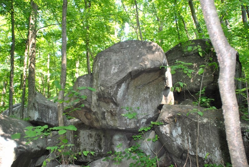
At this point, you're getting pretty close to the top of the mountain. As I already mentioned, be safe climbing up this hill, these boulders are large and rocks won't give if you fall on them.


At this point, you're pretty much at the peak of the mountain. If you want to keep going, the trail leading down the other side is very close.


Heading down the other side of the mountain, I didn't run into much until I was several hundred yards down the hill. At this point, I ran into some very thick growth which gave the appearance of walking through a tunnel. I think at this point, I only saw one trail marker throughout the rest of my hike until I circled back to the top of the mountain.


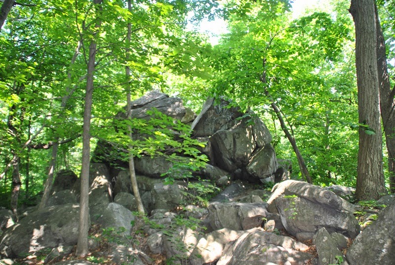
As you continue further down the trail, you'll run into another rock bed. It's not nearly as large as the top of the hill but it's worthy of spending a few minutes to take some pictures. I believe this section is called Area 51.


The trail on the other side of the mountain leads to a semi dirt/gravel road that leads to Saw Mill Road and a water tower.


 |
| Stream running over Saw Mill Road entrance |
 |
| Saw Mill Road entrance to roadway leading to water tower |


 |
| Back to the top of the mountain |

 |
| View looking down from the top of the mountain |
However, don't expect to find a decent trail map anywhere. While it's made for rock climbing, I found a guidebook that you can purchase from the Doylestown Rock Gym for $30 if it's still available (dated 2012). I also found a forum where you can obtain the guide for $25 as of the date it was posted (January 2012). I don't know if the email address is still valid or if the book is still available. The website is called Rockclimbing.com and the forum post can be found here. I found another website where it was being offered for $34.95 if my memory serves me right. If I can locate it again, I'll update this page. Apparently, Haycock is a pretty popular place for what's called bouldering.
There are some trail maps online but they don't provide much detail and leave a lot to the imagination. One is from the PA Climbing website called the Haycock Mountain Overview. There is also one other spot mentioned on the same website called Hangar 18. Here's another site that shows the locations of the climbing areas as well as their GPS locations when you click on the blue dots then the details links. There are supposed to be trails that lead to all of these places throughout the mountain but you're on your own other than the bit of info that's provided. I hope to eventually map this place myself but we'll see how it turns out.
There are also parking lots scattered around the outskirts of the mountain, some of which I've located and others I have yet to find. Another that I found is on Stony Garden Road. The approximate street address is:
1938 Stony Garden Road
Quakertown, PA 18951
GPS: 40.509955,-75.241102
After looking at Google Earth, I've also found some other places of interest that don't seem to be mentioned anywhere on the web. From what I've noticed, there seems to have been quite a few trees cleared for what looked to be logging but what interests me more is that there are a few rock gardens scattered throughout the mountain, three of which are relatively close together and a total of five throughout the game lands that I could see. Here are their locations according to Google Maps:
Rock Garden: 40.510889, -75.235293
Rock Garden: 40.506714, -75.236518
Rock Garden: 40.504645, -75.237738
Rock Garden: 40.503890, -75.238575
The gray spots to the right are the rock gardens and the Stony Garden Road parking lot isn't too far from there.
Update: I should have updated this post way sooner than I did. On July 11, 2014, I returned to Haycock Mountain to explore the rock gardens. When you arrive at the parking lot, there's a trail head in the back to the left side which will lead you to one of them.

Another on the other side of the game lands:
Rock Garden: 40.4823803,-75.2171259
A screenshot of this wouldn't really give you much to look at but as you'll be able to tell from the GPS location, it's on the opposite side of the mountain from the other rock gardens closer to Mountain View Drive (route 563)
Since exploring them, they look to be the same type of rocks that you'll find at Ringing Rocks County Park in Upper Black Eddy, PA. If you strike them with a hammer, they'll make a ringing noise like you're hitting a piece of metal pipe. Upon my return to Haycock Mountain to explore the rock gardens, I brought a hammer with me but I left it in the car.
Happy hiking and in this case, happy exploring!
why are they cutting all of the trees down there? I live right near this place and have so many great memories but I just went there and they have started cutting all of the trees down and continued to cut along the trail. its not just for making the trail wider its serious clearing going on! its looking like they are clearing for building to start.
ReplyDeleteI haven't been to Haycock since last year so I wasn't aware trees were being cut down. I may head over there to have a look now that you mention it. What I do know is that there has been tree clearing done there before (around 2009). If you look at Haycock Mountain on Google Maps Satellite View, you can see the areas that were previously cleared.
DeleteIt seems that it's part of a habitat management program run by the Pennsylvania Game Commission. From what I've found out, the different stages of forest growth (young, middle aged, and mature forests) support a more diverse range of wildlife compared to having a single stage of forest. It's not much but the information in the below link should provide at least a little bit of insight. For more information, perhaps the PA Game Commission could shed some additional light on this.
https://pagamecommission.wordpress.com/2015/01/
Thank you for the pictures and excellent description of the route you explored !! We've been through roughly 100 acres of Ringing Rocks Park, up and down the length of the stream bed, past the waterfalls (walking the stream bed is unbelievably more profound of an experience than the boulder field, by the way). We just found out about Haycock Mountain and we basically live right here on top of it, lol. Gonna check it out tomorrow, thanks for the guide! If you ever wanna join us for a hike, my wife and I go frequently, and have found some great places!
ReplyDeleteCheers
Hi RangerRick, you're welcome! I've been to Ringing Rocks a few times but it was before I started my blog so it wasn't documented like the many adventures I've taken since. Awesome place and one of the few in the Southeast PA area where you'll actually find waterfalls that aren't man made. Fantastic place and like you, I prefer the stream bed over the rock garden.
DeleteIf you get a chance while visiting Haycock Mountain, check out the rock gardens there as well. One of them you should be able to get to with ease but the others don't have trails leading to them as far as I could see. Enjoy your adventure and thanks for the offer! I'm always up for exploring new places!
Thanks for this blog. I want to go here but am nervous to go alone as I have read many reviews about people getting lost. Let me know if you are planning on returning here anytime this fall and I'll join!
ReplyDeleteHi JaimeSmiles, if you're looking to check out the boulders on the top of the hill, it's pretty much a straight shot from the parking lot on Top Rock Road. The trail does get a little bit confusing once you reach the boulders but if you keep going straight up the hill, you shouldn't have any trouble with getting lost.
DeleteUnfortunately, I now live in Chester County so getting to Haycock Mountain is a bit of a drive for me and I don't think I'll be making it up there this fall. It was much easier getting there when I lived in Bucks! I'll let you know if I make it up that way though.