Date of Hike: Monday, January 18, 2016
Total Distance: 6.19 Miles
Avg speed: 2.2 MPH
Total Time: 2:27:15
Conditions: Sunny, 21 Degrees
Difficulty: Easy, Moderate
This post is long overdue but alas, here it is. On January 18th, I took a ride out to the Wissahickon Valley Park to explore some of the trails in the northern section. It was a chilly morning to say the least and although the temperature was said to be 21 degrees that day, it surely felt like it was colder than that.
Unfortunately, digging up the history of this area turned out to be more difficult than I expected. The Friends of the Wissahickon website looks to have been recently updated which made many searches for the locations throughout the park difficult to research without getting an error saying the page in question no longer existed. If and when I find more information, I'll update this post accordingly.
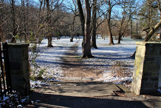
I parked in the East Bells Mill Road parking lot on the eastern side of the Wissahickon Creek to start my adventure. The approximate address is:
42 West Bells Mill Road
Philadelphia, PA 19118
GPS: 40.079393, -75.225085
As usual, the street address will get you close to the parking lot but it isn't exact. If you're approaching from the east, you'll want to keep going past the above address and the parking lot will be on your right. If you're approaching from the west, the parking lot will be to your left right after you cross over the Wissahickon Creek.

Trail maps are not provided at the kiosk stations. For a copy of the trail map, you'll have to purchase one from the Friends of the Wissahickon website ($10) or if you're at the park already, you may be able to purchase one at the Valley Green Inn. The last time I was there, you could purchase a map just outside the inn but with the updated FOW website, I cannot find any information stating they're still being sold there.
If you don't want to purchase a map or don't have one yet and want to explore the park, Google Maps has a layout of the trails which you can capture screenshots of and print. I bought a map the last time I was at the park but it's pretty large and having to mess with it on a windy day can be a problem and will eventually ruin it. With there being over 50 miles of trails, it would be best if you had something to bring along so you don't end up getting lost or turned around.

Before starting my adventure, I walked down to the edge of the creek to have a look and take a few pictures.

The trail head is in the back of the parking lot, you won't be able to miss it. To start, I headed in a northerly direction which eventually made a turn to the northwest. This is known as the Orange Trail.


Unlike the other sections of the Wissahickon Valley Park, there were few areas where the trail was rocky like what you see in the below picture. For the most part, the trails in this section of the park are relatively easy to traverse.


The Orange Trail eventually makes a turn to the east on its way towards Germantown Avenue.

As you approach Germantown Avenue, you'll see Chestnut Hill College. Originally founded by the Sisters of Saint Joseph and named Mount Saint Joseph College, it was opened in 1924 as a Catholic four year liberal arts college for women. In 1938, it was renamed to Chestnut Hill College.

As you approach Germantown Avenue, there's a walking bridge over the Wissahickon Creek.


Once you cross over the Wissahickon Creek, you'll see the trail on the opposite side heading in a southwest direction.
There were trail markers throughout the hike but not as many as I had hoped. You can see that there are two different markers on the tree below but I'm not sure if this trail is named or not.

Eventually, the unnamed trail (as far as I know) leads you alongside the Wissahickon Creek and over another small tributary.

This picnic shelter was the first one built at the Wissahickon Valley Park in 1936 and the meadow behind it was dedicated to William Warner Harper. Harper was the owner of the Andorra Nursery which at one time, was the largest tree nursery in the eastern half of the United States and consisted of 1,400 acres of land.


Once past the picnic shelter, I took a turn to the southeast heading down Forbidden Drive. Completed in 1853, Forbidden Drive used to be a turnpike with three toll booths. In 1874, it became Wissahickon Drive when the Fairmount Park Commission bought the surrounding land. In 1920, it was closed to vehicular traffic and was renamed to the name you hear today, Forbidden Drive.


Forbidden Drive runs alongside the Wissahickon Creek, this is the same area I took a picture of while I was on my way to Germantown Avenue from the parking lot.


As you get close to Bells Mill Road, there are trails leading to the west into the hills. To the left side of the below picture, you can see a small stone stairway leading to these trails.

This is known as the Green Trail and heads southwest before making a sharp turn to the north, then another sharp turn to the southwest again.


This intersection is a connecting trail where the Green Trail continues to the southwest and the connecting trail takes a turn to the northwest and was the direction I went. As usual, it was my intention to get in as much distance in as possible and with the number of trails in this section of the park, I planned my route before getting there.


The connecting trail takes a slight turn to the north before connecting with the Forest Loop trail.

Once the connecting trail intersects with the Forest Loop trail, it take another slight turn back to the northeast, then making another turn to the northwest.


In some areas, you can look down the hill through the trees to see the Wissahickon Creek and Forbidden Drive. This view is from the Forest Trail looking back to the southeast.It's hard to tell in the picture but if you look closely, you can see the wooden fence and Wissahickon Creek on the lower left side of this picture.

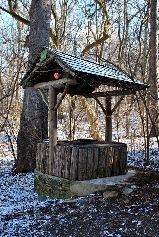
Always cool finding stuff like this in the middle of the woods!


I continued following the Forest Trail which eventually made another turn to the southwest where it intersected with the Teal Trail and made another turn to the east. A short distance down the Teal Trail, it intersects with the Blue Trail which will bring you back to the Forest Trail (confusing, isn't it?). Since I had already been there, I stayed on the Teal Trail which make a slight turn to the southeast.


Somewhere in this area, I took a "wrong turn". When hiking, there's really no such thing as a wrong turn but I managed to lose my sense of direction and took a trail that I hadn't planned on taking. At this intersection, I believe I was supposed to keep following the Teal Trail (left) but instead turned right onto the Gnome Trail (orange) heading southwest.


The Gnome Trail is a short one, maybe 1/4 mile at the most and it then intersects with the Yellow Trail continuing southwest.

In a way, I'm glad I took the wrong trail. I would have never seen this tree had I not made the "wrong turn". Known as the Great Beech, it's said to be the highest scoring beech in the state of Pennsylvania. For an explanation on how a tree is scored, click here and scroll down to page 7.


Shortly after passing the Great Beech, I realized my mistake and doubled back to the trails I had intended on exploring. I made my way back to the Teal Trail heading southeast.

The Teal Trail leads you back to the Forest Trail where I turned to the southwest.


The Forest Loop and Green Trails merge for a very short distance and from there, the merged trails intersect with the Meadow Loop which takes a slight turn to the south.


The Meadow Loop will bring you through what's known as Andorra Meadow.


These are known as the Black Farm Ruins. Unfortunately, there's not much to be found for what this place was at one time other than it being a farm.


The trail makes a gradual turn to the southwest, then turning again to the northwest.


The fenced in area was recently treated with a pesticide but for what reason, I'm not sure.

The meadow was very nice, especially with how blue the sky was that day.

In this area, the Meadow Loop makes a few turns back and forth, eventually towards the northeast running alongside West Northwestern Avenue.

Once you make your way back into the woods, the Meadow Loop takes another turn to the southeast.

A short distance down the Meadow Loop, the trail intersects with the Meadow Observation Loop which brings you back into Andorra Meadow

The Meadow Observation Loop is a short trail and as its name states, heads south, then loops north back to the Meadow Loop.

Once you're back into the woods, the Meadow Loop intersects with the Forest trail again and from there, you can turn to the southeast or northwest. Since I had already seen the trail to the southeast, I turned to the northwest.

After another turn to the northeast, you'll be hiking alongside West Northwestern Avenue and approaching the Wissahickon Environmental Center.

This is also the area where you'll find the parking lot for the environmental center. When I made my wrong turn, I ended up in the back of the parking lot and was where I noticed what I had done and turned back.

Somewhere in this area, the Forest Loop cuts to the southeast with a bike bypass path continuing to the northeast, I stayed on the Forest Loop since I wanted to check out the environmental center.

After making my turn to the northeast, I approached the Wissahickon Environmental Center, also known as the Tree House. In 1890, the Adolph Stenile who was the chief propagator of the Andorra Nursery, built a home next to a large sycamore tree. Instead of cutting the tree down, he built the porch around the tree and as his family grew, he enclosed the porch and sycamore tree to create a dining room. After the area became a nature preserve, the Tree House became the visitor center. The sycamore tree survived until 1981 when it was finally cut down.
Unfortunately, the visitor center was closed during my adventure so I was unable to see the sycamore tree, or at least what's left of it.


The below sign was posted on the above tree that has its branches reaching to the sides.


Once I was done checking out the Tree House, I was on my way back to the car. For the most part with a few quick changes of direction, I was headed to the northeast.


I made my way back to Forbidden Drive and the Cedars House Cafe which offers breakfast, lunch and snacks throughout the day. I didn't go inside and although you could see lights on, I wasn't sure if it was open. Perhaps when I return, I'll give this place a closer look.


Once I was done checking out the cafe, it was time to wrap up my hike. I returned to the trail running alongside the Wissahickon Creek that I had hiked when I first started my adventure.


Almost back to the parking lot, I took a picture of the Bells Mill Road bridge over the Wissahickon.

That was it for my adventure at the Wissahickon Valley Park for the day. In all, it was a fun adventure and one that I'd eventually like to return to. The park is enormous with over 50 miles of trails so there's still a lot more to explore. The condition of the trails were good and there were signs posted at just about every intersecting trail but I would have liked to have seen more trail markers throughout the hike to let me know I was headed in the right direction.
This post is long overdue but alas, here it is. On January 18th, I took a ride out to the Wissahickon Valley Park to explore some of the trails in the northern section. It was a chilly morning to say the least and although the temperature was said to be 21 degrees that day, it surely felt like it was colder than that.
Unfortunately, digging up the history of this area turned out to be more difficult than I expected. The Friends of the Wissahickon website looks to have been recently updated which made many searches for the locations throughout the park difficult to research without getting an error saying the page in question no longer existed. If and when I find more information, I'll update this post accordingly.
I parked in the East Bells Mill Road parking lot on the eastern side of the Wissahickon Creek to start my adventure. The approximate address is:
42 West Bells Mill Road
Philadelphia, PA 19118
GPS: 40.079393, -75.225085
As usual, the street address will get you close to the parking lot but it isn't exact. If you're approaching from the east, you'll want to keep going past the above address and the parking lot will be on your right. If you're approaching from the west, the parking lot will be to your left right after you cross over the Wissahickon Creek.

Trail maps are not provided at the kiosk stations. For a copy of the trail map, you'll have to purchase one from the Friends of the Wissahickon website ($10) or if you're at the park already, you may be able to purchase one at the Valley Green Inn. The last time I was there, you could purchase a map just outside the inn but with the updated FOW website, I cannot find any information stating they're still being sold there.
If you don't want to purchase a map or don't have one yet and want to explore the park, Google Maps has a layout of the trails which you can capture screenshots of and print. I bought a map the last time I was at the park but it's pretty large and having to mess with it on a windy day can be a problem and will eventually ruin it. With there being over 50 miles of trails, it would be best if you had something to bring along so you don't end up getting lost or turned around.

Before starting my adventure, I walked down to the edge of the creek to have a look and take a few pictures.

The trail head is in the back of the parking lot, you won't be able to miss it. To start, I headed in a northerly direction which eventually made a turn to the northwest. This is known as the Orange Trail.


Unlike the other sections of the Wissahickon Valley Park, there were few areas where the trail was rocky like what you see in the below picture. For the most part, the trails in this section of the park are relatively easy to traverse.

 |
| Looking upstream on the Wissahickon Creek from the Orange Trail |


 |
| Looking back in the direction of the parking lot |
The Orange Trail eventually makes a turn to the east on its way towards Germantown Avenue.

As you approach Germantown Avenue, you'll see Chestnut Hill College. Originally founded by the Sisters of Saint Joseph and named Mount Saint Joseph College, it was opened in 1924 as a Catholic four year liberal arts college for women. In 1938, it was renamed to Chestnut Hill College.

As you approach Germantown Avenue, there's a walking bridge over the Wissahickon Creek.


 |
| Looking downstream from the bridge over the Wissahickon Creek |
 |
| A better view of Chestnut Hill College |
Once you cross over the Wissahickon Creek, you'll see the trail on the opposite side heading in a southwest direction.

There were trail markers throughout the hike but not as many as I had hoped. You can see that there are two different markers on the tree below but I'm not sure if this trail is named or not.

 |
| Bat box! Pretty cool, I can't say I've ever seen a box built to house bats! |
Eventually, the unnamed trail (as far as I know) leads you alongside the Wissahickon Creek and over another small tributary.

This picnic shelter was the first one built at the Wissahickon Valley Park in 1936 and the meadow behind it was dedicated to William Warner Harper. Harper was the owner of the Andorra Nursery which at one time, was the largest tree nursery in the eastern half of the United States and consisted of 1,400 acres of land.


Once past the picnic shelter, I took a turn to the southeast heading down Forbidden Drive. Completed in 1853, Forbidden Drive used to be a turnpike with three toll booths. In 1874, it became Wissahickon Drive when the Fairmount Park Commission bought the surrounding land. In 1920, it was closed to vehicular traffic and was renamed to the name you hear today, Forbidden Drive.


Forbidden Drive runs alongside the Wissahickon Creek, this is the same area I took a picture of while I was on my way to Germantown Avenue from the parking lot.


 |
| Looking back to the north on Forbidden Drive |
As you get close to Bells Mill Road, there are trails leading to the west into the hills. To the left side of the below picture, you can see a small stone stairway leading to these trails.

 |
| Closer shot of the staircase |
 |
| One last look at Forbidden Drive and the Wissahickon Creek before heading into the hills. |
This is known as the Green Trail and heads southwest before making a sharp turn to the north, then another sharp turn to the southwest again.


This intersection is a connecting trail where the Green Trail continues to the southwest and the connecting trail takes a turn to the northwest and was the direction I went. As usual, it was my intention to get in as much distance in as possible and with the number of trails in this section of the park, I planned my route before getting there.


The connecting trail takes a slight turn to the north before connecting with the Forest Loop trail.

Once the connecting trail intersects with the Forest Loop trail, it take another slight turn back to the northeast, then making another turn to the northwest.


In some areas, you can look down the hill through the trees to see the Wissahickon Creek and Forbidden Drive. This view is from the Forest Trail looking back to the southeast.It's hard to tell in the picture but if you look closely, you can see the wooden fence and Wissahickon Creek on the lower left side of this picture.

Always cool finding stuff like this in the middle of the woods!


I continued following the Forest Trail which eventually made another turn to the southwest where it intersected with the Teal Trail and made another turn to the east. A short distance down the Teal Trail, it intersects with the Blue Trail which will bring you back to the Forest Trail (confusing, isn't it?). Since I had already been there, I stayed on the Teal Trail which make a slight turn to the southeast.


Somewhere in this area, I took a "wrong turn". When hiking, there's really no such thing as a wrong turn but I managed to lose my sense of direction and took a trail that I hadn't planned on taking. At this intersection, I believe I was supposed to keep following the Teal Trail (left) but instead turned right onto the Gnome Trail (orange) heading southwest.


The Gnome Trail is a short one, maybe 1/4 mile at the most and it then intersects with the Yellow Trail continuing southwest.

In a way, I'm glad I took the wrong trail. I would have never seen this tree had I not made the "wrong turn". Known as the Great Beech, it's said to be the highest scoring beech in the state of Pennsylvania. For an explanation on how a tree is scored, click here and scroll down to page 7.


Shortly after passing the Great Beech, I realized my mistake and doubled back to the trails I had intended on exploring. I made my way back to the Teal Trail heading southeast.

The Teal Trail leads you back to the Forest Trail where I turned to the southwest.

 |
| Forest Loop trail intersecting with the Yellow Trail, I continued on the Forest Loop trail |


The Forest Loop and Green Trails merge for a very short distance and from there, the merged trails intersect with the Meadow Loop which takes a slight turn to the south.


The Meadow Loop will bring you through what's known as Andorra Meadow.


These are known as the Black Farm Ruins. Unfortunately, there's not much to be found for what this place was at one time other than it being a farm.


The trail makes a gradual turn to the southwest, then turning again to the northwest.


The fenced in area was recently treated with a pesticide but for what reason, I'm not sure.

The meadow was very nice, especially with how blue the sky was that day.

 |
| Meadow Loop then making another turn to the west |
In this area, the Meadow Loop makes a few turns back and forth, eventually towards the northeast running alongside West Northwestern Avenue.

Once you make your way back into the woods, the Meadow Loop takes another turn to the southeast.

A short distance down the Meadow Loop, the trail intersects with the Meadow Observation Loop which brings you back into Andorra Meadow

The Meadow Observation Loop is a short trail and as its name states, heads south, then loops north back to the Meadow Loop.

Once you're back into the woods, the Meadow Loop intersects with the Forest trail again and from there, you can turn to the southeast or northwest. Since I had already seen the trail to the southeast, I turned to the northwest.

After another turn to the northeast, you'll be hiking alongside West Northwestern Avenue and approaching the Wissahickon Environmental Center.

This is also the area where you'll find the parking lot for the environmental center. When I made my wrong turn, I ended up in the back of the parking lot and was where I noticed what I had done and turned back.

Somewhere in this area, the Forest Loop cuts to the southeast with a bike bypass path continuing to the northeast, I stayed on the Forest Loop since I wanted to check out the environmental center.
 |
| Big cat hanging out close to the environmental center |
 |
| Another turn in the Forest Loop to the northeast |

After making my turn to the northeast, I approached the Wissahickon Environmental Center, also known as the Tree House. In 1890, the Adolph Stenile who was the chief propagator of the Andorra Nursery, built a home next to a large sycamore tree. Instead of cutting the tree down, he built the porch around the tree and as his family grew, he enclosed the porch and sycamore tree to create a dining room. After the area became a nature preserve, the Tree House became the visitor center. The sycamore tree survived until 1981 when it was finally cut down.
Unfortunately, the visitor center was closed during my adventure so I was unable to see the sycamore tree, or at least what's left of it.


The below sign was posted on the above tree that has its branches reaching to the sides.

 |
| Information about the Andorra Natural Area |
 |
| Map of the area I had hiked, located at the visitor center. |
 |
| Information about the Andorra Nursery |


Once I was done checking out the Tree House, I was on my way back to the car. For the most part with a few quick changes of direction, I was headed to the northeast.


I made my way back to Forbidden Drive and the Cedars House Cafe which offers breakfast, lunch and snacks throughout the day. I didn't go inside and although you could see lights on, I wasn't sure if it was open. Perhaps when I return, I'll give this place a closer look.

 |
| Information about Forbidden Drive |

Once I was done checking out the cafe, it was time to wrap up my hike. I returned to the trail running alongside the Wissahickon Creek that I had hiked when I first started my adventure.


Almost back to the parking lot, I took a picture of the Bells Mill Road bridge over the Wissahickon.

 |
| Back at the parking lot, I took one last picture of the bridge. |
That was it for my adventure at the Wissahickon Valley Park for the day. In all, it was a fun adventure and one that I'd eventually like to return to. The park is enormous with over 50 miles of trails so there's still a lot more to explore. The condition of the trails were good and there were signs posted at just about every intersecting trail but I would have liked to have seen more trail markers throughout the hike to let me know I was headed in the right direction.
just did virtually this same walk today, plus more. I lived here 40 years and explored all over the area. Never knew about the meadow or Black Farm Ruins. I was flabbergasted and my jaw dropped at the sight of the area. To be here this long, and all over those woods and miss that HUGE meadow. Amazing!
ReplyDeleteWissahickon Valley Park is amazing altogether! I haven't explored all of the trails but the ones I've seen have been incredible. I'm still amazed that such a beautiful place exists within the boundaries of Philadelphia. I look forward to returning to the park, it's been a while since I've been hiking due to an injury and having things to do around the home. I'm pretty much healed up now so once the work at home is completed, I'll be hitting the trails again! Thanks for stopping in!
Delete