Date of Hike: Saturday, June 13, 2015
Total Distance: 7.48 Miles
Avg speed: 2.65 MPH
Avg moving speed: 2.95 MPH
Moving Time: 2:32:11
Total Time: 2:49:28
Conditions: Sunny, 82 Degrees
Difficulty: Easy, Moderate, Difficult
This past Saturday, I took a ride out to Valley Forge National Historical Park to hike Mount Misery. Like my trip to Nockamixon State Park a few weeks ago, I hiked Mount Misery last year and had intended to post pictures from that hike but never got around to it. Instead, I decided to hike it again which didn't take much persuasion since it's a nice hike and mostly under the shade. The temperature was said to be in the low 80's but the humidity made up for the "lower" temperatures. It sure felt like it was warmer than 82 out there!
For this adventure and to add some distance to my hike, I parked in the parking lot next to the Washington Memorial Chapel. There's no official street address for the chapel but if you're driving on PA State Route 23 (Valley Forge Park Road), you won't be able to miss it. There are also numerous parking lots throughout the park (I counted 12) so if one is full which is rare, you can easily locate another.
If you park at the chapel instead of closer to Mount Misery, you'll need both the Chapel Trail and Mount Misery trail maps or you can get a map of the entire park if you don't mind how small it is. The map of the entire park is useful for finding all of the parking lots within the park. There are also information kiosks throughout the park where you can grab a map. If you're looking to explore a different section of the park and need a different map, click here.
Below is the approximate address. Apparently, Google Maps still thinks this is in King of Prussia! The best I can tell you would be to use the GPS coordinates and look for the parking lot as you get close. You won't miss it.
Valley Forge Park Rd
King of Prussia, PA 19406
GPS: 40.104374, -75.436480

In the back of the Washington Memorial Chapel parking lot is a trail head that will lead you south down a hill to the Chapel Trail.

The hill leading down to the Chapel Trail isn't too difficult. It was wet from recent rains but nothing too bad.

For the first leg of the journey, I didn't take too many pictures of the trail since I've already been on it. If you'd like to get a better look at the Chapel Trail, you can check out my post from when I hiked Mount Joy in early April.


While the colors can be a bit boring in the winter, here's a good reason to explore when it's cold and there aren't any leaves on the trees. Unless you know it's there, the ruins of this home are pretty well shrouded by the leaves and would be easy to miss. I tried getting closer to the ruins but this time around, I was wearing my shorts so I didn't venture in too far.

This is a picture of the ruins from when I was hiking the Chapel Trail in April 2015

This is the one steep hill on the Chapel Trail although it's small. Watch your step if it's wet though, it's easy to slip and there was water still streaming down both sides of the hill into the small creek at the bottom.


Almost at Washington's Headquarters, this is a view of Mount Misery where I'd soon be hiking.


Once past Washington's Headquarters, continue south and use the crosswalk to cross over PA State Route 23 (Valley Forge Park Road) and turn to the west. Note that this is a busy road and is also an intersection with PA State Route 252 (Valley Creek Road). Once you cross over, you'll see this plaque indicating the start of the Horse-Shoe Trail which is now 141 miles long.

View of Valley Creek from the bridge on PA State Route 23

Once you cross the bridge over Valley Creek, you'll see this white house and the signs for the Patriotic Order Sons of America and trail heads indicating the Valley Creek and Horse-Shoe Trails.


Follow the gravel driveway southwest past the Patriotic Order Sons of America building which will be on your left. You'll also be passing private property on your right.

I probably should have backed up and only taken a single picture but this is an unnamed trail intersecting with the Horse-Shoe Trail. Last year, I stayed on the Horse-Shoe Trail so this time around, I decided to explore the trail to Colonial Springs.


One of a few spots on the trail where it was in the open. It was pretty humid on Saturday so I made sure to pick a place to hike that would be mostly in the shade.


After a short distance, the unnamed trail circles back to the Horse-Shoe Trail and over this small stream.


Continuing southwest and a little further up the trail is the Colonial Springs Bottling Plant. I can't seem to locate much information on when it was built but what I did find is that in 1908, General B. J. Fisher granted a lease to the Colonial Springs Company to use the water of Cold Springs for bottling. In 1900, Fisher has also sold 5000 gallons of the water to C.T. Chase.
As usual, I went a little crazy with taking pictures of the ruins, I can't help it! If you want to see what the building looked like while it was still in operation, click here.


Once you pass the ruins of the bottling plant, the trail takes a sharp turn to the northeast, the turns again to the southeast. Through most of the hike, the trails (that aren't gravel) were in good condition minus the few soggy spots from the rain earlier in the week.


The Horse-Shoe Trail branches off and continues to the southwest and from there, you will be on the Mount Misery Trail heading southeast (more south than east).


Close to the half-way point of the trail on Mount Misery, the Wolfinger Trail cuts to the east and down the mountain to the Valley Creek Trail.

Off the Wolfinger Trail is another side trail that will lead you to the edge of Mount Misery looking towards the bottom of the mountain and Mount Joy. Unfortunately, there isn't much of a view from the top but it's a steep drop. Years ago, friends of mine and I would hike up here to hang out along these rocks. Unfortunately, these pictures aren't the best since sun was so bright. It was a rough day for pictures altogether really....definitely not my best day for shooting.


Heading back out on the side trail on my way back to the Wolfinger and Mount Misery Trails.


A little further south from the Wolfinger Trail is another side trail, this time heading west, that's not listed on any of the maps of Valley Forge although it looks to be well maintained. I decided to follow it until I reached the NPS (National Park Service) boundary marker. After looking at it in Google Maps, it looks to lead to private property so I turned back once I reached this marker. Perhaps someday I'll return to see where this trail leads.


I returned back to the Mount Misery Trail and continued my trek to the south.


This area was probably the best section of the trail. On both sides and unlike most of the hike on the Mount Misery Trail, the plants in this area are plentiful and a lush green color. When I was there last year, I was going to take pictures but there were too many people on the trail that day. This time, I was a bit more patient and waited for people to pass so I could get my pictures. Again, they're not the best shots due to the sun but it was still worth it to me. At this point, I was heading back down the opposite side of the mountain.


This area has been changed since the last time I was there. Last year, this trail head used to be a small parking lot which has now been closed off to vehicles and I also don't recall this crosswalk.

Last year, you also had to walk alongside Yellow Springs Road to get to the covered bridge. This makes it a little bit easier! The road is pretty narrow so you'd be close to traffic on the walk to the Valley Creek Trail. I'm also curious to know what those panels are, I'm guessing they're solar panels but for what?


Bad habit here, I have to remember to keep my camera straight when shooting pictures!

Now heading north on the Valley Creek Trail and on my way to returning to the car. The Valley Creek Trail is gravel/crushed stone and is flat, relatively straight and can get boring after a while.


There are a few different hills similar to this one. Unfortunately, this doesn't look like much in pictures but it's a steep hill. The Wolfinger Trail and the area where I used to go with my friends back in the day is at the top of one of these. I don't remember if this is the one though.


Built in the 1740's, the Upper Forge Site was a forge along Valley Creek that produced bar iron that was marketed in Philadelphia, as well as shoed horses, steeled plows, and provided for the needs of the local community. During its time in operation, trees from Mount Misery provided the wood for charcoal and a small stone dam was built to divert the water from the creek in order to power the bellows and hammer. The Upper Forge Site was one of two forges on Valley Creek that were in operation during the Revolution with the other being further downstream closer to Washington's Headquarters.


I finally managed to get a decent shot of a chipmunk. I usually scare them away as I get closer but this one was far enough away that it didn't take off.

I tried to find some information about this waterfall giving it's man made but was unable to. Perhaps this could have been the site of the other forge that was once in operation along Valley Creek.


By this time, I was back on the gravel section of the Horse-Shoe Trail nearing the bridge that crosses over Valley Creek on PA State Route 23.


That was it for my adventure at Valley Forge. As always, it was a good hike but not the best day for shooting pictures. I have eventual plans to hike the Horse-Shoe Trail so I may be back in this area once again to see if I can start section hiking. In all, Valley Forge is an excellent place to go hiking and provides a good range of terrain from easy to difficult with most of the trails being in good condition. I'll likely return to explore a few trails I haven't been on yet but otherwise, I've covered most of the unpaved trails within the park.
Until next time, happy adventures and happy hiking!
Please give my Facebook page a like!
This past Saturday, I took a ride out to Valley Forge National Historical Park to hike Mount Misery. Like my trip to Nockamixon State Park a few weeks ago, I hiked Mount Misery last year and had intended to post pictures from that hike but never got around to it. Instead, I decided to hike it again which didn't take much persuasion since it's a nice hike and mostly under the shade. The temperature was said to be in the low 80's but the humidity made up for the "lower" temperatures. It sure felt like it was warmer than 82 out there!
For this adventure and to add some distance to my hike, I parked in the parking lot next to the Washington Memorial Chapel. There's no official street address for the chapel but if you're driving on PA State Route 23 (Valley Forge Park Road), you won't be able to miss it. There are also numerous parking lots throughout the park (I counted 12) so if one is full which is rare, you can easily locate another.
If you park at the chapel instead of closer to Mount Misery, you'll need both the Chapel Trail and Mount Misery trail maps or you can get a map of the entire park if you don't mind how small it is. The map of the entire park is useful for finding all of the parking lots within the park. There are also information kiosks throughout the park where you can grab a map. If you're looking to explore a different section of the park and need a different map, click here.
Below is the approximate address. Apparently, Google Maps still thinks this is in King of Prussia! The best I can tell you would be to use the GPS coordinates and look for the parking lot as you get close. You won't miss it.
Valley Forge Park Rd
King of Prussia, PA 19406
GPS: 40.104374, -75.436480

In the back of the Washington Memorial Chapel parking lot is a trail head that will lead you south down a hill to the Chapel Trail.

 |
| Japanese wineberry next to the parking lot |
The hill leading down to the Chapel Trail isn't too difficult. It was wet from recent rains but nothing too bad.

 |
| Getting to the Chapel Trail, railroad tracks in the background |
For the first leg of the journey, I didn't take too many pictures of the trail since I've already been on it. If you'd like to get a better look at the Chapel Trail, you can check out my post from when I hiked Mount Joy in early April.
 |
| Heading west on the Chapel Trail |


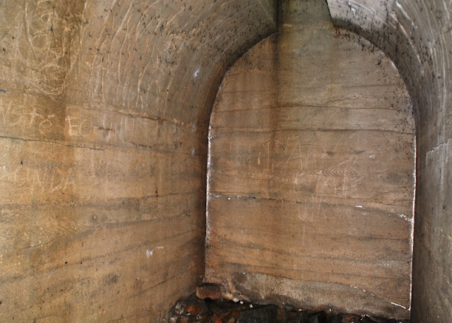
While the colors can be a bit boring in the winter, here's a good reason to explore when it's cold and there aren't any leaves on the trees. Unless you know it's there, the ruins of this home are pretty well shrouded by the leaves and would be easy to miss. I tried getting closer to the ruins but this time around, I was wearing my shorts so I didn't venture in too far.

This is a picture of the ruins from when I was hiking the Chapel Trail in April 2015

This is the one steep hill on the Chapel Trail although it's small. Watch your step if it's wet though, it's easy to slip and there was water still streaming down both sides of the hill into the small creek at the bottom.


Almost at Washington's Headquarters, this is a view of Mount Misery where I'd soon be hiking.

 |
| Valley Forge Train Station |

 |
| Washington's Headquarters |


Once past Washington's Headquarters, continue south and use the crosswalk to cross over PA State Route 23 (Valley Forge Park Road) and turn to the west. Note that this is a busy road and is also an intersection with PA State Route 252 (Valley Creek Road). Once you cross over, you'll see this plaque indicating the start of the Horse-Shoe Trail which is now 141 miles long.

View of Valley Creek from the bridge on PA State Route 23

Once you cross the bridge over Valley Creek, you'll see this white house and the signs for the Patriotic Order Sons of America and trail heads indicating the Valley Creek and Horse-Shoe Trails.


Follow the gravel driveway southwest past the Patriotic Order Sons of America building which will be on your left. You'll also be passing private property on your right.

 |
| Yellow marker for the Horse-Shoe Trail |
I probably should have backed up and only taken a single picture but this is an unnamed trail intersecting with the Horse-Shoe Trail. Last year, I stayed on the Horse-Shoe Trail so this time around, I decided to explore the trail to Colonial Springs.


One of a few spots on the trail where it was in the open. It was pretty humid on Saturday so I made sure to pick a place to hike that would be mostly in the shade.


After a short distance, the unnamed trail circles back to the Horse-Shoe Trail and over this small stream.


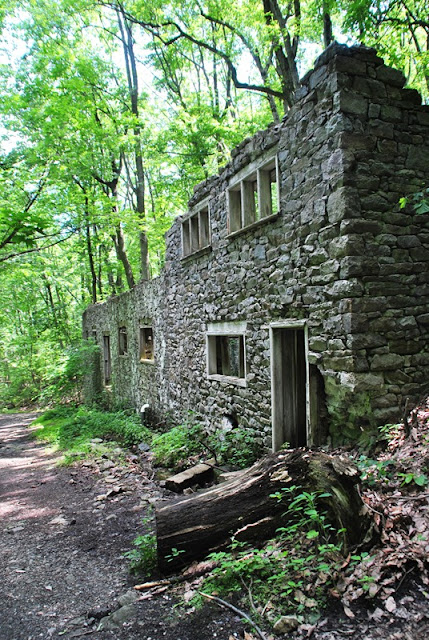
Continuing southwest and a little further up the trail is the Colonial Springs Bottling Plant. I can't seem to locate much information on when it was built but what I did find is that in 1908, General B. J. Fisher granted a lease to the Colonial Springs Company to use the water of Cold Springs for bottling. In 1900, Fisher has also sold 5000 gallons of the water to C.T. Chase.
As usual, I went a little crazy with taking pictures of the ruins, I can't help it! If you want to see what the building looked like while it was still in operation, click here.


Once you pass the ruins of the bottling plant, the trail takes a sharp turn to the northeast, the turns again to the southeast. Through most of the hike, the trails (that aren't gravel) were in good condition minus the few soggy spots from the rain earlier in the week.


The Horse-Shoe Trail branches off and continues to the southwest and from there, you will be on the Mount Misery Trail heading southeast (more south than east).

 |
| Horse-Shoe Trail heading towards the southwest. |


Close to the half-way point of the trail on Mount Misery, the Wolfinger Trail cuts to the east and down the mountain to the Valley Creek Trail.

Off the Wolfinger Trail is another side trail that will lead you to the edge of Mount Misery looking towards the bottom of the mountain and Mount Joy. Unfortunately, there isn't much of a view from the top but it's a steep drop. Years ago, friends of mine and I would hike up here to hang out along these rocks. Unfortunately, these pictures aren't the best since sun was so bright. It was a rough day for pictures altogether really....definitely not my best day for shooting.


Heading back out on the side trail on my way back to the Wolfinger and Mount Misery Trails.


A little further south from the Wolfinger Trail is another side trail, this time heading west, that's not listed on any of the maps of Valley Forge although it looks to be well maintained. I decided to follow it until I reached the NPS (National Park Service) boundary marker. After looking at it in Google Maps, it looks to lead to private property so I turned back once I reached this marker. Perhaps someday I'll return to see where this trail leads.


I returned back to the Mount Misery Trail and continued my trek to the south.


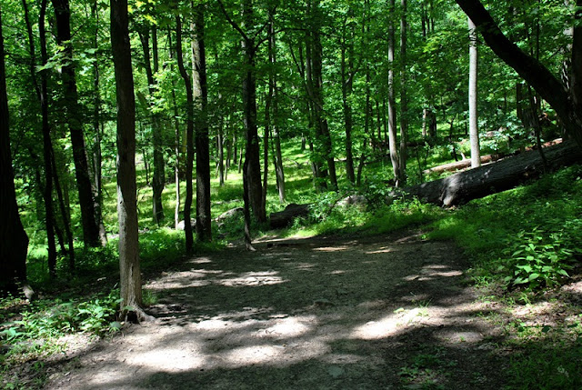
This area was probably the best section of the trail. On both sides and unlike most of the hike on the Mount Misery Trail, the plants in this area are plentiful and a lush green color. When I was there last year, I was going to take pictures but there were too many people on the trail that day. This time, I was a bit more patient and waited for people to pass so I could get my pictures. Again, they're not the best shots due to the sun but it was still worth it to me. At this point, I was heading back down the opposite side of the mountain.


 |
| Trail head on the southern end of Mount Misery |
 |
| One last look back to the Mount Misery Trail |
This area has been changed since the last time I was there. Last year, this trail head used to be a small parking lot which has now been closed off to vehicles and I also don't recall this crosswalk.

Last year, you also had to walk alongside Yellow Springs Road to get to the covered bridge. This makes it a little bit easier! The road is pretty narrow so you'd be close to traffic on the walk to the Valley Creek Trail. I'm also curious to know what those panels are, I'm guessing they're solar panels but for what?


Bad habit here, I have to remember to keep my camera straight when shooting pictures!

Now heading north on the Valley Creek Trail and on my way to returning to the car. The Valley Creek Trail is gravel/crushed stone and is flat, relatively straight and can get boring after a while.


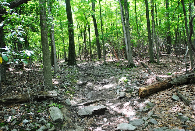
There are a few different hills similar to this one. Unfortunately, this doesn't look like much in pictures but it's a steep hill. The Wolfinger Trail and the area where I used to go with my friends back in the day is at the top of one of these. I don't remember if this is the one though.


 |
| Wolfinger Trail entrance from the Valley Creek Trail |
Built in the 1740's, the Upper Forge Site was a forge along Valley Creek that produced bar iron that was marketed in Philadelphia, as well as shoed horses, steeled plows, and provided for the needs of the local community. During its time in operation, trees from Mount Misery provided the wood for charcoal and a small stone dam was built to divert the water from the creek in order to power the bellows and hammer. The Upper Forge Site was one of two forges on Valley Creek that were in operation during the Revolution with the other being further downstream closer to Washington's Headquarters.


I finally managed to get a decent shot of a chipmunk. I usually scare them away as I get closer but this one was far enough away that it didn't take off.

I tried to find some information about this waterfall giving it's man made but was unable to. Perhaps this could have been the site of the other forge that was once in operation along Valley Creek.


By this time, I was back on the gravel section of the Horse-Shoe Trail nearing the bridge that crosses over Valley Creek on PA State Route 23.

 |
| Back on the Chapel Trail heading east |

 |
| Heading back up the hill to the chapel parking lot |
That was it for my adventure at Valley Forge. As always, it was a good hike but not the best day for shooting pictures. I have eventual plans to hike the Horse-Shoe Trail so I may be back in this area once again to see if I can start section hiking. In all, Valley Forge is an excellent place to go hiking and provides a good range of terrain from easy to difficult with most of the trails being in good condition. I'll likely return to explore a few trails I haven't been on yet but otherwise, I've covered most of the unpaved trails within the park.
Until next time, happy adventures and happy hiking!
Please give my Facebook page a like!
very nice! thanks for the info about the bottling plant! I was wondering what that was.
ReplyDeleteYou're welcome, thanks for stopping in!
Delete