Date of Hike: Sunday, June 22, 2014
Total Distance: 8.52 Miles*
Avg speed: 2.24MPH*
Avg moving speed: 2.37MPH*
Moving Time: 3:36:07
Total Time: 3:47:47
Conditions: Mostly Sunny, 80 degrees
Difficulty: Easy to Moderate
*I'm having some doubts about these statistics. I know I was moving at a decent pace for most of this hike and while I stopped a number of times to allow mountain bikers to pass and take pictures, I don't really think this would have had that much of an impact on my average and moving speeds. Another thing that makes me doubt these numbers is that there were quite a few tightly packed "S" turns or switchbacks on the trails, especially in the southern section. The switchbacks were not recorded properly by my GPS app and would have increased the distance I hiked as well as my moving speeds. By how much, I don't know but I don't think I was walking that slow. For perspective, I hiked Mount Misery in Valley Forge a few weeks ago which the terrain is far more difficult than these trails and my average moving speed was the same at 2.37MPH.
It was another beautiful day to go hiking as it has been for most of the spring/summer. My starting point was at the Tower Road parking lot in the northeastern section of the park. Approximate address is:
Ottsville, PA 18942

As of today, they're not yet named on the map from the DCNR's website so here are the trail names from north to south:
- Hammer Trail
- Cold Spot
- Haycock Run
- Eastern Woods
- Jay Walk
- South Park
For more information on the trails and the names, you can find a trail map on the Lake Nockamixon Bike Trails website (also called Ride Nox). If you scroll down to the bottom of the page, you can download a copy of the map in PDF format or you can get it by clicking here.
Once you arrive at the parking lot, the first thing you'll see at the trail head are wooden benches and chairs made from logs, pretty cool if you ask me.


 |
| Benches and chairs made from logs at the Tower Road trail head |
After last week's hike at the Church and Mink Trails and the poor condition they were in (for hiking), I didn't have much of an expectation for these trails and was anticipating another messy hike. Safe to say my expectations, or lack thereof, were laid to rest in a hurry. With the exception of a few places (very few at that), the trails in this part of the park are very well maintained and in excellent condition. I've been hiking just about every weekend since the snow melted earlier this year and these trails were by far the best I've been on condition-wise. Unlike the Church and Mink Trails, you can get away with wearing shorts in this section of the park without having to worry about walking through trails that are overgrown with weeds and thorn bushes. Make sure to bring your insect repellent, the black flies, gnats, whatever they're called, are a nuisance. It didn't help that my homemade bug repellent didn't work either.
A word of advice, keep in mind that these trails are designed for mountain bikers and from what I've read and experienced during my hike, this is a popular spot to go. There were quite a few mountain bikers on the trails and as they approached, I gave them right-of-way so they could keep moving. Most of them were friendly, said their hello's and thanked me as they passed.
Please also note that the trails in this area should not be used during wet weather or when they're soft and muddy. When you get to the trail head at Tower Road, you'll see a sign advising you that it's closed during wet weather. While there's no one there to stop you from going, in order to preserve the trails, prevent ruts and erosion, and keep them in the condition they're in, please abide by this and keep off the trails when they're wet. For information on trail conditions, please see the Ridenox Facebook page.
As far as the hike itself went, it was awesome. This part of the park is beautiful, the woods are pretty thick in this area and with the trails being as well kept as they are, it was a lot of fun to hike and enjoy. During my hike, I noted that I was no more than 40-50 feet away from the lake at certain places and while I could hear the waves, I could hardly see the water due to how thick the growth was.
The terrain throughout the hike is mostly level. It has a few hills but nothing real strenuous and there are a lot of small "mole hills" and lots of curves and swerves (keep in mind, these trails are designed for mountain bikers). The changes go from nice tightly packed ground to areas where you can tell it gets wet and has logs covering them and also some rocky stretches as well.
This is a good place to hike in the summer as you are mostly covered by shade (probably 90-95% of the time) so there will be some relief from the sun and heat throughout the hike.
 |
| Cold Spot trail close to the Tower Road trail head |
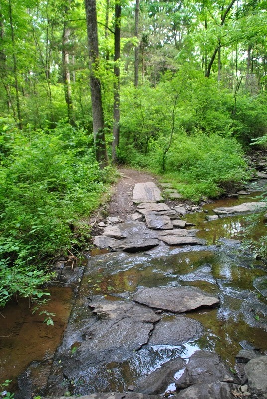 |
| First stream crossing on the Cold Spot Trail |

 |
| Stream just off the trail in the Cold Spot/Haycock Run area |
 |
| View of Lake Nockamixon from Haycock Run/Eastern Woods |
 |
| Section of Eastern Woods |
 |
| View of Lake Nockamixon from the Eastern Woods/Jay Walk sections |
 |
| Trail in Jay Walk section |
 |
| View of Lake Nockamixon from Jay Walk section |
As you get to the clearing in the Jay Walk section where the dam and fire road (Foellner Lane) are, look to your left towards the edge of the woods on the opposite side on the road and you'll see a small clearing with a Bicentennial Committee monument stone. The grass in the area is tall and overgrown but you can still walk up to it to shoot a picture.
 |
| Bicentennial Committee monument at the dam entrance in the Jay Walk section |
At this point, you're at the fence by the Tohickon Creek emergency spillway but there's no view of the overflow from here so there isn't much to see. As I was heading down the trail (Jay Walk leading into the South Park section), I was hoping to hike alongside the creek but the trail is about 100 feet above with a steep bank leading down to it. There are a few side trails leading down to the creek but I didn't take them. There is one spot with a rock ledge hanging over the bank where you can look over down to the creek. It's hard to tell but you can see the Tohickon in the background between the trees.
 |
| Rock ledge looking over the Tohickon (Jay Walk/South Park sections) |
 |
| Rocks protruding from the bank by overlook at the Tohickon (Jay Walk/South Park sections) |
As you get to the South Park section of the trail and approach South Park Road, the view of the Tohickon Creek from a clearing just under the bridge is very nice. You can get a good look at the creek from this spot. Be careful, the drop is a good 30 or more feet down. I didn't get close enough to the edge to see what was below and I didn't care to find out, I'm not fond of heights!


 |
| View of the Tohickon Creek and the South Park Road bridge |
As you approach South Park Road, there is a trail head here and plenty of parking alongside the road if you'd like to start your hike/mountain bike ride here instead of the Tower Road parking lot.
 |
| South Park Road trail head |
Here's a rocky section of the South Park trail leading up to...
 |
| Section of South Park trail |
The Gnome Home!! In the middle of seemingly nowhere, gnome statues are placed around a tree


 |
| I couldn't help it, I had to look behind the door...made me laugh out loud! |
 |
| Say hello to my little friend! |


After the Gnome Home, I didn't take many pictures for a distance.
 |
| Section of Eastern Woods |
 |
| 37 m To P...does this mean 37 miles to Philadelphia? Eastern Woods area |
 |
| Ride Nox, I believe this was on the Haycock Run section |
 |
| View of Lake Nockamixon from the Cold Spot/Hammer trail sections |
 |
| Stream bed between the Cold Spot and Hammer trails |
There are a few different trail heads on Mountain View Drive (Route 563) approximately in this area here


 |
| Trail head entrances on Mountain View Drive (Route 563) |

 |
| Sections of the Hammer Trail |
Along the Hammer Trail, there are a few wood carvings.

 |
| Wood carvings on Hammer Trail |
 |
| Fire road leading back to the Tower Road parking lot |
This may be one of my last trips out to Nockamixon State Park for a while since I've covered most of the trails although I'll definitely be returning to this area since it's so nice and well kept. As an added bonus, it's relatively close to home so it's well worth the drive to get to this set of trails. I was quite impressed!
Happy exploring and happy hiking!
No comments:
Post a Comment