Date of Hike: Saturday, June 20, 2015
Total Distance: 1.96 Miles
Avg speed: 2.36 MPH
Avg moving speed: 2.62 MPH
Moving Time: 44:51
Total Time: 49:39
Conditions: Partly Sunny, 80 Degrees
Difficulty: Easy*, Moderate, Difficult
This is part two of my adventures from this past Saturday the 20th. Like my hike at the Harmony Hill Nature Center, the "easy" rating was due to the East Branch Brandywine Trail with the rest of this short hike proving to be a pretty good workout. If you decide to explore the M. John Johnson Nature Center (also combined with the Sugar's Bridge Nature Area), you may want to bring a trail map with you. There's an information kiosk on the south end of the nature center but I didn't see it so I'm not sure if maps are provided. For some additional information about the nature center, head to the recreation section of East Bradford Township's website (scroll down towards the bottom of the page).
Parking for the M. John Johnson Nature Center can be found in two different locations with one of those parking lots being the same one you'd use if you were heading to the Harmony Hill Nature Center.
Approximate addresses are:
1195 Harmony Hill Road
Downingtown, PA 19335
GPS: 39.9762296,-75.6824926
810 Skelp Level Rd
West Chester, PA 19380
39.969613, -75.669972

Since I had just completed my hike at Harmony Hill Nature Area and parked in the parking lot on Harmony Hill Road, I didn't have to move the car. I took a quick break and headed into the nature center.

Alongside the storage garage, these concrete walls are the remnants of what used to be a trout hatchery at one time. When in use, water was diverted into the pond area by running pipes from a nearby stream channel. The pipes have since broken and the pond area is now only fed by storm water.


As usual, I didn't take many pictures of the paved trail. Once I reached this turn, I headed east up the hill under the power lines. This section of land is owned by PECO but is under conservation easement with the Brandywine Conservancy and under lease agreement with the West Chester Fish, Game and Wildlife Association.

From a distance, this hill looked smaller than it was. Once I started to climb it was when I realized I was about to get one heck of a workout! It's not as steep as some of the hills I've been on but it definitely got the blood pumping.

This is the view from relatively close to the top of this hill. The East Branch Brandywine Trail and Creek are somewhere at the bottom.

Once you get close to the top of the hill, it opens up into a field. The trail cuts south through a small wooded section close to the edge of the field, then back to the open field again.


Following the the edge of this field, it turns to the east and leads to two different trail heads that cut back to the south. I spotted the above wooden bench from a distance but didn't know what it was so I bypassed the first trail head to investigate.

Unlike the trails at the Harmony Hill Nature Area, the trails at M. John Johnson/Sugar's Bridge aren't nearly as well maintained. If you decide to hike here, it might be a good idea to wear long pants.


One I reached the bottom of the hill, the trail turned to the west, then back to the north. I was on the East Branch Brandywine Trail for a very short distance before finding this natural surfaced trail.


It turned out that heading north up this trail was also a good challenge. Like the hill under the power lines, it wasn't very steep but it was a long, gradual climb.


From this point on, I didn't take many more pictures since I was overlapping on trails I had already been on. Heading back down the hill under the power lines, I waited until I was about half way down before shooting this picture.


Last but not least and before leaving, I took a few shots of Gibson's Bridge, also known as Harmony Hill Bridge. Listed in the National Register of Historic Places in 1980, this covered bridge is 78 feet long, 14 feet wide and was built in 1872 at a cost of $2,666. Of 11 covered bridges that once crossed over the East Branch Brandywine Creek, this is the only one remaining. It acquired the name "Gibson's Bridge" from a local farmer by the name of James Gibson who owned land east of the bridge.
In 1959, the bridge was repaired and strengthened at a cost of $3,470. When Hurricane Floyd hit in 1999, the hurricane cracked the support to the bridge which took four years and $650,000 to repair.


Once I was done shooting pictures of Gibson's Bridge, it was back to the car and on my way home. In all, the M. John Johnson Nature Center/Sugar's Bridge Nature Area is a nice place but is small and with trails not being in the best of condition (besides the East Branch Brandywine Trail and the trail under the power lines), it may not be the best place to hike unless you don't mind the overgrown trails. If I return, it may be in the winter and combined with the Harmony Hill Nature Area just to add some distance to my hike.
Until next time, happy hiking and happy exploring!
Please give my Facebook page a like!
This is part two of my adventures from this past Saturday the 20th. Like my hike at the Harmony Hill Nature Center, the "easy" rating was due to the East Branch Brandywine Trail with the rest of this short hike proving to be a pretty good workout. If you decide to explore the M. John Johnson Nature Center (also combined with the Sugar's Bridge Nature Area), you may want to bring a trail map with you. There's an information kiosk on the south end of the nature center but I didn't see it so I'm not sure if maps are provided. For some additional information about the nature center, head to the recreation section of East Bradford Township's website (scroll down towards the bottom of the page).
Parking for the M. John Johnson Nature Center can be found in two different locations with one of those parking lots being the same one you'd use if you were heading to the Harmony Hill Nature Center.
Approximate addresses are:
1195 Harmony Hill Road
Downingtown, PA 19335
GPS: 39.9762296,-75.6824926
810 Skelp Level Rd
West Chester, PA 19380
39.969613, -75.669972

Since I had just completed my hike at Harmony Hill Nature Area and parked in the parking lot on Harmony Hill Road, I didn't have to move the car. I took a quick break and headed into the nature center.
 |
| East Branch Brandywine Trail heading southeast. |
 |
| Storage garage on the eastern side of the trail |

Alongside the storage garage, these concrete walls are the remnants of what used to be a trout hatchery at one time. When in use, water was diverted into the pond area by running pipes from a nearby stream channel. The pipes have since broken and the pond area is now only fed by storm water.


As usual, I didn't take many pictures of the paved trail. Once I reached this turn, I headed east up the hill under the power lines. This section of land is owned by PECO but is under conservation easement with the Brandywine Conservancy and under lease agreement with the West Chester Fish, Game and Wildlife Association.

From a distance, this hill looked smaller than it was. Once I started to climb it was when I realized I was about to get one heck of a workout! It's not as steep as some of the hills I've been on but it definitely got the blood pumping.

This is the view from relatively close to the top of this hill. The East Branch Brandywine Trail and Creek are somewhere at the bottom.

Once you get close to the top of the hill, it opens up into a field. The trail cuts south through a small wooded section close to the edge of the field, then back to the open field again.

 |
| Following the trail alongside the southern edge of the field |


Following the the edge of this field, it turns to the east and leads to two different trail heads that cut back to the south. I spotted the above wooden bench from a distance but didn't know what it was so I bypassed the first trail head to investigate.

Unlike the trails at the Harmony Hill Nature Area, the trails at M. John Johnson/Sugar's Bridge aren't nearly as well maintained. If you decide to hike here, it might be a good idea to wear long pants.

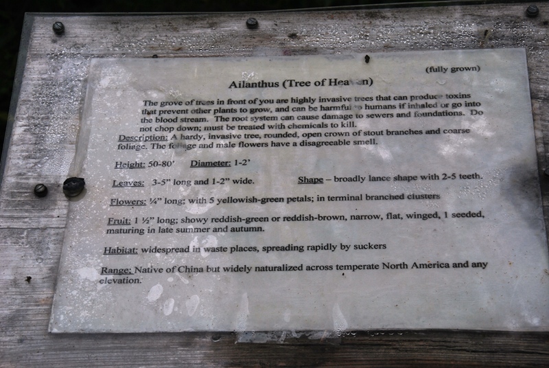 |
| Throughout the hike, there were a number of these signs identifying trees in the area. |


 |
| Gradually heading downhill towards the southern end of the nature center and the Brandywine Trail |


One I reached the bottom of the hill, the trail turned to the west, then back to the north. I was on the East Branch Brandywine Trail for a very short distance before finding this natural surfaced trail.


It turned out that heading north up this trail was also a good challenge. Like the hill under the power lines, it wasn't very steep but it was a long, gradual climb.


 |
| Back to the edge of the field |
From this point on, I didn't take many more pictures since I was overlapping on trails I had already been on. Heading back down the hill under the power lines, I waited until I was about half way down before shooting this picture.

 |
| Almost back to the East Branch Brandywine Trail |

Last but not least and before leaving, I took a few shots of Gibson's Bridge, also known as Harmony Hill Bridge. Listed in the National Register of Historic Places in 1980, this covered bridge is 78 feet long, 14 feet wide and was built in 1872 at a cost of $2,666. Of 11 covered bridges that once crossed over the East Branch Brandywine Creek, this is the only one remaining. It acquired the name "Gibson's Bridge" from a local farmer by the name of James Gibson who owned land east of the bridge.
In 1959, the bridge was repaired and strengthened at a cost of $3,470. When Hurricane Floyd hit in 1999, the hurricane cracked the support to the bridge which took four years and $650,000 to repair.


Until next time, happy hiking and happy exploring!
Please give my Facebook page a like!
No comments:
Post a Comment