Date of Hike: Wednesday, January 13, 2016
Total Distance: 13.17 Miles
Avg speed: 2.95 MPH
Total Time: 4:29:57
Conditions: Sunny, 25 Degrees
Difficulty: Easy
For my first adventure of the year after sustaining a pinched nerve in my neck, I decided to check out the Perkiomen Trail from Valley Forge to Collegeville. My previous hike on the Perkiomen Trail took me from Collegeville to Schwenkesville. Why it is I never start at one end or the other is beyond me but that's just how I do things. I just pick a spot and go. I did the same thing when hiking the Horse-Shoe Trail when I started in Great Valley instead of Valley Forge.
It was a pretty cold morning for a hike here in Southeast PA. When I first started, it was 20 degrees and only warmed up to 25 on the day. I was able to keep warm throughout the hike since I made sure to wear my insulated gear and kept moving at a decent pace, faster than I normally walk. The previous evening had brought us the first snow of the winter, less than an inch but since there was still some on the ground, I wanted to get out to enjoy it.
To start my adventure, I parked at the Pawlings Road parking lot in Valley Forge and went from there. The approximate address is:
1303 Pawlings Road
Phoenixville, PA 19460
GPS: 40.114081, -75.455594
According to Google Maps, this is still considered Phoenixville although it's closer to Audubon in my opinion. Regardless, the above address will get you to the parking lot which you won't be able to miss on your approach. You won't need it but if you'd like a copy of the trail map, click here. You can also grab the same map at kiosk stations scattered throughout the trail.

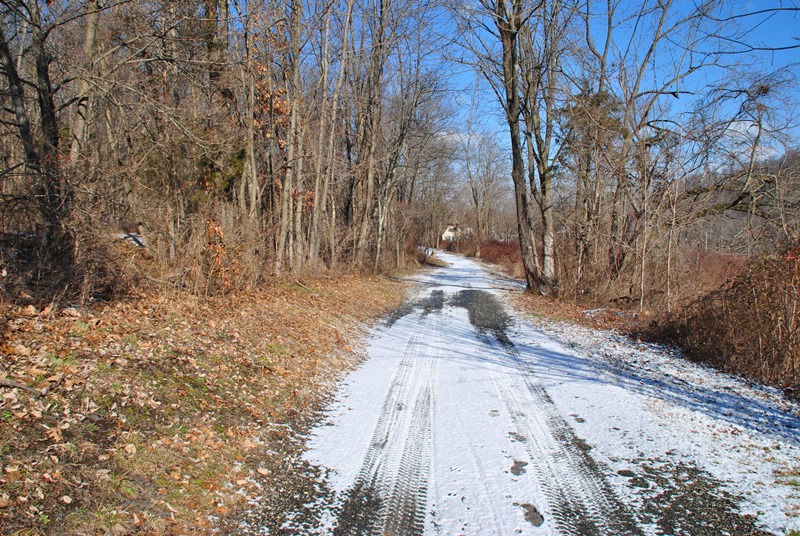
The Perkiomen Trail runs north to south so there wasn't a heck of a lot of changing directions during this adventure. When first starting your hike and if you start in the parking lot at Pawlings Road, you'll be on the Schuylkill River Trail for a short distance.

From the parking lot, you'll walk to the bottom of a small hill where you can head to Valley Forge or Oaks. To get to the Perkiomen Trail, you want to head towards Oaks.


Once you cross over the Perkiomen Creek, you'll reach an intersection where you can head west on the Schuylkill River Trail towards Phoenixville or east on the Perkiomen Trail towards Collegeville.


As stated, the Perkiomen Trail mostly runs in a north to south direction. After turning east onto the trail from the Station Avenue bridge, it turns to the north after a short distance. At this point, I was headed into the Lower Perkiomen Valley Park.


Across the Perkiomen Creek is the John James Audubon Center at Mill Grove which I hiked in March of 2015. Part of the Audubon Loop Trail includes the Perkiomen Trail through the Lower Perkiomen Valley Park.


This section was probably the coldest part of my hike. Since it was an open field, there was no cover from the wind.

Shortly after passing the entrance to Lower Perkiomen Valley Park, the Perkiomen Trail will take you under Egypt Road and alongside a small branch of the Perkiomen Creek.


The first road you'll get to and cross will be Upper Indian Head Road. Once you get there, the trail takes a turn to the west for a very short distance, then back to the north. You shouldn't have any problems finding the turns, they're well marked.


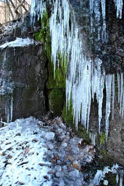
This was the beginning of the best part of the hike. Down this stretch of trail, very little sunlight beats on the cliffs that are on the southern side of the trail (in this area, the trail turns to the west for a short distance) and icicles were hanging from all of the cliffs and what an awesome sight it was! I went a little crazy with the pictures but it was worth it!


After getting past the above cliffs, I ran into this sign and thought I'd have to cut my hike short for the day. I'm not sure what trail might have been referenced with this sign but the Perkiomen Trail was still open.

Shortly after passing the above sign, I crossed over Cider Mill Road and spotted my possible answer as to why there might have been a trail closure. Since August 2013, the Arcola Road bridge (originally built in 1869, then rebuilt in 1931) had been deemed structurally deficient and was closed. Since then, construction has been ongoing with a projected completion date of July 2016.

After passing the bridge construction, I crossed over Arcola Road. Use caution here, it's on a somewhat blind turn and traffic can be moving at a decent clip. I also passed this old abandoned building and as much as my curiosity gets to me, I didn't check it out. I'd be curious to know what it was at one time though.


This small creek is known as Doe Run. It's hard to tell from the picture but where the water drops off the ledge (center of the picture), there were tire tracks leading into the creek on both sides. I'm not sure but I believe it's a driveway of sorts.

Throughout my hike, I spotted numerous side trails. Some of those trails were private property such as this one but there were others where there weren't any "no trespassing" or "private property" signs. Perhaps in time I'll return to check some of them out.


Along the trail was this memorial on a bench. Unfortunately, I couldn't find any information on who the woman was.


The next road crossing was at Yerkes Road and from there, it was another long, straight and flat hike.
Another abandoned building that was slowly falling apart. There were other structures nearby but none were close enough to get a decent shot. Like the others I saw on the trail, I'd be curious to know what they may have been at one time.


I didn't realize it at the time but I had entered into a section of the Central Perkiomen Park.


Another short distance further and I was crossing over State Route 29 (2nd Avenue) and by now, was almost to my destination.

I made it! It's not like there was any doubt about not making it but after not hiking for almost a month and walking faster than I normally do, I was ready for a rest! Unlike last time though, I didn't stop at the Appalachian Brewing Company and instead decided to have lunch at the Collegeville Diner which is right next door.

Once I was done with lunch, it was time to head back to Valley Forge.


Once I was back to the cliffs with all of the icicles hanging from them, I went picture crazy again. I couldn't help it, I've seen ice like this before but never had the opportunity to photograph it. Last winter, I was dealing with plantar fasciitis and didn't hike in the month of January at all.


Now back to Upper Indian Head Road, I spotted a trail that brought me to the side of Perkiomen Creek. While the Perkiomen Trail does take you in the direction of the creek, you're not always alongside it where you'd have an opportunity to get shots up close.


That was it for my adventure on the Perkiomen Trail for the day. Although I'm not too keen on hiking trails that are paved, flat, and straight (I'm the one who decided to go there though!), that doesn't mean it doesn't pose a challenge . I intentionally kept my pace faster than I normally do because of the cold which led to me getting tired a bit faster than I normally do. The Perkiomen Trail is also 19-20 miles long which I wouldn't be able to cover in a single day without a shuttle which I don't have. Even then, hiking 20 miles in a single day would be a new milestone for me.
In all, hiking a little over 13 miles at a fast pace after almost a month off isn't too bad. My legs are a bit fatigued a day later but thankfully not sore. I would have liked to have found some areas of historical significance but unfortunately, there wasn't a heck of a lot to be found and what I did find, I have no idea about the history. I do have plans on returning to this section of the trail to see if I can explore some of the side trails I spotted along the way.
Until next time, happy adventures and happy hiking!
For my first adventure of the year after sustaining a pinched nerve in my neck, I decided to check out the Perkiomen Trail from Valley Forge to Collegeville. My previous hike on the Perkiomen Trail took me from Collegeville to Schwenkesville. Why it is I never start at one end or the other is beyond me but that's just how I do things. I just pick a spot and go. I did the same thing when hiking the Horse-Shoe Trail when I started in Great Valley instead of Valley Forge.
It was a pretty cold morning for a hike here in Southeast PA. When I first started, it was 20 degrees and only warmed up to 25 on the day. I was able to keep warm throughout the hike since I made sure to wear my insulated gear and kept moving at a decent pace, faster than I normally walk. The previous evening had brought us the first snow of the winter, less than an inch but since there was still some on the ground, I wanted to get out to enjoy it.
To start my adventure, I parked at the Pawlings Road parking lot in Valley Forge and went from there. The approximate address is:
1303 Pawlings Road
Phoenixville, PA 19460
GPS: 40.114081, -75.455594
According to Google Maps, this is still considered Phoenixville although it's closer to Audubon in my opinion. Regardless, the above address will get you to the parking lot which you won't be able to miss on your approach. You won't need it but if you'd like a copy of the trail map, click here. You can also grab the same map at kiosk stations scattered throughout the trail.

The Perkiomen Trail runs north to south so there wasn't a heck of a lot of changing directions during this adventure. When first starting your hike and if you start in the parking lot at Pawlings Road, you'll be on the Schuylkill River Trail for a short distance.

 |
| Kiosk station at Pawlings Road parking lot, maps are available if you'd like to pick one up. |
From the parking lot, you'll walk to the bottom of a small hill where you can head to Valley Forge or Oaks. To get to the Perkiomen Trail, you want to head towards Oaks.


 |
| Station Avenue bridge over the Perkiomen Creek looking upstream towards Route 422 |
Once you cross over the Perkiomen Creek, you'll reach an intersection where you can head west on the Schuylkill River Trail towards Phoenixville or east on the Perkiomen Trail towards Collegeville.


As stated, the Perkiomen Trail mostly runs in a north to south direction. After turning east onto the trail from the Station Avenue bridge, it turns to the north after a short distance. At this point, I was headed into the Lower Perkiomen Valley Park.


Across the Perkiomen Creek is the John James Audubon Center at Mill Grove which I hiked in March of 2015. Part of the Audubon Loop Trail includes the Perkiomen Trail through the Lower Perkiomen Valley Park.


 |
| Small side trail off the Perkiomen Trail |

This section was probably the coldest part of my hike. Since it was an open field, there was no cover from the wind.

 |
| Kiosk station at the entrance to Lower Perkiomen Valley Park |
Shortly after passing the entrance to Lower Perkiomen Valley Park, the Perkiomen Trail will take you under Egypt Road and alongside a small branch of the Perkiomen Creek.


The first road you'll get to and cross will be Upper Indian Head Road. Once you get there, the trail takes a turn to the west for a very short distance, then back to the north. You shouldn't have any problems finding the turns, they're well marked.


This was the beginning of the best part of the hike. Down this stretch of trail, very little sunlight beats on the cliffs that are on the southern side of the trail (in this area, the trail turns to the west for a short distance) and icicles were hanging from all of the cliffs and what an awesome sight it was! I went a little crazy with the pictures but it was worth it!


 |
| Wall built into the cliff. I'm not sure why but I'd like to find out. |


After getting past the above cliffs, I ran into this sign and thought I'd have to cut my hike short for the day. I'm not sure what trail might have been referenced with this sign but the Perkiomen Trail was still open.

Shortly after passing the above sign, I crossed over Cider Mill Road and spotted my possible answer as to why there might have been a trail closure. Since August 2013, the Arcola Road bridge (originally built in 1869, then rebuilt in 1931) had been deemed structurally deficient and was closed. Since then, construction has been ongoing with a projected completion date of July 2016.

After passing the bridge construction, I crossed over Arcola Road. Use caution here, it's on a somewhat blind turn and traffic can be moving at a decent clip. I also passed this old abandoned building and as much as my curiosity gets to me, I didn't check it out. I'd be curious to know what it was at one time though.


This small creek is known as Doe Run. It's hard to tell from the picture but where the water drops off the ledge (center of the picture), there were tire tracks leading into the creek on both sides. I'm not sure but I believe it's a driveway of sorts.

Throughout my hike, I spotted numerous side trails. Some of those trails were private property such as this one but there were others where there weren't any "no trespassing" or "private property" signs. Perhaps in time I'll return to check some of them out.

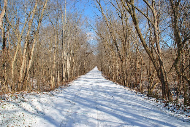
 |
| My favorite type of trail...long, straight, and flat... |

Along the trail was this memorial on a bench. Unfortunately, I couldn't find any information on who the woman was.


 |
| Next to the bench was this drop of about 30 feet down to the water |
 |
| Another side trail that I'd eventually like to investigate. |
 |
| Mile marker, getting somewhat close to Collegeville! |


The next road crossing was at Yerkes Road and from there, it was another long, straight and flat hike.

Another abandoned building that was slowly falling apart. There were other structures nearby but none were close enough to get a decent shot. Like the others I saw on the trail, I'd be curious to know what they may have been at one time.


I didn't realize it at the time but I had entered into a section of the Central Perkiomen Park.

After passing through Central Perkiomen Park (more accurately, a small section of it), I crossed over Perkiomen Boulevard

Another short distance further and I was crossing over State Route 29 (2nd Avenue) and by now, was almost to my destination.

I made it! It's not like there was any doubt about not making it but after not hiking for almost a month and walking faster than I normally do, I was ready for a rest! Unlike last time though, I didn't stop at the Appalachian Brewing Company and instead decided to have lunch at the Collegeville Diner which is right next door.

Once I was done with lunch, it was time to head back to Valley Forge.

 |
| I didn't spot this marker on the way to Collegeville |
 |
| I scared a deer off but it stood still long enough for me to get a few shots |

Once I was back to the cliffs with all of the icicles hanging from them, I went picture crazy again. I couldn't help it, I've seen ice like this before but never had the opportunity to photograph it. Last winter, I was dealing with plantar fasciitis and didn't hike in the month of January at all.


Now back to Upper Indian Head Road, I spotted a trail that brought me to the side of Perkiomen Creek. While the Perkiomen Trail does take you in the direction of the creek, you're not always alongside it where you'd have an opportunity to get shots up close.

 |
| View of Perkiomen Creek looking upstream |
 |
| A little further upstream was this dam. I believe I could have but I didn't walk up there for a closer look |
 |
| Looking downstream on Perkiomen Creek |

 |
| Approaching Lower Perkiomen Valley Park |

 |
| Dam at Lower Perkiomen Valley Park |
 |
| Passing under State Route 422 (Benjamin Franklin Parkway) |

 |
| Station Avenue bridge over the Perkiomen Creek, almost back to the parking lot! |
That was it for my adventure on the Perkiomen Trail for the day. Although I'm not too keen on hiking trails that are paved, flat, and straight (I'm the one who decided to go there though!), that doesn't mean it doesn't pose a challenge . I intentionally kept my pace faster than I normally do because of the cold which led to me getting tired a bit faster than I normally do. The Perkiomen Trail is also 19-20 miles long which I wouldn't be able to cover in a single day without a shuttle which I don't have. Even then, hiking 20 miles in a single day would be a new milestone for me.
In all, hiking a little over 13 miles at a fast pace after almost a month off isn't too bad. My legs are a bit fatigued a day later but thankfully not sore. I would have liked to have found some areas of historical significance but unfortunately, there wasn't a heck of a lot to be found and what I did find, I have no idea about the history. I do have plans on returning to this section of the trail to see if I can explore some of the side trails I spotted along the way.
Until next time, happy adventures and happy hiking!
No comments:
Post a Comment