Total Distance: 9.72 Miles
Avg Speed: 2.16 MPH
Avg Moving Speed: 2.34 MPH
Moving Time: 4:09:19
Total Time: 4:30:17
Conditions: Mostly Sunny, 80 Degrees
Difficulty: Moderate to Difficult
This past weekend, I went to French Creek State Park and rats! Once again, a little more than 1/4 mile short of my 10 mile objective! I thought I had it this time but obviously not. Perhaps next time. This was probably one of the most challenging hikes I've been on this season so far and the first in a while where I took my fully loaded backpack. The first leg of the adventure was relatively easy with some rolling hills and stops to check out a few historic places but once I started in a southeasterly direction just past Hopewell Furnace National Historic Site, that certainly changed. There are some steep hills to climb and some of the terrain was pretty rough. The DCNR's website says to "be sure to carry water and wear proper clothing and footwear" while on this section of trail. This is no joke, be sure to heed their advice.
While it's not even close, the best street address I could find to get to the parking lot was:
Douglassville, PA 19518
GPS: 40.2175062,-75.7752
The GPS coordinates are accurate though. If you come in from the north like I did, make sure you pass the street address and keep driving south until you find the parking lot on your right. If you come in from the south, it's not too far from when 345 branches off to the left and turns into Chestnut Road.

The first thing I noticed were the rocks in this area that looked like they were poured concrete. I'm going to have to do some research on this but I thought it was pretty interesting how all the rocks seemed crammed together to make a larger one.


This is the Mill Creek Trail as you first start your hike off Shed Road. As you can see, it's gravel but as you push further into the woods, it changes to a normal hiking trail. Be advised that most of the trails in this area are for hiking and mountain biking. I didn't see a single mountain biker during my hike but there were quite a few in the parking lot when I first arrived. My guess is they went a different direction.

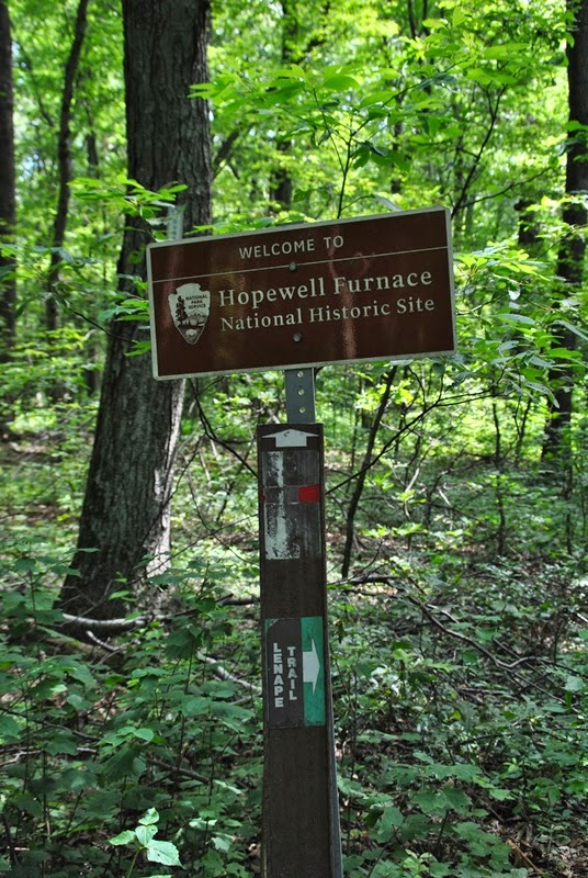
Walking up the Mill Creek Trail, it borders the Hopewell Furnace National Historic Site and as you cut to the southeast on the Lenape Trail, you are entering the site. As you can see, this part of the trail is in good condition and relatively easy to navigate.

 |
| Green blazes for the Lenape Trail |


 |
| More of these rocks that look like poured concrete |


 |
| Spring house on or close to the Lenape Trail |


Somewhere in this area was where things got a little bit confusing. As you can see from my tracks above, I ended up turning around a few times when I discovered I wasn't traveling in the direction I wanted to. While most of the trails inside Hopewell Furnace are in good condition, they're not well marked and also criss-cross with one another. Even with the map, I still ended up on the wrong trails a few times. I think it's safe to say my navigational skills need a little work!


I originally thought this building was a bird watch but spotted a sign as I was leaving that said at one time it used to be a concession stand. The door to the inner part of the building was open so I checked it out.


As I was walking in circles, I ran into some of the historical areas at Hopewell Furnace. Getting turned around isn't always a bad thing!


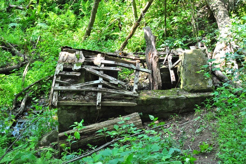
At this point, I had finally regained by bearings and ran into these ruins. There's no sign describing what it's about but the map of Hopewell Furnace labels it as the Site of Brison House.


 |
| Found the trail I was looking for!! |

As you get beyond Hopewell Furnace and re-enter into French Creek State Park, you start to see the trail markers again. When you push deeper into the park, the trails start to get a bit overgrown. This is also where the hike began to be a challenge. As you're heading southeast on the Buzzard's Trail, there's a nice sized hill that's relatively steep and was the first tough climb of the day.


As I reached the top of the hill on Buzzard's Trail, I decided to stop and take a rest to catch my breath. Just to my left, I found a charred tree. At first, I thought that perhaps it had been struck by lightning but as I continued my hike, I noticed more and more charred branches and trees scattered throughout the woods. When I got home, I decided to do some research and found that in April 2012, there had been a forest fire that started somewhere in Hopewell Furnace that was sparked by wind blowing trees down onto some power lines. It turns out that this was longest fire fight in Pennsylvania history and had burned a total of 741 acres. Since it started somewhere in Hopewell Furnace, it made me wonder how much I had walked past before noticing the charred trees.


As I reached the eastern-most part of Buzzard's trail, I once again took a wrong turn and ended up walking down to St. Peters Road and had to turn back again. The below picture is from the trail that lead to St. Peter's Road

 |
| I think this sign could use a little TLC |
 |
| More charred trees along the trail |

 |
| Some sort of fungus growing out of a dead tree |

 |
| Spring house on the Mill Creek Trail |


 |
| Stream bed alongside the Mill Creek Trail |


First crossing of Mill Creek. The rocks in this area remind me of St Peter's Village. If you've ever been there, there's a section of French Creek with huge boulders throughout the area. While the rocks here aren't as large as what's at St. Peter's, it's still a nice spot to snap a few pictures.


Raccoon Trail intersects the Mill Creek Trail in two different spots.


 |
| Second crossing of Mill Creek |

As you start getting close to the top of the hill, you get to what I believe is Miller's Point. I barely saw it since it was pretty well hidden by the leaves and trees but it's about 30-40 yards from Mill Creek Trail.


This was as close to the rocks as I could get, all those green leaves on the forefront were poison ivy.


As I made it to the top of Chestnut Hill a short distance from Miller's Point, I heard a few rumbles of thunder (or so I thought) so I stopped taking pictures and picked up the pace just in case there was a storm on the way. I never heard any more thunder and nothing ever materialized out of it but I'd rather be safe than sorry. On the way back to the car, I snapped off one more picture of the trail.
 |
| Mill Creek Trail on the way back to the parking lot |
In all, another good day hiking and another weekend of beautiful weather. This summer has been fantastic on weekends! I had heard in the news a few weeks ago that this area had 9 weekends in a row of sunny weather and after this past winter, there's no complaining about the heat, that's for sure! I'm looking forward to returning to French Creek State Park as there's a total of 35 miles of trails at this park and I covered just under 10. I've been here a number of times over the years but never in this part of the park. I'm glad to have explored it.
Happy adventures and happy hiking!
Please give my Facebook page a like!