Date of Hike: October 20, 2015
Total Distance: 7.5 Miles*
Avg speed: 1.3 MPH*
Total Time: 6:40:04*
Conditions: Mostly Sunny, 71 Degrees
Difficulty: Difficult
*These numbers are approximate due to the fact I had stopped and restarted my hiking app. I thought I was done with my hike when I returned to my car but decided to check out a few more spots that were further away than I had anticipated. Once I realized that, I started my hiking app again.
On Tuesday, October 20, I took a ride out to the Hawk Mountain Sanctuary to check out the fall colors and while it wasn't as colorful as I had hoped, it turned out to be one of the best hiking adventures I've been on since I started hiking two years ago. By far, it was also the most difficult hike I've been on as well which you'll see in a moment.
Be advised, if you're not an experienced hiker or in good physical condition, this hike will truly test your endurance. I don't mean to deter anyone from visiting Hawk Mountain because it's a beautiful place I think everyone should see but if you decide to visit, you should be prepared for some difficult hiking. To obtain a copy of the trail map, click here.
The address is:
1700 Hawk Mountain Road
Kempton, PA 19529
GPS: 40.635186, -75.987523
Enjoy the drive to Hawk Mountain as well, the roads leading up to it are beautiful! I wish I could have stopped to take pictures along the way.

Note that there is a $9 trail fee to explore Hawk Mountain and the proceeds from the membership and entrance fees go to support raptor conservation. A fee that's well worth paying!
Before starting my hike, I stopped into the visitor center to look around and pay my fee. In this area, the trail is made from stonework of sorts.

Close to the visitor center is this native plant garden which I had planned on visiting when I returned from hiking but forgot. Maybe next time!


Access to the trails on Hawk Mountain is across the street from the visitor center. As you enter into the sanctuary, you'll be walking through this kiosk area. Usually, there's someone sitting at the desk area to the right side but it was still early when I arrived. I noted the temperature was 71 degrees but in the morning hours when I arrived, it was still chilly (low 40's).

The Laurelwood Niche is a meeting place for many of Hawk Mountain's programs.


Hawk Mountain is a very popular place to visit if you like to see raptors of all sorts. During the fall especially, you'll see a number of migrating raptors heading south for the winter. To learn more about the raptors you'll see and their migration patterns (and a whole lot more), check out the RaptorPedia page on Hawk Mountain's website.

Hawk Mountain Sanctuary was the world's first refuge for birds of prey. In 1929, the Pennsylvania Game Commission placed a $5 bounty on the goshawk leading to thousands of them and other raptors being killed during their migration past the mountain. At the time, raptors were seen as nothing more than a nuisance and/or scavengers.
In 1931, an ornithologist by the name of Richard Pough took notice of the number of raptors being killed in the area and went to the mountain along with his brother and a friend, Henry Collins, to investigate. What they found were hundreds of dead and dying raptors which they lined up and took pictures of. Richard Pough spent the next few years trying with little success to raise attention to the killing and put an end to it.
In 1933 after speaking about the problem and showing pictures of the dead raptors at a meeting of the Hawk and Owl Society, the National Audubon Society sent a scout to investigate the killing but on the day they visited, there was no wind or raptors to be found and the matter was dropped.
In 1934, a woman by the name of Rosalie Edge reached out to Pough after hearing his plea in 1933 and leased approximately 1,400 acres at a cost of $500 with the option to buy. By 1938, Edge had raised enough funds to purchase the land at $2.50 an acre and the Hawk Mountain Sanctuary was born.

This was one of a number of trail signs you'll find posted in the section of the trails and is also where the fun begins!

The first opening you'll get to will be the South Lookout and it's quite a sight to behold.

When you look to the east from the South Lookout, you'll get your first view of the River of Rocks.

Once I was done at the South lookout (for now), I headed to the northwest. Known as the Lookout Trail, don't let it fool you, this is the easiest part of the hike!

The next overlook you'll get to is the Appalachian Overlook. The view from this overlook isn't as good but it's still beautiful!


The next overlook you arrive at will be the River of Rocks Overlook. As it's named, there's a good view of the River of Rocks from this overlook.


The next overlook is the Ridge Overlook. From there, you have a good view of the mountain on the opposite side of the below valley.


The next overlook you'll approach will be the Bald Overlook and is also where some of the fun really begins.

To get to this overlook, you'll have to climb these rocks, a taste of things to come!


This was the beginning of what was to be the most difficult hike I've been on since I started hiking again two years ago. Before getting to the Bald Lookout, the Lookout Trail is relatively easy and flat but it doesn't last very long. At this point, the Lookout Trail veers to the left still heading in a northwest direction and the trail I took, the Escarpment Trail, heads in the same direction parallel with the Lookout Trail, only a little further north.

All of the trails at Hawk Mountain were pretty well marked. Further along my hike, there were a few areas where it took me a moment to find the markers but they were there.
Here it is folks, this is the Escarpment Trail. If you look close to the center of the below picture, you'll see an orange trail marker on one of the rocks and another on a tree close to the top of this hill of rocks. This wasn't a trail, it was a pile of rocks with paint on it!
I don't wish to discourage anyone who decides to go hiking at Hawk Mountain but this is what you're going to run into when you go there. If you'd prefer to avoid the Escarpment Trail, you can continue on to the other overlooks using the Lookout Trail which is an easier hike. For me, the reason I went there was for the challenge. I surely wasn't disappointed and had a blast climbing over these rocks.


In the mid 1800's, a sandstone quarry was in operation on the top of Hawk Mountain. About 500 yards to the west of the North Lookout, the J.D. Stone & Co. Quarry operated at a place now known as the Hall of the Mountain King.
Initially, mules were used to haul wagon loads of sand from the quarry down the mountain to the Little Schuylkill Railroad. As time passed, rocks were loaded into large cars and eased down the mountain by a cable railroad (known as a slide) to the Little Schuylkill River. At the bottom of the slide, the rocks were crushed into sandstone and transported by rail to manufacturers south of the ridge. Quarrying sandstone on Hawk Mountain ended in the late 1800's when a fire destroyed the machinery.


In the early 1800's and like a number of places I had previously explored, the area around Hawk Mountain had a number of iron furnaces in operation nearby and the woodlands around the mountain were used to create charcoal. Although I didn't spot any, I'm sure if you look around, you may find the remnants of what used to be charcoal hearths.


Another easy section of the Escarpment Trail but it doesn't last long at all. After a short distance, you're back to climbing over rocks.


The next spot to get a view of the valley below and beyond is the 3/4 Lookout.


I finally made my way to the end of the Escarpment Trail.


Before heading to the North Lookout, I backtracked on a different trail (I believe this is a section of the Lookout Trail) towards the visitor center for a distance. I wouldn't find this out until later but what I was entering was the Hall of the Mountain King.


Once I reached the bottom of the stone staircase, I pushed a little further to right about where the railings in these pictures came to an end and turned around to head towards the North Lookout.


Once I reached the top of the stone stairs, I was on my way to the North Lookout.


The North lookout is the last of the bunch for the time being. This is the view looking to the southeast towards the River of Rocks.

While I was at the North Lookout, I ended up speaking with one of the Hawk Mountain volunteers. She told me that the owl perched on top of this log is used to attract hawks since they are natural enemies and a hawk will dive at the owl when they see it.


This is the view from the North Lookout looking to the north with what I believe to be the Little Schuylkill River and Railroad. The railroad is the line to the right and the line next to it (to the left) is the river.

I had hoped to get more pictures from the North Lookout but there were a number of people already sitting on the rocks looking to spot some raptors. Once I was done taking pictures, it was on to the next part of my adventure, the Skyline Trail which turns to the northeast. If you look at the below picture, you can see a light blue trail marker on one of the rocks.


The below sign states "rocky and rugged, need to climb up or down rocks, must have hands free" and rates it as most difficult. This my fellow readers is not a joke. The fun part of my hiking adventures is that I carry a digital SLR camera which can be a burden at times due to its size and weight.
Last year, I had purchased a camera that fits easily into one of the pockets of my cargo pants but unfortunately, the pictures it takes tend to be overexposed. It takes fantastic macro shots but for anything scenic, I resorted back to using the SLR which made this hike somewhat interesting in spots.


Like the Escarpment Trail, the Skyline Trail has a number of areas where you'll be climbing down or up rocks, only these are more steep and difficult. Holding on to a large camera while climbing up or down these rock faces is quite the task, but not impossible.


The less difficult sections of the Skyline Trail were few and far between to start and even these sections have their own share of difficulty. The rocks aren't as big but they're still there and you have to watch every step so you don't end up tripping and taking a spill.


The Golden Eagle Trail intersects with the Skyline Trail heading in a southward direction and will connect you to the River of Rocks Trail. I continued heading east on the Skyline Trail. Perhaps upon my return to Hawk Mountain, I'll explore the trails I missed.


Before the first Europeans from Holland and Sweden migrated to North America in the early 1600's, the Lenni Lenape or Delaware Indians lived on Hawk Mountain. Three main tribes made up the Lenape nation, the Unami (Turtle tribe), Wunalachtico (Turkey tribe), and the Minsi (Wolf tribe) and while they were all Lenape, each had different language dialects and likely different tribal customs. The Lenape who lived on Hawk Mountain were a part of the Unami tribe.


Once Europeans migrated to North America, first from Holland and Sweden, then England, Ireland, Scotland and Germany, they also brought with them new tools, guns, and farming practices that made life easier on the Lenape. However, what they also brought with them were diseases that wiped out the American Indians population. The settlers from the European nations also pushed the Lenape out of their own lands to the west either by seizing land or buying it at low prices. Due to these reasons, much of the Lenape history is unknown other than the accounts of them by the European settlers.

Another part of the challenge of Hawk Mountain is that while some of the rocks are large, some are also small enough to where they'll shift under your feet as you walk on them. Their looks can be deceiving since they seem large enough to where they won't move until you step on them and find out they do.


At about the half-way point of the Skyline Trail, there's an opening in the trees called the East Rocks where you can look across the valley to the South Lookout.


Eventually, the rocks on the Skyline Trail come to an end and the trail levels out. While it's still on the rocky side and other than the Lookout Trail, this is probably one of the easiest sections of the hike.


After a distance, you'll find another trail marker and the trail splits in two directions. If you keep heading to the east, you'll be on your way to the Appalachian Trail. If you turn to the south, you'll be on another section of the Golden Eagle Trail heading down the mountain to the River of Rocks. As much as I wanted to check out the Appalachian Trail, I turned to the south and headed down the mountain.

Connecting trail to the Appalachian Trail is to the left, the Golden Eagle Trail is to the right.


I stopped on these stone steps to take a short break and tighten the laces on my boots. I recently bought new ones (again!) and picked a good place to break them in!


Surprisingly, the hike down the Golden Eagle Trail into the valley wasn't as difficult as I thought it would be. It was a long hill but not nearly as steep as I had anticipated.


As I made my way into the valley, the fall colors on the trees became more vibrant.

When you get to the bottom of the hill, the River of Rocks Trail intersects with the Golden Eagle Trail and you have a choice to go in three different directions. You can continue heading south, or make turns to the east or west. At this point, I made a turn to the east.


Another section of the Hawk Mountain trails that weren't too difficult to hike although that wouldn't last very long.


As you're hiking along the River of Rocks Trail, you're also hiking parallel to the River of Rocks although you really can't see much of it on the northern side because of the trees. Once you get to the eastern edge of the River of Rocks, the trail becomes rocky again, only this time, the rocks were smaller which made for another type of difficult hiking.

As you get to the far edge of the River of Rocks, the trail loops to the south, then to the west. Once you start your turn to the west, you're also circling to the opposite side of the river of rocks.


This was by far the most beautiful part of the hike when it came to the fall colors. All around the River of Rocks (in total, there are three rocks "gardens"), the trees were beautiful.


At this spot, there's a trail marker signifying a turn to the north in the River of Rocks Trail which isn't mentioned on the trail map. Along with this turn is another trail heading to the south that's not on the trail map at all. I investigated it for a short distance but turned back. As much as I'd want to explore an unmarked trail, I was too far away from home to feel comfortable with continuing and turned back to the north.
Some of the trails in this area are wide enough for a single vehicle to travel which leads me to believe they might have been old roadways from when the sandstone quarry and iron furnaces were in operation. If that's the case, there's no telling how far that trail would have gone.

This view is from the western edge of the first of the rock gardens looking to the east where I had just been. Two of the three rock gardens are about the same size and the third is a smaller one.


Somewhere in this area, I took another short break to take in the scenery and grab a quick snack. I ventured out onto the rocks for a short distance on both the eastern and western sides of the first rock garden to get some pictures, but not too far. Like some of the rocks on the Skyline Trail, these rocks were large but also small enough to where some would move or shift when you stepped on them. By now, I was also feeling the fatigue from walking on rocks for a good part of the hike.

This is another intersection at the River of Rocks Trail where I had turned to the west to continue along the River of Rocks. Had I continued heading to the north, I would have ended up where I had turned to the east off the Golden Eagle Trail after getting to the bottom of the hill.


This is the second of the three rock gardens, again from the eastern edge looking to the west.


Another section of the second rock garden a little further to the west, looking northeast.


The second rock garden has a branch of rocks that head off in a southwest direction from the larger section.

This is the third of the three rock gardens and is much smaller than the other two.


One last look at the River of Rocks and I was on my way to returning to the South Lookout. By this time, I was close to finishing this part of my hike but the challenge wasn't over yet!


By now, I was making a gradual ascent back to the South Lookout where I had started my hike.

The River of Rocks Trail intersected with another unmarked trail that stated "No Entry" on its marker. Although curious, I didn't explore it but it looks like another of those trails that may have been used during the quarry and iron operations in the area.

The trail makes a turn to the northwest, then back to the southwest while climbing up the hill leading to the South Lookout.

As I looped to the southwest, I spotted a few buildings to the east and decided to investigate them. These look like the hostels you'd find on the Appalachian Trail. While Hawk Mountain is close, these are a bit of a distance away.

Just behind this second building was what looked like the trail that had the sign stating "No Entry" a short distance back.


Once I was done exploring the buildings, the River of Rocks Trail then loops back to the northwest. From here was the steepest and longest climb of the day. By now, it's safe to say that I was pretty tired from the adventure. Having to haul up a steep hill after walking on rocks for several hours took quite a bit of effort.


Sign for the River of rocks Trail that states:
1.2 miles to boulder field
4 miles to complete entire loop
Rocky throughout. Allow at least 3-4 hours of daylight to complete
With this being said, I'm inclined to agree that it would take this long to complete the hike. Usually, a four mile hike would take less than two hours to complete but that's giving the terrain is easier to traverse and conditions are good.
My hike around Hawk Mountain was about 5.6 miles and took just under 5.5 hours putting me at an average of approximately 1 MPH. Normally on other trails I've been on, I usually average from 2 to around 2.4 MPH including stops to take pictures. I probably could have completed this hike sooner but I took a lot of pictures and for good reason, Hawk Mountain is AWESOME!

Once I was back at the South Lookout, I took another picture of the River of Rocks. By now, it was much warmer outside than it had been when I started my hike and the mist had lifted making this picture more clear.

One last shot from the South Lookout looking to the east and the River of Rocks and from there, I headed back to the car for the time being.

My intention was to check out the other lookouts that I didn't visit earlier in the day. For some silly reason, I underestimated the distance I would have to hike to get to them and when I returned to the car, switched to a different pair of shoes thinking I wouldn't be hiking too far. Lesson learned, this added at least another two miles to my hike in shoes that were less than comfortable for anything more than a night out on the town.
I returned to the South Lookout, then took the Lookout Trail back to the northwest. Instead of hitting the Escarpment Trail like I had done earlier in the day, I continued following the Lookout Trail. Once I made the turn was when I started to shoot pictures again. Like most of the others on Hawk Mountain, this trail has a lot of rocks.


A little more information on the Hall of the Mountain King including some of what the sandstone was used for (building material and glassware).

The two overlooks that I hadn't visited were the Sunset Overlook and The Slide.


Getting to the Sunset Overlook took some climbing but it wasn't too bad.


Unfortunately, the view at the Sunset Overlook is shrouded by trees.


This sign contains information about the killing of raptors in the late 1920's and how Richard Pough and Rosalie Edge put an end to the killing.

This area is known as The Slide. I didn't spot it while I was looking around but there are supposed to be remnants of the cable system that brought cars of rocks down the side of the mountain to the Little Schuylkill River and Railroad.

Next to the trail leading to The Slide were the remnants of this stone structure. What it was at one time, that part I don't know.


After exploring the other lookouts, I walked around for a while longer and returned to a few of the ones I had been to earlier in the day. As tired as I was, I didn't want to leave for home yet.

I'm not sure if this is what I think it might be but on the Lookout Trail alongside the stone steps leading towards the North Lookout was this hole in the rock. What caught my attention was that it's nearly perfectly round. Perhaps at one time, this section of stone was being drilled?


I'm not really sure which lookout this is but it had a nice view.

Once I was done exploring, I returned to the South Lookout to take in the sights one more time before hitting the road back to the home front. Without any doubts, I would and will return to the Hawk Mountain Sanctuary to hike again. By far, this was the most challenging hike I've been on in the last two years of hiking (I think I already said this but I'm saying it again). There are rocks everywhere and keeping your balance throughout along with climbing up and down piles of rocks requires constant use of your leg muscles, especially the thighs.
Normally, it would take a day or so for the fatigue to set in and the legs to start feeling sore from the abuse of hiking but this time around, I was feeling it before I even got home. Over the next few days, my legs were pretty tired but I wouldn't hesitate to do it again. It was an excellent adventure!
Until next time, happy adventures and happy hiking!
Please give my Facebook page a like!
*These numbers are approximate due to the fact I had stopped and restarted my hiking app. I thought I was done with my hike when I returned to my car but decided to check out a few more spots that were further away than I had anticipated. Once I realized that, I started my hiking app again.
On Tuesday, October 20, I took a ride out to the Hawk Mountain Sanctuary to check out the fall colors and while it wasn't as colorful as I had hoped, it turned out to be one of the best hiking adventures I've been on since I started hiking two years ago. By far, it was also the most difficult hike I've been on as well which you'll see in a moment.
Be advised, if you're not an experienced hiker or in good physical condition, this hike will truly test your endurance. I don't mean to deter anyone from visiting Hawk Mountain because it's a beautiful place I think everyone should see but if you decide to visit, you should be prepared for some difficult hiking. To obtain a copy of the trail map, click here.
The address is:
1700 Hawk Mountain Road
Kempton, PA 19529
GPS: 40.635186, -75.987523
Enjoy the drive to Hawk Mountain as well, the roads leading up to it are beautiful! I wish I could have stopped to take pictures along the way.

Note that there is a $9 trail fee to explore Hawk Mountain and the proceeds from the membership and entrance fees go to support raptor conservation. A fee that's well worth paying!
Before starting my hike, I stopped into the visitor center to look around and pay my fee. In this area, the trail is made from stonework of sorts.

Close to the visitor center is this native plant garden which I had planned on visiting when I returned from hiking but forgot. Maybe next time!


Access to the trails on Hawk Mountain is across the street from the visitor center. As you enter into the sanctuary, you'll be walking through this kiosk area. Usually, there's someone sitting at the desk area to the right side but it was still early when I arrived. I noted the temperature was 71 degrees but in the morning hours when I arrived, it was still chilly (low 40's).

The Laurelwood Niche is a meeting place for many of Hawk Mountain's programs.


Hawk Mountain is a very popular place to visit if you like to see raptors of all sorts. During the fall especially, you'll see a number of migrating raptors heading south for the winter. To learn more about the raptors you'll see and their migration patterns (and a whole lot more), check out the RaptorPedia page on Hawk Mountain's website.

Hawk Mountain Sanctuary was the world's first refuge for birds of prey. In 1929, the Pennsylvania Game Commission placed a $5 bounty on the goshawk leading to thousands of them and other raptors being killed during their migration past the mountain. At the time, raptors were seen as nothing more than a nuisance and/or scavengers.
In 1931, an ornithologist by the name of Richard Pough took notice of the number of raptors being killed in the area and went to the mountain along with his brother and a friend, Henry Collins, to investigate. What they found were hundreds of dead and dying raptors which they lined up and took pictures of. Richard Pough spent the next few years trying with little success to raise attention to the killing and put an end to it.
In 1933 after speaking about the problem and showing pictures of the dead raptors at a meeting of the Hawk and Owl Society, the National Audubon Society sent a scout to investigate the killing but on the day they visited, there was no wind or raptors to be found and the matter was dropped.
In 1934, a woman by the name of Rosalie Edge reached out to Pough after hearing his plea in 1933 and leased approximately 1,400 acres at a cost of $500 with the option to buy. By 1938, Edge had raised enough funds to purchase the land at $2.50 an acre and the Hawk Mountain Sanctuary was born.

This was one of a number of trail signs you'll find posted in the section of the trails and is also where the fun begins!

The first opening you'll get to will be the South Lookout and it's quite a sight to behold.

When you look to the east from the South Lookout, you'll get your first view of the River of Rocks.

 |
| View looking north from the South Lookout |
Once I was done at the South lookout (for now), I headed to the northwest. Known as the Lookout Trail, don't let it fool you, this is the easiest part of the hike!

The next overlook you'll get to is the Appalachian Overlook. The view from this overlook isn't as good but it's still beautiful!


 |
| On my way to the next overlook |
The next overlook you arrive at will be the River of Rocks Overlook. As it's named, there's a good view of the River of Rocks from this overlook.

 |
| I zoomed in as best as I could with my camera to get this shot |


The next overlook is the Ridge Overlook. From there, you have a good view of the mountain on the opposite side of the below valley.


 |
| Bench alongside the Lookout Trail |
The next overlook you'll approach will be the Bald Overlook and is also where some of the fun really begins.

To get to this overlook, you'll have to climb these rocks, a taste of things to come!


 |
| Looking down to the Lookout Trail from the Bald Overlook |
This was the beginning of what was to be the most difficult hike I've been on since I started hiking again two years ago. Before getting to the Bald Lookout, the Lookout Trail is relatively easy and flat but it doesn't last very long. At this point, the Lookout Trail veers to the left still heading in a northwest direction and the trail I took, the Escarpment Trail, heads in the same direction parallel with the Lookout Trail, only a little further north.

All of the trails at Hawk Mountain were pretty well marked. Further along my hike, there were a few areas where it took me a moment to find the markers but they were there.
 |
| Beginning of the Escarpment Trail |
Here it is folks, this is the Escarpment Trail. If you look close to the center of the below picture, you'll see an orange trail marker on one of the rocks and another on a tree close to the top of this hill of rocks. This wasn't a trail, it was a pile of rocks with paint on it!
I don't wish to discourage anyone who decides to go hiking at Hawk Mountain but this is what you're going to run into when you go there. If you'd prefer to avoid the Escarpment Trail, you can continue on to the other overlooks using the Lookout Trail which is an easier hike. For me, the reason I went there was for the challenge. I surely wasn't disappointed and had a blast climbing over these rocks.


In the mid 1800's, a sandstone quarry was in operation on the top of Hawk Mountain. About 500 yards to the west of the North Lookout, the J.D. Stone & Co. Quarry operated at a place now known as the Hall of the Mountain King.
Initially, mules were used to haul wagon loads of sand from the quarry down the mountain to the Little Schuylkill Railroad. As time passed, rocks were loaded into large cars and eased down the mountain by a cable railroad (known as a slide) to the Little Schuylkill River. At the bottom of the slide, the rocks were crushed into sandstone and transported by rail to manufacturers south of the ridge. Quarrying sandstone on Hawk Mountain ended in the late 1800's when a fire destroyed the machinery.

 |
| Looking back down the pile of rocks I had just climbed |

In the early 1800's and like a number of places I had previously explored, the area around Hawk Mountain had a number of iron furnaces in operation nearby and the woodlands around the mountain were used to create charcoal. Although I didn't spot any, I'm sure if you look around, you may find the remnants of what used to be charcoal hearths.

 |
| One of the easier sections of the Escarpment Trail |


Another easy section of the Escarpment Trail but it doesn't last long at all. After a short distance, you're back to climbing over rocks.


The next spot to get a view of the valley below and beyond is the 3/4 Lookout.


I finally made my way to the end of the Escarpment Trail.


 |
| I believe this lookout is known as the Kettle View but I didn't see any signs labeling it |
Before heading to the North Lookout, I backtracked on a different trail (I believe this is a section of the Lookout Trail) towards the visitor center for a distance. I wouldn't find this out until later but what I was entering was the Hall of the Mountain King.


Once I reached the bottom of the stone staircase, I pushed a little further to right about where the railings in these pictures came to an end and turned around to head towards the North Lookout.


Once I reached the top of the stone stairs, I was on my way to the North Lookout.


 |
| Approach to the the North Lookout |
The North lookout is the last of the bunch for the time being. This is the view looking to the southeast towards the River of Rocks.

While I was at the North Lookout, I ended up speaking with one of the Hawk Mountain volunteers. She told me that the owl perched on top of this log is used to attract hawks since they are natural enemies and a hawk will dive at the owl when they see it.


 |
| View from the North Lookout looking to the northwest |
This is the view from the North Lookout looking to the north with what I believe to be the Little Schuylkill River and Railroad. The railroad is the line to the right and the line next to it (to the left) is the river.

I had hoped to get more pictures from the North Lookout but there were a number of people already sitting on the rocks looking to spot some raptors. Once I was done taking pictures, it was on to the next part of my adventure, the Skyline Trail which turns to the northeast. If you look at the below picture, you can see a light blue trail marker on one of the rocks.


The below sign states "rocky and rugged, need to climb up or down rocks, must have hands free" and rates it as most difficult. This my fellow readers is not a joke. The fun part of my hiking adventures is that I carry a digital SLR camera which can be a burden at times due to its size and weight.
Last year, I had purchased a camera that fits easily into one of the pockets of my cargo pants but unfortunately, the pictures it takes tend to be overexposed. It takes fantastic macro shots but for anything scenic, I resorted back to using the SLR which made this hike somewhat interesting in spots.


Like the Escarpment Trail, the Skyline Trail has a number of areas where you'll be climbing down or up rocks, only these are more steep and difficult. Holding on to a large camera while climbing up or down these rock faces is quite the task, but not impossible.

 |
| Looking back up the Skyline Trail after the downward climb |


 |
| One of the less difficult sections of the Skyline Trail |


The less difficult sections of the Skyline Trail were few and far between to start and even these sections have their own share of difficulty. The rocks aren't as big but they're still there and you have to watch every step so you don't end up tripping and taking a spill.

 |
| Fortunately, this pile of rocks was alongside the trail and not part of it! |


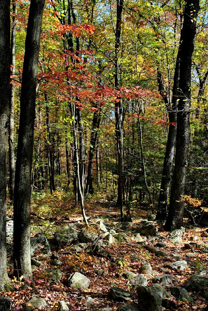
The Golden Eagle Trail intersects with the Skyline Trail heading in a southward direction and will connect you to the River of Rocks Trail. I continued heading east on the Skyline Trail. Perhaps upon my return to Hawk Mountain, I'll explore the trails I missed.


 |
| While the fall colors weren't the best, there were some areas that were pretty nice |


Before the first Europeans from Holland and Sweden migrated to North America in the early 1600's, the Lenni Lenape or Delaware Indians lived on Hawk Mountain. Three main tribes made up the Lenape nation, the Unami (Turtle tribe), Wunalachtico (Turkey tribe), and the Minsi (Wolf tribe) and while they were all Lenape, each had different language dialects and likely different tribal customs. The Lenape who lived on Hawk Mountain were a part of the Unami tribe.


Once Europeans migrated to North America, first from Holland and Sweden, then England, Ireland, Scotland and Germany, they also brought with them new tools, guns, and farming practices that made life easier on the Lenape. However, what they also brought with them were diseases that wiped out the American Indians population. The settlers from the European nations also pushed the Lenape out of their own lands to the west either by seizing land or buying it at low prices. Due to these reasons, much of the Lenape history is unknown other than the accounts of them by the European settlers.
 |
| View from the Skyline Trail looking northward |

Another part of the challenge of Hawk Mountain is that while some of the rocks are large, some are also small enough to where they'll shift under your feet as you walk on them. Their looks can be deceiving since they seem large enough to where they won't move until you step on them and find out they do.


At about the half-way point of the Skyline Trail, there's an opening in the trees called the East Rocks where you can look across the valley to the South Lookout.

 |
| Zoomed in shot of the South Lookout |


 |
| I believe this view is looking to the southeast in the direction of the River of Rocks |


Eventually, the rocks on the Skyline Trail come to an end and the trail levels out. While it's still on the rocky side and other than the Lookout Trail, this is probably one of the easiest sections of the hike.


After a distance, you'll find another trail marker and the trail splits in two directions. If you keep heading to the east, you'll be on your way to the Appalachian Trail. If you turn to the south, you'll be on another section of the Golden Eagle Trail heading down the mountain to the River of Rocks. As much as I wanted to check out the Appalachian Trail, I turned to the south and headed down the mountain.

Connecting trail to the Appalachian Trail is to the left, the Golden Eagle Trail is to the right.


 |
| One of a few garter snakes I spotted on the trails at Hawk Mountain |
I stopped on these stone steps to take a short break and tighten the laces on my boots. I recently bought new ones (again!) and picked a good place to break them in!


Surprisingly, the hike down the Golden Eagle Trail into the valley wasn't as difficult as I thought it would be. It was a long hill but not nearly as steep as I had anticipated.


As I made my way into the valley, the fall colors on the trees became more vibrant.

When you get to the bottom of the hill, the River of Rocks Trail intersects with the Golden Eagle Trail and you have a choice to go in three different directions. You can continue heading south, or make turns to the east or west. At this point, I made a turn to the east.


Another section of the Hawk Mountain trails that weren't too difficult to hike although that wouldn't last very long.


As you're hiking along the River of Rocks Trail, you're also hiking parallel to the River of Rocks although you really can't see much of it on the northern side because of the trees. Once you get to the eastern edge of the River of Rocks, the trail becomes rocky again, only this time, the rocks were smaller which made for another type of difficult hiking.


As you get to the far edge of the River of Rocks, the trail loops to the south, then to the west. Once you start your turn to the west, you're also circling to the opposite side of the river of rocks.


This was by far the most beautiful part of the hike when it came to the fall colors. All around the River of Rocks (in total, there are three rocks "gardens"), the trees were beautiful.


 |
| The rocks in the background on the hill are the South Lookout |


At this spot, there's a trail marker signifying a turn to the north in the River of Rocks Trail which isn't mentioned on the trail map. Along with this turn is another trail heading to the south that's not on the trail map at all. I investigated it for a short distance but turned back. As much as I'd want to explore an unmarked trail, I was too far away from home to feel comfortable with continuing and turned back to the north.
Some of the trails in this area are wide enough for a single vehicle to travel which leads me to believe they might have been old roadways from when the sandstone quarry and iron furnaces were in operation. If that's the case, there's no telling how far that trail would have gone.

This view is from the western edge of the first of the rock gardens looking to the east where I had just been. Two of the three rock gardens are about the same size and the third is a smaller one.


Somewhere in this area, I took another short break to take in the scenery and grab a quick snack. I ventured out onto the rocks for a short distance on both the eastern and western sides of the first rock garden to get some pictures, but not too far. Like some of the rocks on the Skyline Trail, these rocks were large but also small enough to where some would move or shift when you stepped on them. By now, I was also feeling the fatigue from walking on rocks for a good part of the hike.

This is another intersection at the River of Rocks Trail where I had turned to the west to continue along the River of Rocks. Had I continued heading to the north, I would have ended up where I had turned to the east off the Golden Eagle Trail after getting to the bottom of the hill.


This is the second of the three rock gardens, again from the eastern edge looking to the west.


Another section of the second rock garden a little further to the west, looking northeast.

 |
| View looking to the northwest |
 |
| View looking southward towards the trail |


The second rock garden has a branch of rocks that head off in a southwest direction from the larger section.

 |
| Back on the River of Rocks Trail |
This is the third of the three rock gardens and is much smaller than the other two.


 |
| Another garter snake alongside the trail |
One last look at the River of Rocks and I was on my way to returning to the South Lookout. By this time, I was close to finishing this part of my hike but the challenge wasn't over yet!


 |
| The third of three garter snakes I was able to get pictures of |

By now, I was making a gradual ascent back to the South Lookout where I had started my hike.

The River of Rocks Trail intersected with another unmarked trail that stated "No Entry" on its marker. Although curious, I didn't explore it but it looks like another of those trails that may have been used during the quarry and iron operations in the area.

The trail makes a turn to the northwest, then back to the southwest while climbing up the hill leading to the South Lookout.

As I looped to the southwest, I spotted a few buildings to the east and decided to investigate them. These look like the hostels you'd find on the Appalachian Trail. While Hawk Mountain is close, these are a bit of a distance away.

Just behind this second building was what looked like the trail that had the sign stating "No Entry" a short distance back.


Once I was done exploring the buildings, the River of Rocks Trail then loops back to the northwest. From here was the steepest and longest climb of the day. By now, it's safe to say that I was pretty tired from the adventure. Having to haul up a steep hill after walking on rocks for several hours took quite a bit of effort.


 |
| Getting close to the top of the hill and South Lookout |
Sign for the River of rocks Trail that states:
1.2 miles to boulder field
4 miles to complete entire loop
Rocky throughout. Allow at least 3-4 hours of daylight to complete
With this being said, I'm inclined to agree that it would take this long to complete the hike. Usually, a four mile hike would take less than two hours to complete but that's giving the terrain is easier to traverse and conditions are good.
My hike around Hawk Mountain was about 5.6 miles and took just under 5.5 hours putting me at an average of approximately 1 MPH. Normally on other trails I've been on, I usually average from 2 to around 2.4 MPH including stops to take pictures. I probably could have completed this hike sooner but I took a lot of pictures and for good reason, Hawk Mountain is AWESOME!

Once I was back at the South Lookout, I took another picture of the River of Rocks. By now, it was much warmer outside than it had been when I started my hike and the mist had lifted making this picture more clear.

 |
| Looking across the valley to the East Rocks on the Skyline Trail |

One last shot from the South Lookout looking to the east and the River of Rocks and from there, I headed back to the car for the time being.

My intention was to check out the other lookouts that I didn't visit earlier in the day. For some silly reason, I underestimated the distance I would have to hike to get to them and when I returned to the car, switched to a different pair of shoes thinking I wouldn't be hiking too far. Lesson learned, this added at least another two miles to my hike in shoes that were less than comfortable for anything more than a night out on the town.
I returned to the South Lookout, then took the Lookout Trail back to the northwest. Instead of hitting the Escarpment Trail like I had done earlier in the day, I continued following the Lookout Trail. Once I made the turn was when I started to shoot pictures again. Like most of the others on Hawk Mountain, this trail has a lot of rocks.


A little more information on the Hall of the Mountain King including some of what the sandstone was used for (building material and glassware).

The two overlooks that I hadn't visited were the Sunset Overlook and The Slide.


Getting to the Sunset Overlook took some climbing but it wasn't too bad.


Unfortunately, the view at the Sunset Overlook is shrouded by trees.


This sign contains information about the killing of raptors in the late 1920's and how Richard Pough and Rosalie Edge put an end to the killing.

This area is known as The Slide. I didn't spot it while I was looking around but there are supposed to be remnants of the cable system that brought cars of rocks down the side of the mountain to the Little Schuylkill River and Railroad.

Next to the trail leading to The Slide were the remnants of this stone structure. What it was at one time, that part I don't know.


After exploring the other lookouts, I walked around for a while longer and returned to a few of the ones I had been to earlier in the day. As tired as I was, I didn't want to leave for home yet.

I'm not sure if this is what I think it might be but on the Lookout Trail alongside the stone steps leading towards the North Lookout was this hole in the rock. What caught my attention was that it's nearly perfectly round. Perhaps at one time, this section of stone was being drilled?


I'm not really sure which lookout this is but it had a nice view.

Once I was done exploring, I returned to the South Lookout to take in the sights one more time before hitting the road back to the home front. Without any doubts, I would and will return to the Hawk Mountain Sanctuary to hike again. By far, this was the most challenging hike I've been on in the last two years of hiking (I think I already said this but I'm saying it again). There are rocks everywhere and keeping your balance throughout along with climbing up and down piles of rocks requires constant use of your leg muscles, especially the thighs.
Normally, it would take a day or so for the fatigue to set in and the legs to start feeling sore from the abuse of hiking but this time around, I was feeling it before I even got home. Over the next few days, my legs were pretty tired but I wouldn't hesitate to do it again. It was an excellent adventure!
Until next time, happy adventures and happy hiking!
Please give my Facebook page a like!