Date of Hike: Sunday, February 21, 2016
Total Distance: 11.54 Miles
Avg speed: 2.4 MPH
Total Time: 4:48:14
Conditions: Mostly Cloudy, 53 Degrees
Difficulty: Easy, Moderate, Difficult
This past Sunday, I took a ride out to Green Lane Park to explore some of the trails surrounding the reservoir. This place has been on my radar for a long time but I was torn between making an attempt at hiking around the entire reservoir in one day or hiking it a section at a time. That question was finally answered this past weekend and I decided I'd hike it in sections. With this being said, I'll be returning a few more times to explore the remaining trails which means there will be a few more blog posts about Green Lane Park by the time all is said and done.
It was a good day for a hike, not nearly as nice as it was for my adventure at Monocacy Hill Recreation Area the day before, but definitely nice enough for an adventure. Who am I kidding? Unless there's a blizzard or lightning, it's always a good day for an adventure! It was mild for February, let's put it that way.
There are numerous parking lots throughout Green lane Park so it's a matter of choosing where you'd like to start your adventure. For this hike, I parked in the parking lot on Green Lane Road:
Approximate address:
2153 Green Lane Road
Green Lane, PA 18054
GPS: 40.337022, -75.484109
For a copy of the trail map and to locate the other parking lots throughout the park, click here. Make sure to get an updated trail map for your adventure. The one I brought with me stated that the Blue Trail was 7.5 miles long but the updated map has it at 4 miles. Personally, I think it's somewhere in the middle. I strayed off the trail a few times but I don't believe it was enough to add 3.5 miles to my hike. If anything, I would put the Blue Trail at around 5 miles.


I started out my adventure heading to the south to check out the lakes. In total, there are three different bodies of water (excluding the Perkiomen Creek) at Green Lane Park; the Green Lane Reservoir, Knight Lake, and the one you see in the below picture Deep Creek Lake. Giving the warm weather and rain we've had, I was surprised to see there was still ice on the lake.
Interestingly enough, similar to Hopewell Lake at French Creek State Park, Deep Creek Lake was open to swimmers until 1994 when it was closed due to geese contaminating the water.


Following along the shoreline and looping to the northeast, there isn't much for a trail but it was easy to walk around the area. Like many places here in Pennsylvania, there are plenty of rocks.

This amphitheater was built between 2008-2009 (opened in 2009) and is now used for concert events throughout the summer.

I believe just before the bridge you see is another dam. Years ago, my family would meet at the park for picnics during the holidays. I recall fishing just downstream from that bridge. Never caught anything but it was still fun to get out and enjoy fishing.

Once I was done at the smaller lakes, it was time to find my way to the hiking trail. By now, I had circled along the driveway to the parking lot and turned west alongside Green Lane Road. This is a small section of the Perkiomen Trail.


The Perkiomen Trail veers away from Green Lane Road for a short distance, eventually turning back to the road again.


I finally made my way to the Blue Trail. From here, I crossed over Green Lane Road heading to the north.

Almost to the top of the hill, the Blue Trail had made a turn to the east.


The Blue Trail then makes a turn to the northeast. What you see below with the condition of the trail being relatively muddy was a taste of things to come. Giving the amount of rain we've had in recent weeks and the snow from Jonas melting, it was to be expected and is no fault of poor trail maintenance.
This area is also the location for one of two different campgrounds within Green Lane Park. The one you'll be cutting through if you hike the Blue Trail is designated for equestrian camping and contains only 10 sites. The other campground has 30 sites and is on the opposite side of Deep Creek Lake. For more information on the location(s), fees, and reservations, click here.

At first. the trail was in good condition and was mostly crushed stone/gravel.

Crossing over Hill Road and headed in the direction of Green Lane Reservoir. Once crossing over, the Blue Trail takes a turn to the west.

Throughout the hike on the Blue Trail, you'll see several of these signs posted warning you of difficult trail sections. Not all of them are difficult but if you hike this trail, be ready for a workout.

After seeing the warning sign, this was what I ran into and questioned if this was really what it was referring to. You can see the trail is relatively flat.


Shortly after thinking the warning sign was a waste, I found the hill(s) the sign was referring to and it's safe to say, they were on the difficult side.


I didn't take a lot of pictures on my return trip back to the car since it was a "there and back" hike and it had also started raining (I had also put my camera in a plastic bag and put it in my backpack). This hill doesn't look like much but when your legs are tired from hiking, it makes for one heck of a workout. The hill isn't steep by any means but it was a long and gradual climb on my return. My legs felt the burn for the next few days from this hike and Monocacy Hill the day before.
Somewhere in this area, the Blue Trail takes a turn to the north.


Eventually the hill brings you down to the level of the reservoir with some small openings where you can get a clear shot of the water and ice. The hill to the right side is where I had just been.


The Blue Trail takes a sharp turn to the southwest, then back to the northwest, and shortly after doing so, you'll cross over Hill Road. Take note that if you're looking at the Blue Trail on Google Maps, it looks like the trail has been redirected to a different area from what you'll see.


Once I had crossed over Hill Road, I noticed the Blue Trail wasn't going to bring me to the boat launch area which I had intended on exploring so I found a side trail and made my way over.

Directly across the reservoir from the boat launch is this bright orange arrow and the cliff to the left. I'm curious to know what the arrow is supposed to be used for.

After walking around the boat launch area for a little while, I was on my way again. Now heading to the west with an eventual turn to the northwest.


Another warning sign about difficult terrain being ahead. This time, although the trail was soggy and a bit slippery from being wet, these areas weren't nearly as difficult as the first hill I had climbed.


There are probably at least five or six stream crossings on the Blue Trail although none of them were difficult to cross. Had they been flooded, it may have ended my day early.


I don't often get shots of wildlife because I tend to walk with "heavy feet" and scare anything off before I can get close enough for a picture. This downy woodpecker gave me enough time to shoot a picture before taking off.

The Blue Trail walks you through a section of evergreen trees.


In this area and although I can't really tell where I was, the Blue Trail changes direction a few times, mostly headed in a northerly direction.


The Blue Trail takes a turn to the west with another trail leading to the water's edge. It's a bit hard to see but the white line at water level is a bridge crossing over the Green Lane Reservoir. Although I could see this bridge sooner, this was the first good shot of it I could get. The bridge was my objective.


I had finally reached my objective, the parking lot on the corner of Knight and Ward Roads. This is also where the Blue Trail turns into the Red Trail and crosses the reservoir. I'm not sure yet but this may be my starting point when I return to Green Lane Park. I hung out here for a little while to grab a snack and once I was done. it was time to head back to the car.
On the way back to the parking lot on Green Lane Road, I didn't snap off too many pictures. At about the half way point was when it started to rain. It didn't get heavy but being careless and not checking my gear before I left to go hiking, I didn't realize that I hadn't brought my rain gear along with me.


Once the rain started to fall more steadily, I made a quick stop and put my camera in my backpack to keep it protected from the elements. As I always do when I go hiking, I bring two cameras with me, the other I usually save for taking macro pictures since it does a fantastic job of getting the really close up shots. For the last few pictures, I had used the other less expensive camera. If that one gets wet and/or damaged, I wouldn't be as upset.


I pretty much packed everything in until getting back to the Perkiomen Trail alongside Deep Creek Lake and by then, the rain had stopped. Although it's not named. there are some trails leading into the meadows alongside the lake which I decided to explore on the way back to the parking lot.


That was it for my adventure at Green lane Park (for now). In all, it was a fantastic hike and one that I'd like to do again sometime. Although it was muddy, I'd have to say that for now, this is the best hike I've been on so far in 2016. Again, I'm not faulting anyone for the conditions of the trail. During this time of year, it's near impossible to keep the trails from getting muddy. The only gripe I had about Green Lane Park is that there's a shooting range just to the east (and slightly south) of the park which can be heard for a distance although I couldn't hear it the entire time.
There was an excellent mix of terrain, the trails were clean, and there was enough of a variety of scenery to keep me interested. Usually when you think of hiking around a lake (at least this is how I tend to think), you get the idea that the trails will be relatively flat and boring. It's safe to say that I was pleasantly surprised when hiking these trails, and tired!
Until next time, happy hiking and happy exploring!
This past Sunday, I took a ride out to Green Lane Park to explore some of the trails surrounding the reservoir. This place has been on my radar for a long time but I was torn between making an attempt at hiking around the entire reservoir in one day or hiking it a section at a time. That question was finally answered this past weekend and I decided I'd hike it in sections. With this being said, I'll be returning a few more times to explore the remaining trails which means there will be a few more blog posts about Green Lane Park by the time all is said and done.
It was a good day for a hike, not nearly as nice as it was for my adventure at Monocacy Hill Recreation Area the day before, but definitely nice enough for an adventure. Who am I kidding? Unless there's a blizzard or lightning, it's always a good day for an adventure! It was mild for February, let's put it that way.
There are numerous parking lots throughout Green lane Park so it's a matter of choosing where you'd like to start your adventure. For this hike, I parked in the parking lot on Green Lane Road:
Approximate address:
2153 Green Lane Road
Green Lane, PA 18054
GPS: 40.337022, -75.484109
For a copy of the trail map and to locate the other parking lots throughout the park, click here. Make sure to get an updated trail map for your adventure. The one I brought with me stated that the Blue Trail was 7.5 miles long but the updated map has it at 4 miles. Personally, I think it's somewhere in the middle. I strayed off the trail a few times but I don't believe it was enough to add 3.5 miles to my hike. If anything, I would put the Blue Trail at around 5 miles.

Green Lane Park is the largest county operated park within Montgomery County at a total of 3400 acres. The park, which was not named Green lane Park at the time, was opened to the public in 1959. I believe the land was owned at that time by the Philadelphia Suburban Water Company (now Aqua).
Green Lane Reservoir Park was established in 1983 when Montgomery County took over easement rights from the water company. Between 1983 and 1998, the area operated as two different parks (Green Lane Reservoir Park and Upper Perkiomen Valley Park) and in 1998, the two were merged to create Green Lane Park.

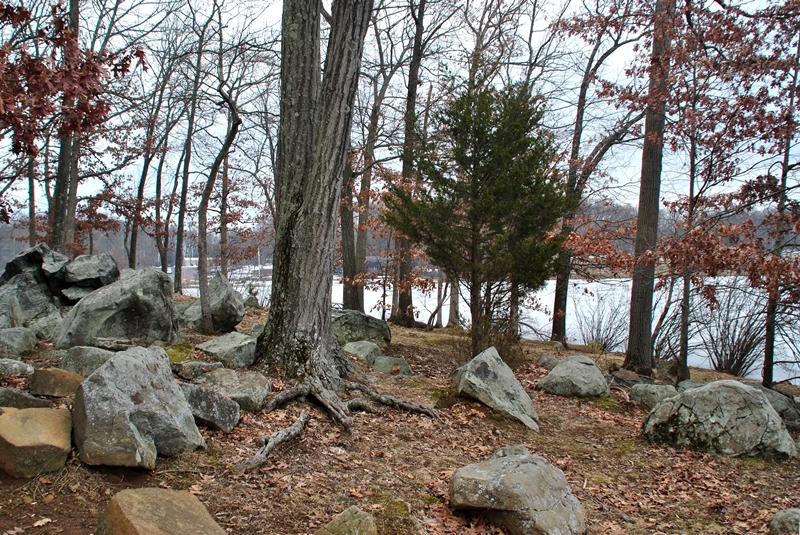
I started out my adventure heading to the south to check out the lakes. In total, there are three different bodies of water (excluding the Perkiomen Creek) at Green Lane Park; the Green Lane Reservoir, Knight Lake, and the one you see in the below picture Deep Creek Lake. Giving the warm weather and rain we've had, I was surprised to see there was still ice on the lake.
Interestingly enough, similar to Hopewell Lake at French Creek State Park, Deep Creek Lake was open to swimmers until 1994 when it was closed due to geese contaminating the water.


Following along the shoreline and looping to the northeast, there isn't much for a trail but it was easy to walk around the area. Like many places here in Pennsylvania, there are plenty of rocks.
 |
| The crack in the ice extended all the way across the lake |
 |
| First view of the dam and Knight Lake |
This amphitheater was built between 2008-2009 (opened in 2009) and is now used for concert events throughout the summer.

I believe just before the bridge you see is another dam. Years ago, my family would meet at the park for picnics during the holidays. I recall fishing just downstream from that bridge. Never caught anything but it was still fun to get out and enjoy fishing.

Once I was done at the smaller lakes, it was time to find my way to the hiking trail. By now, I had circled along the driveway to the parking lot and turned west alongside Green Lane Road. This is a small section of the Perkiomen Trail.


The Perkiomen Trail veers away from Green Lane Road for a short distance, eventually turning back to the road again.


I finally made my way to the Blue Trail. From here, I crossed over Green Lane Road heading to the north.

 |
| Looking back at Deep Creek Lake from the Perkiomen Trail |
 |
| Of course, immediately heading uphill on the Blue Trail! |
 |
| Another view looking back to Deep Creek Lake from the Blue Trail |
Almost to the top of the hill, the Blue Trail had made a turn to the east.


 |
| View looking down the hill towards the parking lot and Deep Creek Lake |
The Blue Trail then makes a turn to the northeast. What you see below with the condition of the trail being relatively muddy was a taste of things to come. Giving the amount of rain we've had in recent weeks and the snow from Jonas melting, it was to be expected and is no fault of poor trail maintenance.
This area is also the location for one of two different campgrounds within Green Lane Park. The one you'll be cutting through if you hike the Blue Trail is designated for equestrian camping and contains only 10 sites. The other campground has 30 sites and is on the opposite side of Deep Creek Lake. For more information on the location(s), fees, and reservations, click here.

At first. the trail was in good condition and was mostly crushed stone/gravel.

Crossing over Hill Road and headed in the direction of Green Lane Reservoir. Once crossing over, the Blue Trail takes a turn to the west.

Throughout the hike on the Blue Trail, you'll see several of these signs posted warning you of difficult trail sections. Not all of them are difficult but if you hike this trail, be ready for a workout.
 |
| Green Lane Reservoir in the background to the right side. |
After seeing the warning sign, this was what I ran into and questioned if this was really what it was referring to. You can see the trail is relatively flat.


Shortly after thinking the warning sign was a waste, I found the hill(s) the sign was referring to and it's safe to say, they were on the difficult side.


I didn't take a lot of pictures on my return trip back to the car since it was a "there and back" hike and it had also started raining (I had also put my camera in a plastic bag and put it in my backpack). This hill doesn't look like much but when your legs are tired from hiking, it makes for one heck of a workout. The hill isn't steep by any means but it was a long and gradual climb on my return. My legs felt the burn for the next few days from this hike and Monocacy Hill the day before.
Somewhere in this area, the Blue Trail takes a turn to the north.


Eventually the hill brings you down to the level of the reservoir with some small openings where you can get a clear shot of the water and ice. The hill to the right side is where I had just been.


 |
| Woodpeckers having their way with this tree stump! |

The Blue Trail takes a sharp turn to the southwest, then back to the northwest, and shortly after doing so, you'll cross over Hill Road. Take note that if you're looking at the Blue Trail on Google Maps, it looks like the trail has been redirected to a different area from what you'll see.


 |
| One of many soggy spots on the trail |
Once I had crossed over Hill Road, I noticed the Blue Trail wasn't going to bring me to the boat launch area which I had intended on exploring so I found a side trail and made my way over.

Directly across the reservoir from the boat launch is this bright orange arrow and the cliff to the left. I'm curious to know what the arrow is supposed to be used for.

After walking around the boat launch area for a little while, I was on my way again. Now heading to the west with an eventual turn to the northwest.


Another warning sign about difficult terrain being ahead. This time, although the trail was soggy and a bit slippery from being wet, these areas weren't nearly as difficult as the first hill I had climbed.


There are probably at least five or six stream crossings on the Blue Trail although none of them were difficult to cross. Had they been flooded, it may have ended my day early.

 |
| Slightly steep hill but not too difficult of a climb. |


 |
| Another stream crossing. |


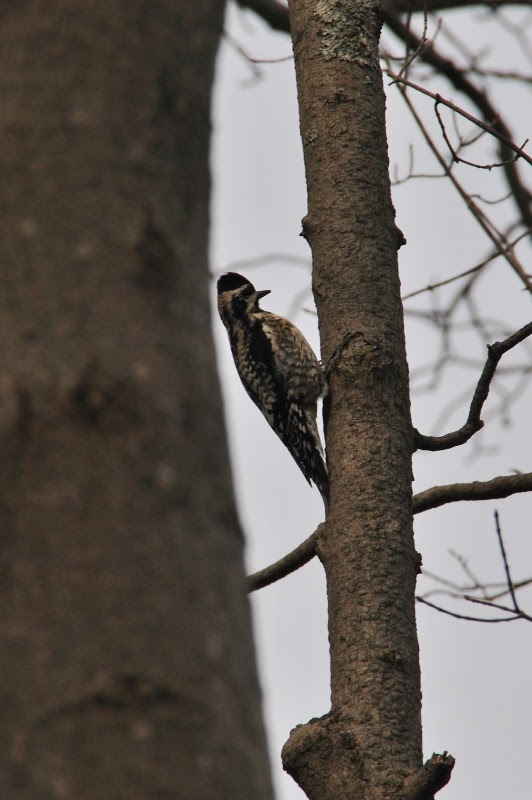
I don't often get shots of wildlife because I tend to walk with "heavy feet" and scare anything off before I can get close enough for a picture. This downy woodpecker gave me enough time to shoot a picture before taking off.
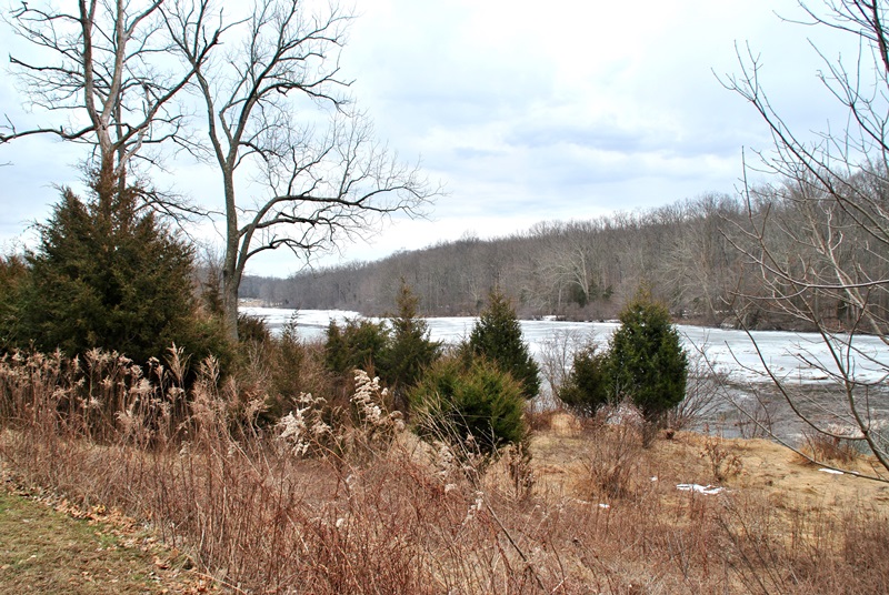
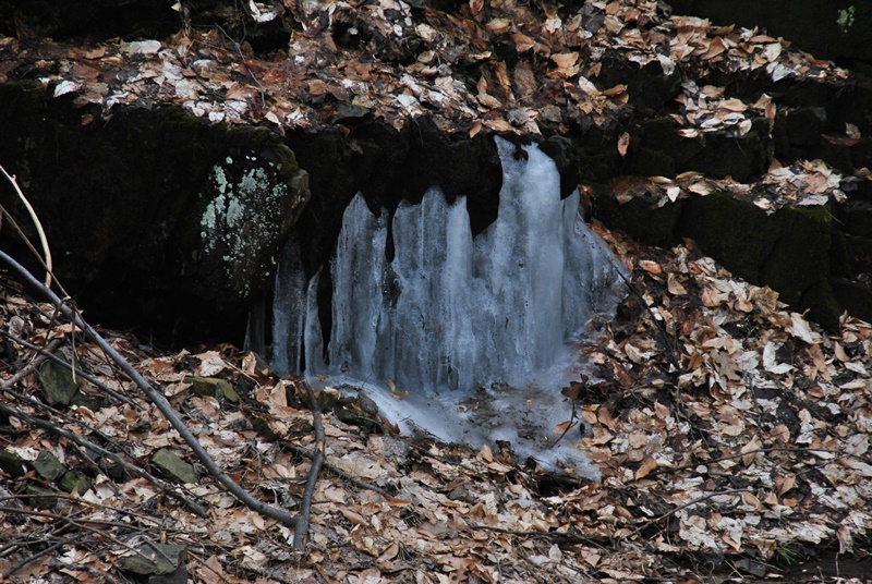
The Blue Trail walks you through a section of evergreen trees.


In this area and although I can't really tell where I was, the Blue Trail changes direction a few times, mostly headed in a northerly direction.


 |
| Small waterfall on the Blue Trail |


The Blue Trail takes a turn to the west with another trail leading to the water's edge. It's a bit hard to see but the white line at water level is a bridge crossing over the Green Lane Reservoir. Although I could see this bridge sooner, this was the first good shot of it I could get. The bridge was my objective.


 |
| The Blue Trail looping back to the north. |

 |
| Getting close to my objective |


I had finally reached my objective, the parking lot on the corner of Knight and Ward Roads. This is also where the Blue Trail turns into the Red Trail and crosses the reservoir. I'm not sure yet but this may be my starting point when I return to Green Lane Park. I hung out here for a little while to grab a snack and once I was done. it was time to head back to the car.
 |
| View of Green Lane Reservoir looking to the northeast |
On the way back to the parking lot on Green Lane Road, I didn't snap off too many pictures. At about the half way point was when it started to rain. It didn't get heavy but being careless and not checking my gear before I left to go hiking, I didn't realize that I hadn't brought my rain gear along with me.


Once the rain started to fall more steadily, I made a quick stop and put my camera in my backpack to keep it protected from the elements. As I always do when I go hiking, I bring two cameras with me, the other I usually save for taking macro pictures since it does a fantastic job of getting the really close up shots. For the last few pictures, I had used the other less expensive camera. If that one gets wet and/or damaged, I wouldn't be as upset.
 |
| Back to the boat launch area! |


I pretty much packed everything in until getting back to the Perkiomen Trail alongside Deep Creek Lake and by then, the rain had stopped. Although it's not named. there are some trails leading into the meadows alongside the lake which I decided to explore on the way back to the parking lot.


There was an excellent mix of terrain, the trails were clean, and there was enough of a variety of scenery to keep me interested. Usually when you think of hiking around a lake (at least this is how I tend to think), you get the idea that the trails will be relatively flat and boring. It's safe to say that I was pleasantly surprised when hiking these trails, and tired!
Until next time, happy hiking and happy exploring!