Date of Hike: Thursday, June 2, 2016
Total Distance: 3.53 Miles
Avg speed: 1.7 MPH
Total Time: 2:03:53
Conditions: Sunny, 86 Degrees
Difficulty: Easy
This post is going to be a little different than my previous ones but not by much. As I continue my explorations around Green Lane Park and with the discovery that there are a lot more trails than what you'll find on the trail map, I've returned two more times since my visit to the Red and Honeysuckle Trails to explore some of the unnamed trails in the east-central section of the park, north of Knight Road. With that being said, instead of creating two different posts, I combined both adventures into a single post since the areas I hiked are in close proximity to each other.
For both adventures, I changed direction numerous times and other than the first leg of each journey where I hiked the outskirts of each area first, I had no idea what direction I was going. My objective was to explore as many of the trails as I could which also led to some overlapping and criss-crossing of trails which you'll see in the tracks below. What this means is, I won't be able to try to guide you through the trails like I normally would. The best I can say would be to check out these trails for yourself.
A few items to note if you decide to explore these trails:
First, some of them are in very good condition where others are overgrown with tall grass. It's rare that I wear shorts when exploring but for those of you who do, I'd advise against it for both areas. Some of the grass was almost as tall as I was and much of it was at least waist high. In some areas, the trail disappeared altogether and I had to walk through the tall grass until I found the trail which you'll see in part two.
Second and more annoying, the deer/horse flies in this area were a complete nuisance! Unfortunately, you can douse yourself with bug spray and it won't stop these blood suckers since they hunt their prey by vision. At best, the most I could do to keep them from landing and taking a chunk out of me was to take my hat off and continually wave it around my head like a madman until they stopped pestering me. In case you may not know, they will follow you buzzing around your head for a good distance before giving up in search of an easier target.
For both adventures, I parked in the Knight Road Parking Area next to the paved section of the Red Trail.
Approximate address:
2226 Knight Road
Pennsburg, PA 18073
GPS: 40.361761, -75.505929


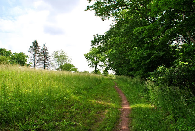
For the first leg of the journey, I was headed northwest. In this area, the trails are in excellent condition.

After short distance up the trail, it splits off in two directions. For the time being, I continued to the northwest staying close to the water. In this section, there's a gradual uphill climb.


As you hike a little further up the hill, you'll find a trail heading southwest back toward Knight Road and the reservoir. I took a small walk down this trail to get a look and once I discovered it would bring me back to the road, I turned back. I didn't get a close enough look but the trail was pretty steep. I took a few shots and kept moving.


Eventually, the trail will bring you somewhat close to the reservoir but the view is blocked by trees.


Bright sunlight and pictures don't always mix and maybe someday, I'll figure out how to adjust the aperture settings on my camera to allow less light in!

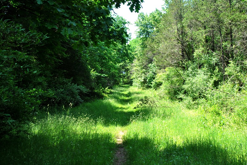
The further you go on these trails, the more overgrown they become.

Here's something I don't often see while hiking. The below insect is known as a hummingbird moth. The last time I saw one, I was in North Carolina several years ago!
Somewhere along this stretch of trail, it made a turn to the east, slowly turning to the southeast.


Back to the nicer looking trails, for now! Throughout both adventures, you'll find these wooden contraptions (I have no idea what they're really called) along the trails.

At this point, I spotted another trail heading back to the northwest and decided to check it out. Since I hadn't been following my GPS, I didn't realize that at this point, the trail was leading me around a small alcove.


Another opening alongside the trail with a view of the reservoir. In the center of this picture, you can see (barely) the Knight Road bridge crossing over.

I stopped to watch this for a little while. These two sunfish were courting and swimming around in circles. Any time another fish got too close, the larger of the two which I would assume is the male would chase them away.

At this point, I had reached the northernmost part of my hike and the trail seemed to come to an abrupt end close to this picnic table. Perhaps if I had looked around some more, I might have found additional trails but in this area, there's private property close by and I didn't want to be walking through someone's land to look for more trails. Looking at Google Maps and Google Earth, it looks like there might be but I'm not sure.


Once past the picnic table, I doubled back on another trail that was running parallel with the one I had just been on and was making my way back to the southeast.

A rare trail marker! I spotted a number of them during this hike, most of which were overgrown and almost hidden from view. I'm curious to know what the number on the bottom represents, perhaps a marker for maintenance crews.

The two trails that were running parallel with each other eventually merged back into one. After they merged, I made my way back to where I had originally turned to the northwest to explore the above area and made another turn to the southeast. After a distance, the trail took another turn to the southwest.

It seems not all of the trails in this section of the park are unnamed. Funny enough though, this was the only trail that was named or even had a sign. Since it was cutting through the woods, I decided to turn off the trail I was on and explore this one. For the time being, I was headed in a northwest direction.


Eventually, the trail (Dogwood?) made a turn to the northeast and right about in this area is where I really have no idea where I took pictures and where I didn't. The trail I was on changed direction a number of times before I made it back to some of the trail(s) I had already been on.


As I already mentioned, my objective was to explore as many trails as I could. Once I returned to the outskirts of the area and when I found a new trail, I would take a right turn, then left turns until I returned to the outskirts again. It wasn't completely fail proof but as far as I could tell, I covered most of the trails that were in this section of the park.


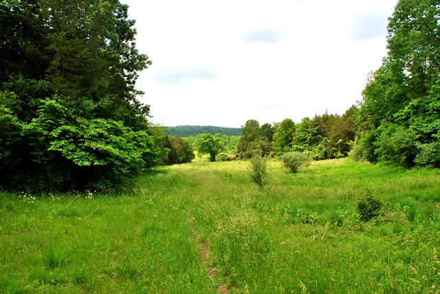
Many of the remaining trails throughout this area looked pretty much the same. They're wide enough for a vehicle (or tractor) to drive through and on some of the trails, not much cover from the sun.


Almost back to my starting point, there were a few short hikes through the woods again.


That was the end of my journey on June 2!
This post is going to be a little different than my previous ones but not by much. As I continue my explorations around Green Lane Park and with the discovery that there are a lot more trails than what you'll find on the trail map, I've returned two more times since my visit to the Red and Honeysuckle Trails to explore some of the unnamed trails in the east-central section of the park, north of Knight Road. With that being said, instead of creating two different posts, I combined both adventures into a single post since the areas I hiked are in close proximity to each other.
For both adventures, I changed direction numerous times and other than the first leg of each journey where I hiked the outskirts of each area first, I had no idea what direction I was going. My objective was to explore as many of the trails as I could which also led to some overlapping and criss-crossing of trails which you'll see in the tracks below. What this means is, I won't be able to try to guide you through the trails like I normally would. The best I can say would be to check out these trails for yourself.
A few items to note if you decide to explore these trails:
First, some of them are in very good condition where others are overgrown with tall grass. It's rare that I wear shorts when exploring but for those of you who do, I'd advise against it for both areas. Some of the grass was almost as tall as I was and much of it was at least waist high. In some areas, the trail disappeared altogether and I had to walk through the tall grass until I found the trail which you'll see in part two.
Second and more annoying, the deer/horse flies in this area were a complete nuisance! Unfortunately, you can douse yourself with bug spray and it won't stop these blood suckers since they hunt their prey by vision. At best, the most I could do to keep them from landing and taking a chunk out of me was to take my hat off and continually wave it around my head like a madman until they stopped pestering me. In case you may not know, they will follow you buzzing around your head for a good distance before giving up in search of an easier target.
For both adventures, I parked in the Knight Road Parking Area next to the paved section of the Red Trail.
Approximate address:
2226 Knight Road
Pennsburg, PA 18073
GPS: 40.361761, -75.505929
Part 1
For the first part of the adventure, the trail head is directly across the street from the parking lot, you won't be able to miss it.


 |
| Green Lane Reservoir from the back of the parking lot |
 |
| Crosswalk leading to the trail head across from the Knight Road Parking Area |
 |
| Japanese Wineberry starting to bloom |

For the first leg of the journey, I was headed northwest. In this area, the trails are in excellent condition.

After short distance up the trail, it splits off in two directions. For the time being, I continued to the northwest staying close to the water. In this section, there's a gradual uphill climb.


As you hike a little further up the hill, you'll find a trail heading southwest back toward Knight Road and the reservoir. I took a small walk down this trail to get a look and once I discovered it would bring me back to the road, I turned back. I didn't get a close enough look but the trail was pretty steep. I took a few shots and kept moving.


Eventually, the trail will bring you somewhat close to the reservoir but the view is blocked by trees.


Bright sunlight and pictures don't always mix and maybe someday, I'll figure out how to adjust the aperture settings on my camera to allow less light in!

The further you go on these trails, the more overgrown they become.

 |
| First view of the reservoir directly from the trail |
 |
| Small sunfish hanging out in the shallows close to where the trail was |
Here's something I don't often see while hiking. The below insect is known as a hummingbird moth. The last time I saw one, I was in North Carolina several years ago!
Somewhere along this stretch of trail, it made a turn to the east, slowly turning to the southeast.


Back to the nicer looking trails, for now! Throughout both adventures, you'll find these wooden contraptions (I have no idea what they're really called) along the trails.

At this point, I spotted another trail heading back to the northwest and decided to check it out. Since I hadn't been following my GPS, I didn't realize that at this point, the trail was leading me around a small alcove.


Another opening alongside the trail with a view of the reservoir. In the center of this picture, you can see (barely) the Knight Road bridge crossing over.

I stopped to watch this for a little while. These two sunfish were courting and swimming around in circles. Any time another fish got too close, the larger of the two which I would assume is the male would chase them away.

At this point, I had reached the northernmost part of my hike and the trail seemed to come to an abrupt end close to this picnic table. Perhaps if I had looked around some more, I might have found additional trails but in this area, there's private property close by and I didn't want to be walking through someone's land to look for more trails. Looking at Google Maps and Google Earth, it looks like there might be but I'm not sure.


Once past the picnic table, I doubled back on another trail that was running parallel with the one I had just been on and was making my way back to the southeast.

A rare trail marker! I spotted a number of them during this hike, most of which were overgrown and almost hidden from view. I'm curious to know what the number on the bottom represents, perhaps a marker for maintenance crews.

The two trails that were running parallel with each other eventually merged back into one. After they merged, I made my way back to where I had originally turned to the northwest to explore the above area and made another turn to the southeast. After a distance, the trail took another turn to the southwest.
It seems not all of the trails in this section of the park are unnamed. Funny enough though, this was the only trail that was named or even had a sign. Since it was cutting through the woods, I decided to turn off the trail I was on and explore this one. For the time being, I was headed in a northwest direction.


 |
| Some sort of funky moss along the trail |


Eventually, the trail (Dogwood?) made a turn to the northeast and right about in this area is where I really have no idea where I took pictures and where I didn't. The trail I was on changed direction a number of times before I made it back to some of the trail(s) I had already been on.


 |
| Overgrown trail marker |

As I already mentioned, my objective was to explore as many trails as I could. Once I returned to the outskirts of the area and when I found a new trail, I would take a right turn, then left turns until I returned to the outskirts again. It wasn't completely fail proof but as far as I could tell, I covered most of the trails that were in this section of the park.


Many of the remaining trails throughout this area looked pretty much the same. They're wide enough for a vehicle (or tractor) to drive through and on some of the trails, not much cover from the sun.


Almost back to my starting point, there were a few short hikes through the woods again.


That was the end of my journey on June 2!
Part 2
Date of Hike: Saturday, June 4, 2016
Total Distance: 6.47 Miles
Avg speed: 2.2 MPH
Total Time: 2:54:46
Conditions: Mostly Sunny, 82 Degrees
Difficulty: Easy, Moderate
Two days after exploring the unnamed trails across from the Knight Road Parking Area, I returned to the same parking lot to explore the unnamed trails just to the southeast. For this adventure, I had to jump on the Red Trail for a distance before crossing Knight Road to explore this section of the park.


As the Red Trail loops around and runs alongside Knight Road, you'll find a crosswalk, one of two that lead into this section of the park.

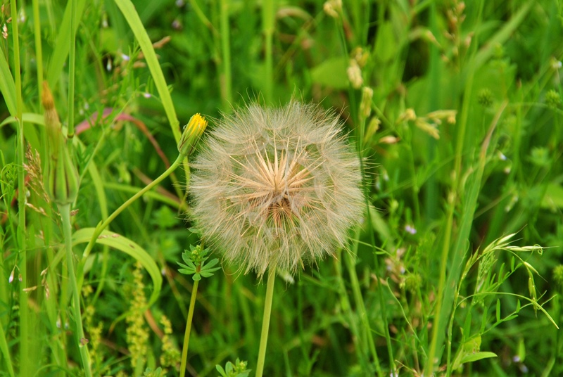
As I began my adventure on the unexplored and unnamed trails, I spotted this seed head. While this may look like a dandelion seed head, it's 3-4 times larger and is actually the seed head of a flower by the name of Tragopogon dubius or Yellow Salsify.

I didn't get a picture but as you reach the treeline, there are trails heading in opposite directions. Like my adventure from two days before this one, I took a left turn headed to the northwest to begin my explorations around the outskirts of the area.


As you reach the above fence, the trail turns to the north with a gradual turn to the northeast.

The trail continues its gradual turn, now heading to the east and this is where it opens up a little bit.

The common whitetail or long-tailed skimmer (male) is a dragonfly that can be found throughout North America. In this area, there was no shortage of them.

Known as the poanes hobomok, this butterfly is common throughout most of the central and eastern United States as well as Canada.

I can't count the number of times I've seen this but have never been able to catch it on camera. A pair of mating dragonflies, I believe they are common sanddragons.

Like my hike from June 2, there were a number of intersecting trails along the outskirts of this section of the park. By this point, the trail had turned to the southeast.


Now heading southwest alongside Red Hill Road.


After turning to the northwest, the trail disappeared and I ended up having to wade through the tall grass until I found the trail again.

Once I found the trail, I took another turn to the northeast and found this caterpillar hanging out on the trail. This looks to be a white ermine caterpillar but according to the research I've done, they're not native to north america at all. If anyone happens to have an idea as to what it is, please let me know.

Although there were trails, there was also a lot of tall grass which is why I recommend you wear long pants in this section of Green Lane Park if you decide to explore it.


After returning to the point where my tracks began overlapping, I used the same method as I had on June 2nd and at each trail I found heading toward the interior of this section, I took a right turn, then subsequent left turn(s) until I returned to the outer trail. Throughout the duration of my hike, this was the method I attempted to use. From about here on out, I changed directions way too many times to keep track so the best I can do is invite you to enjoy the next several pictures and explore this area yourself.


By the looks of it, I believe this is a Virginia Tiger Moth or Spilosoma virginica.


This picture was taken alongside the trail. I was impressed with how lush green it was in this area. By this point in my adventure, I was almost done with exploring these trails and was about to head back to the Red Trail.


On the way back to the parking lot (now on the Red Trail), I spotted this great blue heron. I'm not sure if it was the same one I had seen before and as I got closer, it took off.

Along the way back on the Red Trail, I took one of the side trails that run parallel with it to get a few minutes in the shade. Not to mention, the scenery on these side trails is better! At one point, the trail leads to the water's edge where I spotted these trees that look to have been taken down by a beaver.

Not far from the water's edge, the trail heads back up a hill and along with it, a somewhat decent view of Green Lane Reservoir


That was it for my adventure(s) exploring the unnamed trails in this section of Green Lane Park, at least for now. There are more unnamed trails to explore and I have yet to see if there are trails further north. I believe there may be since there are two more parking lots in the northeastern corner of the reservoir (Walt Road Day Use Area) and also the Church Road Bird Sanctuary on the northwestern side of the reservoir.
To give you a better idea of the sections of the park I explored, here's another shot with both combined hikes from a satellite view. The top left corner of this shot is where Knight Road crosses over the reservoir and the Red and Blue Trails meet.

In all, both days of exploring were good. I always enjoy exploring regardless of the conditions of the trails and with some of them being very nice and others not so much, I think they're worth checking out as long as you wear long pants and are ready to be pestered by deer/horse flies. Will I return to these trails? Maybe, but there are a lot of them at Green Lane Park that are in far better condition and well worth checking out. Even if you don't explore these sections of the park, there are enough trails to keep you busy for at least a few days.
If you'd like to combine hiking, fishing, boating, and camping, this place would be just about perfect. Horseback riding is also permitted at Green Lane but I'm not sure where or if you can rent horses in the local area. A quick internet search didn't return results worth posting. For campsite information, click here.
Until next time, happy adventures and happy hiking!
Two days after exploring the unnamed trails across from the Knight Road Parking Area, I returned to the same parking lot to explore the unnamed trails just to the southeast. For this adventure, I had to jump on the Red Trail for a distance before crossing Knight Road to explore this section of the park.


 |
| Green Lane Reservoir from the Red Trail, not far from the parking lot |


As the Red Trail loops around and runs alongside Knight Road, you'll find a crosswalk, one of two that lead into this section of the park.

As I began my adventure on the unexplored and unnamed trails, I spotted this seed head. While this may look like a dandelion seed head, it's 3-4 times larger and is actually the seed head of a flower by the name of Tragopogon dubius or Yellow Salsify.
I didn't get a picture but as you reach the treeline, there are trails heading in opposite directions. Like my adventure from two days before this one, I took a left turn headed to the northwest to begin my explorations around the outskirts of the area.


As you reach the above fence, the trail turns to the north with a gradual turn to the northeast.

The trail continues its gradual turn, now heading to the east and this is where it opens up a little bit.

The common whitetail or long-tailed skimmer (male) is a dragonfly that can be found throughout North America. In this area, there was no shortage of them.

Known as the poanes hobomok, this butterfly is common throughout most of the central and eastern United States as well as Canada.

I can't count the number of times I've seen this but have never been able to catch it on camera. A pair of mating dragonflies, I believe they are common sanddragons.

 |
| Female common whitetail skimmer |
Like my hike from June 2, there were a number of intersecting trails along the outskirts of this section of the park. By this point, the trail had turned to the southeast.


Now heading southwest alongside Red Hill Road.


After turning to the northwest, the trail disappeared and I ended up having to wade through the tall grass until I found the trail again.

Once I found the trail, I took another turn to the northeast and found this caterpillar hanging out on the trail. This looks to be a white ermine caterpillar but according to the research I've done, they're not native to north america at all. If anyone happens to have an idea as to what it is, please let me know.

Although there were trails, there was also a lot of tall grass which is why I recommend you wear long pants in this section of Green Lane Park if you decide to explore it.


After returning to the point where my tracks began overlapping, I used the same method as I had on June 2nd and at each trail I found heading toward the interior of this section, I took a right turn, then subsequent left turn(s) until I returned to the outer trail. Throughout the duration of my hike, this was the method I attempted to use. From about here on out, I changed directions way too many times to keep track so the best I can do is invite you to enjoy the next several pictures and explore this area yourself.


 |
| Another female common whitetail skimmer |

By the looks of it, I believe this is a Virginia Tiger Moth or Spilosoma virginica.


 |
| Not sure what this might have been, perhaps a fox den? |

This picture was taken alongside the trail. I was impressed with how lush green it was in this area. By this point in my adventure, I was almost done with exploring these trails and was about to head back to the Red Trail.


On the way back to the parking lot (now on the Red Trail), I spotted this great blue heron. I'm not sure if it was the same one I had seen before and as I got closer, it took off.

Along the way back on the Red Trail, I took one of the side trails that run parallel with it to get a few minutes in the shade. Not to mention, the scenery on these side trails is better! At one point, the trail leads to the water's edge where I spotted these trees that look to have been taken down by a beaver.

Not far from the water's edge, the trail heads back up a hill and along with it, a somewhat decent view of Green Lane Reservoir


 |
| Knight Road Bridge over the Green Lane Reservoir |
That was it for my adventure(s) exploring the unnamed trails in this section of Green Lane Park, at least for now. There are more unnamed trails to explore and I have yet to see if there are trails further north. I believe there may be since there are two more parking lots in the northeastern corner of the reservoir (Walt Road Day Use Area) and also the Church Road Bird Sanctuary on the northwestern side of the reservoir.
To give you a better idea of the sections of the park I explored, here's another shot with both combined hikes from a satellite view. The top left corner of this shot is where Knight Road crosses over the reservoir and the Red and Blue Trails meet.

In all, both days of exploring were good. I always enjoy exploring regardless of the conditions of the trails and with some of them being very nice and others not so much, I think they're worth checking out as long as you wear long pants and are ready to be pestered by deer/horse flies. Will I return to these trails? Maybe, but there are a lot of them at Green Lane Park that are in far better condition and well worth checking out. Even if you don't explore these sections of the park, there are enough trails to keep you busy for at least a few days.
If you'd like to combine hiking, fishing, boating, and camping, this place would be just about perfect. Horseback riding is also permitted at Green Lane but I'm not sure where or if you can rent horses in the local area. A quick internet search didn't return results worth posting. For campsite information, click here.
Until next time, happy adventures and happy hiking!