Date of Hike: Wednesday, September 9, 2015
Total Distance: *16.2 Miles
Avg speed: Unknown
Avg moving speed: Unknown
Moving Time: Unknown
Total Time: Approximately 6 hours
Conditions: Sunny, 91 Degrees
Difficulty: Easy, Moderate, some Difficult
*Once again, my GPS app lost its signal a few times during my hike which finally pushed me to make the decision to use a different app to track my progress. Since I started hiking, I've been using an app that works with Google by the name of My Tracks. Unfortunately, with the number of times I've lost my GPS signal in recent weeks, I've decided to make a switch to a new tracking app. Looking at the recent reviews, it turns out I'm not the only one who has been experiencing this problem. With this being said, it's going to change the format of my statistics a little bit and perhaps the screenshots of my hikes as well.
For the time being, I've made a switch over to US Topo Maps, both the free and pro versions...yes, I finally caved in and actually bought a GPS tracking app! With the switch to this new app, I also have some options that I didn't have before, namely a choice of numerous different map overlays. Here's a sample of one of the maps. I like that it shows the altitude rings better than what the terrain view of Google Maps has. The altitude rings look to be in 10 foot increments and they don't disappear when you zoom in.
Ok, time to get back on track. This past Wednesday, I returned to the Horse-Shoe Trail, this time between Valley Forge National Historical Park and the Great Valley Nature Center for what is now my longest hike of the season. It was a heck of a hike and to say I was tired by the end would be an understatement.
I started my hike from Varnum's Picnic Area which is about a mile east from the actual start of the Horse-Shoe Trail.

I've been down these trails a number of times so I didn't take too many pictures in the beginning. This is the trail leading down the hill from the parking lot that leads to the Chapel Trail. If you'd like to see the Chapel Trail, take a look at my post from what I hiked Mount Joy.


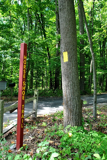
Here it is, the official beginning of the Horse-Shoe Trail. I took a picture of this when I hiked Mount Misery in June. From what I've recently read, the Horse-Shoe Trail is now 148 miles long.

These next few pictures are areas I've already been on as well.


There's a pretty long hill to climb before you get to where the Horse-Shoe Trail splits off to the west and the main reason I gave it a "some difficult" rating. The hill isn't too bad but what also makes this climb difficult are the rocks on the trail. You'll definitely need to watch where you're walking so you don't end up turning an ankle or tripping.
Once the Horse-Shoe Trail cuts to the west with the Mount Misery Trail continuing eastward, you'll find this trail register.

Like the rest of my recent hikes on the Horse-Shoe Trail, you'll be passing close to or through private property. Once you exit the boundary of Valley Forge, you'll see this fence alongside the trail.


Not too far from the above fence, you'll see this tin man and some other decorations alongside the trail.


The first road you'll cross over will be North Forge Mountain Drive.


I've seen this a number of times over the last few weeks and am curious to know what it might be. I believe this to be the work of mealybugs.

This section of the trail while short is very well taken care of. It looks like sandstone was laid down.


The next road you'll get to is Forge Mountain Drive and from there, a turn to the northwest for a very short distance. Once it intersects with High Point Lane, it turns back to the west again.


Heading west, you'll pass these few towers.


Once you pass the towers, you'll be following a dirt road for a short distance.

The dirt road will lead you to the Horseshoe Trail road and directly across the street is the Valley Forge Mountain Swim Club. This section of the Horseshoe Trail is paved for a distance.

You'll pass Horseshoe Pointe Drive along the way.

I'm not sure if this is what this sign is about but I found some information in the meeting minutes from the Schuylkill Township Board of Supervisors in regards to a request to build an amateur radio antennae on Valley Forge Mountain.


The paved Horseshoe Trail will then cross over Country Club and Clothier Springs Roads.


I ended up getting turned around in this area but it was by my own doing. I saw the below sign and walked past it, continuing on to the end of this section of the paved Horseshoe Trail. After turning around, I realized my mistake and kept moving. Once the Horseshoe Trail cuts to the south is where the unpaved Horse-Shoe Trail continues to the west.


The next roads you'll cross over are Chautauqua Trail and Wheelock Lane

I've had plans to explore the Diamond Rock Preserve but what I didn't know was that the Horse-Shoe Trail cuts right through the middle of it. Beginning in 1939, the Open Land Conservancy has protected approximately 482 acres of land from development in the Great Valley area.


Once you get to the western edge of the Diamond Rock Preserve, the Horse-Shoe Trail takes a turn to the northwest. Once you reach Howell Road, the trail then turns back to the west again.

The Horse-Shoe Trail then takes another turn off Howell Road to the northwest, then southwest, then northwest again alongside Rees Road.


The trail then crosses over Blackstone Road, still heading northwest.

A short distance after you cross over Blackstone Lane, you'll cross over Rees Road and into the woods across the street for a short distance.

The next road you'll get to is White Horse Road. Cross over the street and from there, the trail cuts through the woods alongside the road heading northeast.


Once you get to the corner of White Horse and Union Hill Roads, the trail turns again to the northwest.

Union Hill Road was probably one of the tougher challenges of the hike other than walking through Valley Forge. The hill there was a bit on the steep side and it was long.

Union Hill Road turns to the north, then makes another turn back to the northwest. Once it turns back to the northwest, the Horse-Shoe Trail then turns off the road heading to the west.

The Thompson Trail shoots off the Horse-Shoe Trail at Union Hill heading north and leads to Tinker Hill Road somewhere around the Graham Road area. With this one hike, I've now found two more places to check out on another day!

The Horse-Shoe Trail changes directions a few times after turning off Union Hill Road.


The trail will then lead you to Aldham Road and turns to the southwest.

Follow Aldham Road until you get to State Road (State Route 29). Directly across the street from there is Hollow Road and a very short distance from there is the Great Valley Nature Center.

At the Great Valley Nature Center, I stopped at a bench directly across the creek from the parking lot to take a break and get a bite to eat.


Intersection of State Road and Hollow Road. When I hiked the Horse-Shoe Trail from the Great Valley Nature Center to the Brightside Farm, I made note that I couldn't find the Horse-Shoe trail while exploring the nature center. The reason for this is that it doesn't cut through the nature center, it follows Hollow Road until it turns off right around here.
Note that if you'd like to check out the Thompson Trail, there's a small place to park on the eastern side of State Road. You could also park at the Great Valley Nature Center if you don't mind crossing over State Road which can be busy at times.

On my return to Valley Forge, I didn't take too many pictures. This is the view looking back towards the nature center on Aldham Road.

A few weeks ago, I mentioned that I have a bad habit of losing my towels while hiking. During my hike, my shoulder started to hurt a bit from my backpack so I made an adjustment to it. Apparently, when I made that adjustment, my towel also decided to jump off. Thankfully (sort of), it was hot outside so I noticed within a few minutes and was able to backtrack and pick it up.
While I'm mentioning it being hot outside, here's a small tidbit of information/word of caution. On my return hike back to Valley Forge and even though I was sweating from the heat, I started getting the chills which means my body was feeling the effects of heat stress. Heat stress is caused by a number of factors. For starters, hot and humid weather reduces the ability for the body to cool itself down, sweating depletes the salt in your body, wearing a hat prevents heat from escaping from your head, and dehydration, just to name a few.
I always wear a hat to keep the sun out of my eyes and any arachnids from finding a home in my scalp (the hat is treated with permethrin). While I'm hiking and if I start to get hot, I do take it off which I did when I started getting the chills. I also didn't eat any snacks that had any salt in them so this could have also contributed to the problem, and I'm pretty sure I had enough water with me although I did run out before getting back to Valley Forge. Thankfully, there are water fountains at the park!
Lesson learned, if you ever start to get the chills when you're sweating, especially on a hot and humid day, listen to your body, stop and take a rest to let it cool down some, preferably in a shady spot.

On my way to the Great Valley Nature Center, I walked right past the Wharton Esherick Museum without even realizing it. I've been aware of this museum for a while and knew it was alongside the Horse-Shoe Trail and when I walked past it, noticed the parking spaces and a wooden walkway leading to the building, I just didn't know this was it. I'll eventually check it out but for the cost ($15) and needing to make a reservation, I didn't want to do this during a hike.

That was about it for my hike on the Horse-Shoe Trail for the day. I think the next time I hit this trail, I'll be a little more careful about how far I decide to hike on such a hot day. I've been hiking in the heat all summer long and this is the first time I ended up getting the chills. This was also my longest hike of the season so I picked a heck of a day to hike this far. By the end, my feet were feeling every step and any hill I had to climb became quite the project.
In all, it was a good hike that I'd definitely do again. The difference with the Horse-Shoe Trail and hiking at preserves, state parks, etc., is that you're walking on roads and you're never far from private property. It's not really my style when it comes to hiking since I prefer being more secluded but it's still a pretty fun adventure.
Until next time, happy exploring and happy hiking!
Please give my Facebook page a like!
*Once again, my GPS app lost its signal a few times during my hike which finally pushed me to make the decision to use a different app to track my progress. Since I started hiking, I've been using an app that works with Google by the name of My Tracks. Unfortunately, with the number of times I've lost my GPS signal in recent weeks, I've decided to make a switch to a new tracking app. Looking at the recent reviews, it turns out I'm not the only one who has been experiencing this problem. With this being said, it's going to change the format of my statistics a little bit and perhaps the screenshots of my hikes as well.
 |
| My Tracks losing GPS signal |
For the time being, I've made a switch over to US Topo Maps, both the free and pro versions...yes, I finally caved in and actually bought a GPS tracking app! With the switch to this new app, I also have some options that I didn't have before, namely a choice of numerous different map overlays. Here's a sample of one of the maps. I like that it shows the altitude rings better than what the terrain view of Google Maps has. The altitude rings look to be in 10 foot increments and they don't disappear when you zoom in.
 |
| One of several US Topo Maps overlay views |
Ok, time to get back on track. This past Wednesday, I returned to the Horse-Shoe Trail, this time between Valley Forge National Historical Park and the Great Valley Nature Center for what is now my longest hike of the season. It was a heck of a hike and to say I was tired by the end would be an understatement.
I started my hike from Varnum's Picnic Area which is about a mile east from the actual start of the Horse-Shoe Trail.

I've been down these trails a number of times so I didn't take too many pictures in the beginning. This is the trail leading down the hill from the parking lot that leads to the Chapel Trail. If you'd like to see the Chapel Trail, take a look at my post from what I hiked Mount Joy.


Here it is, the official beginning of the Horse-Shoe Trail. I took a picture of this when I hiked Mount Misery in June. From what I've recently read, the Horse-Shoe Trail is now 148 miles long.

These next few pictures are areas I've already been on as well.


 |
| Remains of the Colonial Springs Bottling Plant |
There's a pretty long hill to climb before you get to where the Horse-Shoe Trail splits off to the west and the main reason I gave it a "some difficult" rating. The hill isn't too bad but what also makes this climb difficult are the rocks on the trail. You'll definitely need to watch where you're walking so you don't end up turning an ankle or tripping.
Once the Horse-Shoe Trail cuts to the west with the Mount Misery Trail continuing eastward, you'll find this trail register.

 |
| Horse-Shoe Trail turning to the west away from the Mount Misery Trail |
 |
| Lots of rocks to walk over! |
 |
| On the Horse-Shoe Trail looking back to Valley Forge |
Like the rest of my recent hikes on the Horse-Shoe Trail, you'll be passing close to or through private property. Once you exit the boundary of Valley Forge, you'll see this fence alongside the trail.


Not too far from the above fence, you'll see this tin man and some other decorations alongside the trail.


The first road you'll cross over will be North Forge Mountain Drive.


I've seen this a number of times over the last few weeks and am curious to know what it might be. I believe this to be the work of mealybugs.

This section of the trail while short is very well taken care of. It looks like sandstone was laid down.


The next road you'll get to is Forge Mountain Drive and from there, a turn to the northwest for a very short distance. Once it intersects with High Point Lane, it turns back to the west again.

 |
| Trail across from High Point Lane |

Heading west, you'll pass these few towers.

 |
| I wonder what this sign used to say |

Once you pass the towers, you'll be following a dirt road for a short distance.

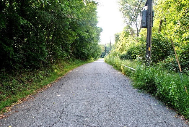
The dirt road will lead you to the Horseshoe Trail road and directly across the street is the Valley Forge Mountain Swim Club. This section of the Horseshoe Trail is paved for a distance.

You'll pass Horseshoe Pointe Drive along the way.

 |
| Looking west on Horseshoe Trail |
I'm not sure if this is what this sign is about but I found some information in the meeting minutes from the Schuylkill Township Board of Supervisors in regards to a request to build an amateur radio antennae on Valley Forge Mountain.


The paved Horseshoe Trail will then cross over Country Club and Clothier Springs Roads.


I ended up getting turned around in this area but it was by my own doing. I saw the below sign and walked past it, continuing on to the end of this section of the paved Horseshoe Trail. After turning around, I realized my mistake and kept moving. Once the Horseshoe Trail cuts to the south is where the unpaved Horse-Shoe Trail continues to the west.


The next roads you'll cross over are Chautauqua Trail and Wheelock Lane

I've had plans to explore the Diamond Rock Preserve but what I didn't know was that the Horse-Shoe Trail cuts right through the middle of it. Beginning in 1939, the Open Land Conservancy has protected approximately 482 acres of land from development in the Great Valley area.


Once you get to the western edge of the Diamond Rock Preserve, the Horse-Shoe Trail takes a turn to the northwest. Once you reach Howell Road, the trail then turns back to the west again.

 |
| Looking west on Howell Road |
The Horse-Shoe Trail then takes another turn off Howell Road to the northwest, then southwest, then northwest again alongside Rees Road.


The trail then crosses over Blackstone Road, still heading northwest.

A short distance after you cross over Blackstone Lane, you'll cross over Rees Road and into the woods across the street for a short distance.

The next road you'll get to is White Horse Road. Cross over the street and from there, the trail cuts through the woods alongside the road heading northeast.


Once you get to the corner of White Horse and Union Hill Roads, the trail turns again to the northwest.

Union Hill Road was probably one of the tougher challenges of the hike other than walking through Valley Forge. The hill there was a bit on the steep side and it was long.

 |
| Passing Tinker Hill Lane along the way |
Union Hill Road turns to the north, then makes another turn back to the northwest. Once it turns back to the northwest, the Horse-Shoe Trail then turns off the road heading to the west.

The Thompson Trail shoots off the Horse-Shoe Trail at Union Hill heading north and leads to Tinker Hill Road somewhere around the Graham Road area. With this one hike, I've now found two more places to check out on another day!

The Horse-Shoe Trail changes directions a few times after turning off Union Hill Road.


 |
| Crossing over an old set of railroad tracks along the Horse-Shoe Trail |
The trail will then lead you to Aldham Road and turns to the southwest.

Follow Aldham Road until you get to State Road (State Route 29). Directly across the street from there is Hollow Road and a very short distance from there is the Great Valley Nature Center.


At the Great Valley Nature Center, I stopped at a bench directly across the creek from the parking lot to take a break and get a bite to eat.


Intersection of State Road and Hollow Road. When I hiked the Horse-Shoe Trail from the Great Valley Nature Center to the Brightside Farm, I made note that I couldn't find the Horse-Shoe trail while exploring the nature center. The reason for this is that it doesn't cut through the nature center, it follows Hollow Road until it turns off right around here.
Note that if you'd like to check out the Thompson Trail, there's a small place to park on the eastern side of State Road. You could also park at the Great Valley Nature Center if you don't mind crossing over State Road which can be busy at times.

On my return to Valley Forge, I didn't take too many pictures. This is the view looking back towards the nature center on Aldham Road.

A few weeks ago, I mentioned that I have a bad habit of losing my towels while hiking. During my hike, my shoulder started to hurt a bit from my backpack so I made an adjustment to it. Apparently, when I made that adjustment, my towel also decided to jump off. Thankfully (sort of), it was hot outside so I noticed within a few minutes and was able to backtrack and pick it up.
While I'm mentioning it being hot outside, here's a small tidbit of information/word of caution. On my return hike back to Valley Forge and even though I was sweating from the heat, I started getting the chills which means my body was feeling the effects of heat stress. Heat stress is caused by a number of factors. For starters, hot and humid weather reduces the ability for the body to cool itself down, sweating depletes the salt in your body, wearing a hat prevents heat from escaping from your head, and dehydration, just to name a few.
I always wear a hat to keep the sun out of my eyes and any arachnids from finding a home in my scalp (the hat is treated with permethrin). While I'm hiking and if I start to get hot, I do take it off which I did when I started getting the chills. I also didn't eat any snacks that had any salt in them so this could have also contributed to the problem, and I'm pretty sure I had enough water with me although I did run out before getting back to Valley Forge. Thankfully, there are water fountains at the park!
Lesson learned, if you ever start to get the chills when you're sweating, especially on a hot and humid day, listen to your body, stop and take a rest to let it cool down some, preferably in a shady spot.
 |
| Dropped my towel again, at least I found and recovered it this time! |

On my way to the Great Valley Nature Center, I walked right past the Wharton Esherick Museum without even realizing it. I've been aware of this museum for a while and knew it was alongside the Horse-Shoe Trail and when I walked past it, noticed the parking spaces and a wooden walkway leading to the building, I just didn't know this was it. I'll eventually check it out but for the cost ($15) and needing to make a reservation, I didn't want to do this during a hike.

 |
| Grapes anyone? |
That was about it for my hike on the Horse-Shoe Trail for the day. I think the next time I hit this trail, I'll be a little more careful about how far I decide to hike on such a hot day. I've been hiking in the heat all summer long and this is the first time I ended up getting the chills. This was also my longest hike of the season so I picked a heck of a day to hike this far. By the end, my feet were feeling every step and any hill I had to climb became quite the project.
In all, it was a good hike that I'd definitely do again. The difference with the Horse-Shoe Trail and hiking at preserves, state parks, etc., is that you're walking on roads and you're never far from private property. It's not really my style when it comes to hiking since I prefer being more secluded but it's still a pretty fun adventure.
Until next time, happy exploring and happy hiking!
Please give my Facebook page a like!
No comments:
Post a Comment