Date of Hike: Sunday, October 11, 2015
Total Distance: 13.59 Miles
Avg speed: 2.2 MPH
Total Time: 6:6:43
Conditions: Sunny, 68 Degrees
Difficulty: Easy, Moderate
On Sunday, October 11, I took another ride out to St. Peters Village, this time to head in the opposite direction on the Horse-Shoe Trail than I had gone the last time I was there. Technically, it wasn't the last time I was at St. Peters Village. On October 2, I hiked this same route to test out my waterproof gear which turned out to be a complete fail. My "supposed to be" waterproof jacket, pants, and boots were all soaked through by the time I returned to my car. I'm glad it was chilly that day and the layers I was wearing underneath kept me from getting completely soaked or it could have been a pretty miserable and cold hike. By the time I had returned to my car, I was starting to get cold even though I was moving at a decent pace.
Like usual, I parked in the same parking lot I always do when I go to St. Peters Village.
Approximate address for parking is:
3100 St. Peters Road
Elverson, PA 19520
GPS: 40.181211, -75.730608

The fall colors are really starting show over the last week and a half or so. These trees are just on the edge of the parking lot.


Once you cross over the bridge from the parking lot, you have a choice on which direction to go. If you turn to the left, this trail will bring you down to the boulders and the Falls at French Creek. If you go to the right, you'll be crossing over Mine Run and headed towards the old train trestle. If you go straight (southwest), this is the connecting trail that will bring you to the Horse-Shoe Trail and was the direction I went. If you'd like to see more of St. Peters, click here. I did not head to the rocks or the train trestle since I already had my objective in mind.

I have to echo the sentiments of whoever posted this sign. I've previously stated that St. Peters was one of my favorite places to go when I needed some "down time". Shamefully and due to its popularity, I've not only seen trash scattered all over the place, but there's also a LOT of graffiti. So much so that you really can't go anywhere within St. Peters and not find it. Since my visit last year, I've begun to avoid the more popular areas because it upsets me to see such a beautiful place being ruined by ignorance.

Ok, I'm off my soap box. Back to hiking! If you're looking to hike the Horse-Shoe Trail in either direction, follow the light blue trail markers to the south.

There are a few side trails that head off in different directions from the blue blazed connecting trail. Don't let them confuse you and keep going straight.


The connecting blue trail gradually makes a turn to the southwest where it intersects with the Horse-Shoe Trail. I had taken a picture of where the trails intersect but it came out blurry. If you want to head towards Welkinweir, you want to turn left (southeast). If you want to head to Hopewell Furnace, veer to the right heading southwest.


Once you're on the Horse-Shoe Trail, you'll be climbing a hill for a good distance. It's not steep but it's long enough that you'll be warmed up by the time you reach the top.

The Horse-Shoe Trail is well marked in this area as it has been in all of the different sections that I've hiked so far. Quite honestly and although I brought it with me, I don't really think you'd need a trail map. I always bring a map just in case though, you never know when you may need it!


The Horse-Shoe Trail then makes a turn to the west, then to the northeast and eventually turns to the north until you end up alongside Mine Run. Just off the trail is this metal contraption. What it is, I have no idea but it's heavy. St.Peters was once known for its mining operations as well as the quarries in the area, I have to wonder if whatever this contraption was at one time was used during that period.

Once you get to Mine Run, the trail takes another turn to the west and is the direction you'll be going for a good distance.

At first, I thought these markers were graffiti but as I kept hiking the Horse-Shoe Trail, I noticed numerous trees alongside the trail to the south were marked, all of them within about 10-15 feet from the trail. Trail markers for the Horse-Shoe Trail are yellow, I have to wonder what these white markers represented, perhaps signifying private property?

The first road crossing you'll get to is Trythall Road. Once you cross over Trythall Road, you'll be entering the Warwick Woods Campground.

This was the first of three of these caterpillars I spotted during my hike. Known as a Hickory Tussock Caterpillar, their hairs can cause an burning and/or itchy rash on some, sometimes swelling and nausea in those who may be more sensitive. Look but don't touch!
I noted above that the temperature was 68 degrees which was the high for the day. When I first started my hike, the temperature was in the high 30's/lower 40's and the ground was still very wet. This caterpillar was barely moving when I spotted it and as you can see, it still had morning dew on it as well.

This section of the Horse-Shoe Trail are the remnants of a railroad known as the Warwick Branch that once served the black granite quarry (or quarries?) and mines at St. Peters Village. This railroad ran from St. Peters Village to Elverson and was a branch of the Wilmington Division of the Philadelphia and Reading Railroad. It's unknown when the railroad was abandoned.

The Horse-Shoe Trail runs along the southern end of the Crow's Nest Preserve

Once you get past Warwick Woods Campground, the Horse-Shoe Trail takes a slight turn to the west. Make sure you keep your eyes open for this turn, the post/trail marker for the Horse-Shoe Trail is broken and was leaning against a rock. When I hiked through this area on October 2 during the rain, it was on the ground and I almost walked right past it.


The Horse-Shoe Trail then takes another turn to the north.

This is the only stream crossing without a bridge in this section of the Horse-Shoe Trail (Mine Run, the same one that also cuts through St. Peters). When I hiked the trail on October 2, it was flooded to the point where only a few of the rocks you see were above water. Had it been raining harder than it was, I might have turned back at this point.


Shortly after crossing over Mine Run, you'll be entering into the eastern section of State Game Lands #43. I know I say this a lot but I can't stress it enough. You're entering into game lands and it's currently hunting season so be sure to wear safety gear (bright orange) so that hunters will recognize you as human. Even though I hiked through here on a Sunday when hunting isn't permitted, I still wore my safety gear. Better safe than sorry!


As you're walking through the game lands, you'll also see a few other side trails heading off in different directions. Make sure you keep an eye on the markers for the Horse-Shoe Trail so that you don't make a wrong turn. You won't be able to miss them, they're all over the place.

The next street you'll cross over will be Northside Road, still heading in a northerly direction.


This section of the Horse-Shoe Trail cuts along the edge of some grasslands.


The Horse-Shoe Trail then takes a slight left turn back into the woods after skirting along the edge of the grasslands for a distance.

Before making my turn back into the woods, I took a short detour along the edge of the grasslands to take a picture of the fall colors which are beginning to look quite brilliant!


The next street you'll get to is Harmonyville Road which is one of the few in this section of the Horse-Shoe Trail where you'll actually be walking alongside the road for a short distance.


Once you're on Harmonyville Road, you'll be headed in a northwest direction, then turning to the west.

The trail then takes a slight left turn back onto grasslands and continues to follow Harmonyville Road for a short distance.


The Horse-Shoe Trail then takes another turn to the Northeast, crossing over Harmonyville Road and running parallel with Bethesda Road where you'll be walking alongside some open grasslands again.


The Horse-Shoe Trail then takes another turn to the northwest, crossing over Bethesda Road and following the only road you'll be hiking on for more than a short distance, Green Lane.

Last year when I went camping at French Creek State Park, I took Green Lane to return to the campsite after hiking nearby (I think I was at Crow's Nest Preserve that day) which was almost a mistake. Green Lane is a dirt road and in areas is washed out with low spots. In an SUV or truck, no big deal but if you're driving a car, it would be best to avoid driving through here.

Once you reach the end of Green Lane, the next road crossing is State Route 345, or Pine Swamp Road.

Once you cross over Pine Swamp Road, you'll be entering the property of Hopewell Furnace National Historical Site. The Horse-Shoe Trail takes a turn to the west, then to the north.


As I was walking along the trail, I looked to the west and spotted these rocks. This is one of those times where pictures just don't convey what the eyes see. The hill these rocks are on is quite steep and the rocks seem to extend for quite a distance. I was tempted to climb the hill just to see how far the rocks went but since I already had my objective in mind, I decided to wait until another time. It won't take much convincing to get me to return!


Now heading in a northwesterly direction, getting close to Hopewell Furnace

Before I headed to Hopewell Furnace, I took a detour into French Creek State Park to check out Hopewell Lake. Signs of fall are everywhere! Last year, I stopped hiking around this time (actually it was sooner than this) due to plantar fasciitis in my left foot so I didn't get to enjoy the colors as much as I can this year.


Once I was done checking out the fall colors on Hopewell Lake, I turned back to head towards Hopewell Furnace.

I was now entering the main part of Hopewell Furnace National Historic Site. Founded in 1771 by ironmaster Mark Bird, the furnace was in operation until 1883.

There was no information about what was once here but you can see that these are the remnants of something. Was it a home? Part of the furnace?

Giving my interest in historical places, I have to warn you now, I took a lot of pictures at Hopewell Furnace. I couldn't help it, I was fascinated by what I saw!

I posted similar pictures to these on Facebook after my last hiking adventure to Hopewell Furnace on October 2 and returned to the same building to take a few more.


During its entire 112 years in operation, African-Americans played an important role in the iron making industry at Hopewell Furnace. At first, the builder of the furnace, Mark Bird, owned a total of 18 slaves (10 men, 4 women, 3 boys and 1 girl) and was the largest slave owner in Berks County. These slaves were said to have dug the original headrace that turned the water wheel supplying air to the furnace.
In 1780, even though state assembly passed an act ordering gradual emancipation, African-Americans continued to work at Hopewell, some of which spent their entire lives at the furnace in one role or another. Beginning in 1835, the remote area around Hopewell played an important role in the Underground Railroad movement with many of the former slaves earning their living working in the iron industry as woodcutters, colliers, and teamsters.


The supply of iron ore that the Hopewell Furnace depended on was taken from three mines located within a few miles of the furnace. At first, all of the mines were an open pit process but as mining technology advanced, some of the mines started shaft operations. The ore that was mined from these locations was 40% to 50% iron.


The miners themselves were the laborers who supplied Hopewell Furnace with the iron ore it needed to stay in operation. Most of the miners were men and young boys although records indicate that women may have worked at the mines as well. The amount of iron ore the miners extracted determined how much their monthly earnings were, ranging from $11.33 -$21.00 per month from 1825-1827.


Hopewell Furnace played a role in defending the country during the revolutionary war, producing 115 cannon, some of which were used on the frigate Randolph and gunboat Delaware. The furnace also supplied shot and shell to the Continental Army and Navy as well as 10 inch mortar shells that were used to help win the final major battle of the war at Yorktown, Virginia.


On the bottom right of the below picture, there are what I believe to be channels where pig iron was once produced. Molten iron flowed from the furnace's tap hole into the compressed sand in the floor which became known as pigs since they resembled a sow nursing its piglets. Once cooled, the pig iron was sold to other forges and foundries for further processing. Hopewell Furnace mainly produced pig iron during the last 40 years in operation.


The water wheel at Hopewell Furnace was used to force compressed air into the furnace in order to intensify heat to melt the iron, a temperature above 2800 degrees. Prior to 1822, blast bellows were used to push air into the furnaces.
Originally (1771) the water wheel was a 30 foot overshot which was replaced in 1805 by a 22 foot breast wheel due to the furnace losing rights to the west headwater (not sure what this means). It was at that time Hopewell Dam was built to provide a new source of water power to the furnace. Since 1805, the water wheel has been replaced or repaired several times. The current water wheel was dedicated on August 5, 2006 and is made of mostly chestnut and oak.
A breast wheel is commonly found in areas where the headwater (water supply) is between 5 and 12 feet high and gets its name due to the water flowing in half way up the wheel whereas an overshot wheel gets its water supply from the top, and an undershot wheel getting its supply from underneath,

From 1822 on, the water wheel supplied compressed air using blowing tubs that were piston driven. From the blowing tubs, the air was pushed into a receiving box that was between the tubs, then through a long pipe and into the furnace through a cone shaped nozzle attached to the end of the pipe, known as a tuyere.


Prior to its last 40 years in operation, Hopewell Furnace also produced finished products such as stove plates, hollowware, weights and other molded items.


Once I was done checking out the water wheel for the time being, I walked around the back of the building to get a closer look at the side of it. Note that if you decide to walk back to this area that it's quite soggy. The water flowing into the water wheel flows through a wooden channel (seen on the left) leaks onto the ground and flows into this area.


If any teachers would like to bring their students to Hopewell Furnace for an educational program, they are offered to schools on Wednesdays, Thursdays and Fridays during the school year. Maybe I can pretend to be a teacher for a day, I'd love to attend this myself!


As I was walking through one of the buildings, I heard a tapping above my head. I look up and spot this downy woodpecker tapping away at this mud wasp nest.


The land at Hopewell Furnace was also used for farming. When in use, the barn that the below sleighs and other carriages are now in was used for the horses and mules that hauled materials to the furnace and finished product to the market. This is the upper level of the barn where hay was stored, the lower level was where the horses and mules were stabled.

A shovel plow was used to create a "furrow" or ditch in already cultivated soil where potatoes and similar crops would be planted. Once planted, the plow could be used to backfill the furrows to build a mound that the plants would grow on. Unfortunately, this isn't the best picture since it doesn't show the actual shovel portion of this tool.

To bring nutrient rich soil to the surface, the moldboard plow's curved shape blade would cut furrows into the ground, turning the soil over. During the early 1800's, Hopewell Furnace produced cast iron blades for tools like what you see below.

Unfortunately, I didn't get any information on the carriages while I was there but I believe they were used to transport charcoal to the furnace while it was in operation.


The hired girls/women did the Big House wash in this building and in the fall, they boiled cider and apple butter in a copper kettle. When hogs and cattle were butchered, the meat and fat were boiled in an iron kettle for scrapple, liver pudding and sausage stuffing.


I didn't take a picture but to the right side past the above opening, there was an oven that was used for baking goods such as pastries and bread.
This is a meal shed where bulk grain and meal were kept for purchase by the Hopewell Furnace workers. Nearby mills would grind into meal or flour the corn, buckwheat, oats and rye that was raised on the furnace lands.


I circled back to the upper section of the wheel house.

Known as fillers, workers would unload charcoal, iron and limestone into the furnace's tunnel head (the open grate) and a furnace worker or founder would control the quality of the iron by varying the amounts of iron ore, limestone, charcoal and air blast from the water wheel's bellows.

Although its not the best view, from above, you can see the blowing tubs and equalizing box that was powered by the water wheel below them.


I'm not sure what it's called but the trough to the left is where the water is flowing to feed the water wheel.

The building closer to the forefront is the meal shed and Buckley & Brooke Office and Store. The building towards the back is the barn where the carriages and farming equipment are. I believe horses are also still kept in the lower section of the barn, the smell as you got close was quite ripe.

Wagonloads of hot, newly made charcoal were brought to a cooling shed by teamsters. Once the charcoal had cooled, it was then moved and piled inside a stone storage house.


A hot blast anthracite furnace was built at Hopewell in 1853. Instead of burning charcoal like the earlier furnaces, anthracite coal was used to smelt the iron. However, the anthracite furnace at Hopewell was only in operation for less than four years and by 1857, the furnace machinery was moved and installed in a new furnace on the Schuylkill Canal.


An attempt was made for a new method of creating charcoal using brick ovens or kilns instead of the older method you'll see below. While the brick kilns produced charcoal, the method proved to be unsuccessful. All that remains of the kiln is what you see below.

In a number of my previous posts, I've spoken about charcoal hearths, also known as charcoal pits. The process for creating a charcoal hearth was first, a long pole known as a fagan was driven into the ground, then a three corner chimney was built using small cuts of wood known as lapwood.
The next step was to stack larger pieces of wood known as billets against the chimney, eventually building a lower and upper tier. Once enough of the billets were in place, the open spaces left by the billets were covered with more lapwood. Normally, a charcoal hearth was about 30-40 feet wide.
The next step was to cover the entire pit with leaves and charcoal dust (and/or dirt) and to light the pit from the chimney at the top. The process of creating the charcoal would take anywhere from ten days to two weeks. The best charcoal for Hopewell was made using chestnut, oak and hickory.

Charcoal was made during the spring, summer and fall and keeping an eye on the hearths was the job of what's known as a collier who would oversee a number of them at the same time. Giving the job as a collier was a 24 hour a day operation, cone shaped huts were built where they would live while tending to the hearths.


As mentioned above, this is the outer part of a charcoal cooling shed where the hot coals were stored until they cooled enough to be stored inside the building opposite of this carriage.


Admiring the fall colors from a distance with the meal shed in the forefront and barn to the left.

Almost done with my tour of Hopewell Furnace, I started heading back in the direction of the Horse-Shoe Trail and St. Peters Village.


Most of what you've seen is north of the section of the Horse-Shoe Trail I was on. Walking past the trail to the south were a few more smaller buildings, likely homes for those who worked at the furnace.


While there's no official records, the above building was thought to be a boarding house for single men or those who were living away from their families.

Just behind the boarding house were a few steers grazing in the field.


That was it for my tour of Hopewell Furnace and to say I had a blast checking this place out would be an understatement. I hope you enjoy it as much as I did. I was now on my return back to St. Peters Village


Now back at St. Peters, this is the former Warwick Branch railroad crossing over Mine Run just to the east of where the Horse-Shoe Trail makes a turn to the southeast.

This is probably the strangest group of fungus I've ever seen. Each of them seem to be a different type


That was it for my adventure on this section of the Horse-Shoe Trail for the day. As I mentioned, I had made this same hike on October 2 but was unable to take many pictures due to the rain. Once I got closer to the more popular section of St. Peters, I stopped taking pictures for reasons that I mentioned at the beginning of this post.
In all and being a bit of a history nut, I found this hike to be awesome! Would I do this again? Absolutely. This is another area where I'd love to return during the winter to see if there are any ruins being shrouded by the leaves from trees, not to mention the historical side of the hike.
Until next time, happy exploring and happy hiking!
Please give my Facebook page a like!
On Sunday, October 11, I took another ride out to St. Peters Village, this time to head in the opposite direction on the Horse-Shoe Trail than I had gone the last time I was there. Technically, it wasn't the last time I was at St. Peters Village. On October 2, I hiked this same route to test out my waterproof gear which turned out to be a complete fail. My "supposed to be" waterproof jacket, pants, and boots were all soaked through by the time I returned to my car. I'm glad it was chilly that day and the layers I was wearing underneath kept me from getting completely soaked or it could have been a pretty miserable and cold hike. By the time I had returned to my car, I was starting to get cold even though I was moving at a decent pace.
Like usual, I parked in the same parking lot I always do when I go to St. Peters Village.
Approximate address for parking is:
3100 St. Peters Road
Elverson, PA 19520
GPS: 40.181211, -75.730608

The fall colors are really starting show over the last week and a half or so. These trees are just on the edge of the parking lot.


 |
| Looking downstream on French Creek from the bridge next to the parking lot |
Once you cross over the bridge from the parking lot, you have a choice on which direction to go. If you turn to the left, this trail will bring you down to the boulders and the Falls at French Creek. If you go to the right, you'll be crossing over Mine Run and headed towards the old train trestle. If you go straight (southwest), this is the connecting trail that will bring you to the Horse-Shoe Trail and was the direction I went. If you'd like to see more of St. Peters, click here. I did not head to the rocks or the train trestle since I already had my objective in mind.

I have to echo the sentiments of whoever posted this sign. I've previously stated that St. Peters was one of my favorite places to go when I needed some "down time". Shamefully and due to its popularity, I've not only seen trash scattered all over the place, but there's also a LOT of graffiti. So much so that you really can't go anywhere within St. Peters and not find it. Since my visit last year, I've begun to avoid the more popular areas because it upsets me to see such a beautiful place being ruined by ignorance.

Ok, I'm off my soap box. Back to hiking! If you're looking to hike the Horse-Shoe Trail in either direction, follow the light blue trail markers to the south.

There are a few side trails that head off in different directions from the blue blazed connecting trail. Don't let them confuse you and keep going straight.


The connecting blue trail gradually makes a turn to the southwest where it intersects with the Horse-Shoe Trail. I had taken a picture of where the trails intersect but it came out blurry. If you want to head towards Welkinweir, you want to turn left (southeast). If you want to head to Hopewell Furnace, veer to the right heading southwest.


Once you're on the Horse-Shoe Trail, you'll be climbing a hill for a good distance. It's not steep but it's long enough that you'll be warmed up by the time you reach the top.

The Horse-Shoe Trail is well marked in this area as it has been in all of the different sections that I've hiked so far. Quite honestly and although I brought it with me, I don't really think you'd need a trail map. I always bring a map just in case though, you never know when you may need it!


 |
| The Horse-Shoe Trail making a turn to the north, then northeast |

The Horse-Shoe Trail then makes a turn to the west, then to the northeast and eventually turns to the north until you end up alongside Mine Run. Just off the trail is this metal contraption. What it is, I have no idea but it's heavy. St.Peters was once known for its mining operations as well as the quarries in the area, I have to wonder if whatever this contraption was at one time was used during that period.

 |
| Looking upstream on Mine Run just next to the above contraption |
Once you get to Mine Run, the trail takes another turn to the west and is the direction you'll be going for a good distance.

At first, I thought these markers were graffiti but as I kept hiking the Horse-Shoe Trail, I noticed numerous trees alongside the trail to the south were marked, all of them within about 10-15 feet from the trail. Trail markers for the Horse-Shoe Trail are yellow, I have to wonder what these white markers represented, perhaps signifying private property?

The first road crossing you'll get to is Trythall Road. Once you cross over Trythall Road, you'll be entering the Warwick Woods Campground.

This was the first of three of these caterpillars I spotted during my hike. Known as a Hickory Tussock Caterpillar, their hairs can cause an burning and/or itchy rash on some, sometimes swelling and nausea in those who may be more sensitive. Look but don't touch!
I noted above that the temperature was 68 degrees which was the high for the day. When I first started my hike, the temperature was in the high 30's/lower 40's and the ground was still very wet. This caterpillar was barely moving when I spotted it and as you can see, it still had morning dew on it as well.

 |
| Small fishing pond at Warwick Woods Campground |
This section of the Horse-Shoe Trail are the remnants of a railroad known as the Warwick Branch that once served the black granite quarry (or quarries?) and mines at St. Peters Village. This railroad ran from St. Peters Village to Elverson and was a branch of the Wilmington Division of the Philadelphia and Reading Railroad. It's unknown when the railroad was abandoned.

The Horse-Shoe Trail runs along the southern end of the Crow's Nest Preserve

Once you get past Warwick Woods Campground, the Horse-Shoe Trail takes a slight turn to the west. Make sure you keep your eyes open for this turn, the post/trail marker for the Horse-Shoe Trail is broken and was leaning against a rock. When I hiked through this area on October 2 during the rain, it was on the ground and I almost walked right past it.


The Horse-Shoe Trail then takes another turn to the north.

This is the only stream crossing without a bridge in this section of the Horse-Shoe Trail (Mine Run, the same one that also cuts through St. Peters). When I hiked the trail on October 2, it was flooded to the point where only a few of the rocks you see were above water. Had it been raining harder than it was, I might have turned back at this point.


Shortly after crossing over Mine Run, you'll be entering into the eastern section of State Game Lands #43. I know I say this a lot but I can't stress it enough. You're entering into game lands and it's currently hunting season so be sure to wear safety gear (bright orange) so that hunters will recognize you as human. Even though I hiked through here on a Sunday when hunting isn't permitted, I still wore my safety gear. Better safe than sorry!


As you're walking through the game lands, you'll also see a few other side trails heading off in different directions. Make sure you keep an eye on the markers for the Horse-Shoe Trail so that you don't make a wrong turn. You won't be able to miss them, they're all over the place.

The next street you'll cross over will be Northside Road, still heading in a northerly direction.


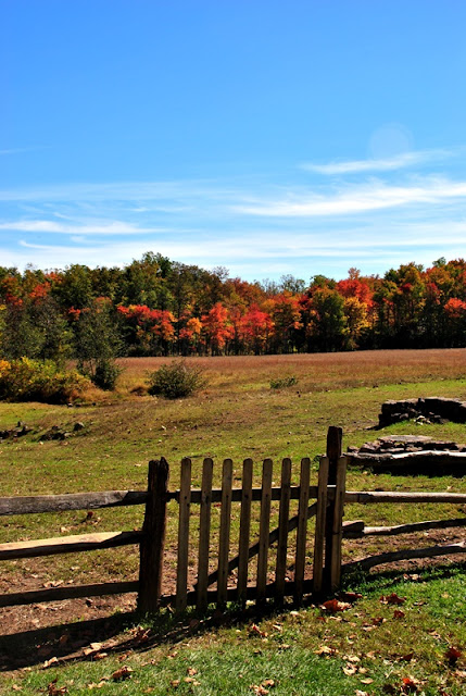
This section of the Horse-Shoe Trail cuts along the edge of some grasslands.


The Horse-Shoe Trail then takes a slight left turn back into the woods after skirting along the edge of the grasslands for a distance.

Before making my turn back into the woods, I took a short detour along the edge of the grasslands to take a picture of the fall colors which are beginning to look quite brilliant!


The next street you'll get to is Harmonyville Road which is one of the few in this section of the Horse-Shoe Trail where you'll actually be walking alongside the road for a short distance.


Once you're on Harmonyville Road, you'll be headed in a northwest direction, then turning to the west.

 |
| Pine Run looking upstream from the bridge on Harmonyville Road |
The trail then takes a slight left turn back onto grasslands and continues to follow Harmonyville Road for a short distance.


The Horse-Shoe Trail then takes another turn to the Northeast, crossing over Harmonyville Road and running parallel with Bethesda Road where you'll be walking alongside some open grasslands again.


The Horse-Shoe Trail then takes another turn to the northwest, crossing over Bethesda Road and following the only road you'll be hiking on for more than a short distance, Green Lane.

Last year when I went camping at French Creek State Park, I took Green Lane to return to the campsite after hiking nearby (I think I was at Crow's Nest Preserve that day) which was almost a mistake. Green Lane is a dirt road and in areas is washed out with low spots. In an SUV or truck, no big deal but if you're driving a car, it would be best to avoid driving through here.

Once you reach the end of Green Lane, the next road crossing is State Route 345, or Pine Swamp Road.

Once you cross over Pine Swamp Road, you'll be entering the property of Hopewell Furnace National Historical Site. The Horse-Shoe Trail takes a turn to the west, then to the north.


As I was walking along the trail, I looked to the west and spotted these rocks. This is one of those times where pictures just don't convey what the eyes see. The hill these rocks are on is quite steep and the rocks seem to extend for quite a distance. I was tempted to climb the hill just to see how far the rocks went but since I already had my objective in mind, I decided to wait until another time. It won't take much convincing to get me to return!


Now heading in a northwesterly direction, getting close to Hopewell Furnace

Before I headed to Hopewell Furnace, I took a detour into French Creek State Park to check out Hopewell Lake. Signs of fall are everywhere! Last year, I stopped hiking around this time (actually it was sooner than this) due to plantar fasciitis in my left foot so I didn't get to enjoy the colors as much as I can this year.


Once I was done checking out the fall colors on Hopewell Lake, I turned back to head towards Hopewell Furnace.

I was now entering the main part of Hopewell Furnace National Historic Site. Founded in 1771 by ironmaster Mark Bird, the furnace was in operation until 1883.

There was no information about what was once here but you can see that these are the remnants of something. Was it a home? Part of the furnace?

Giving my interest in historical places, I have to warn you now, I took a lot of pictures at Hopewell Furnace. I couldn't help it, I was fascinated by what I saw!

I posted similar pictures to these on Facebook after my last hiking adventure to Hopewell Furnace on October 2 and returned to the same building to take a few more.


During its entire 112 years in operation, African-Americans played an important role in the iron making industry at Hopewell Furnace. At first, the builder of the furnace, Mark Bird, owned a total of 18 slaves (10 men, 4 women, 3 boys and 1 girl) and was the largest slave owner in Berks County. These slaves were said to have dug the original headrace that turned the water wheel supplying air to the furnace.
In 1780, even though state assembly passed an act ordering gradual emancipation, African-Americans continued to work at Hopewell, some of which spent their entire lives at the furnace in one role or another. Beginning in 1835, the remote area around Hopewell played an important role in the Underground Railroad movement with many of the former slaves earning their living working in the iron industry as woodcutters, colliers, and teamsters.


The supply of iron ore that the Hopewell Furnace depended on was taken from three mines located within a few miles of the furnace. At first, all of the mines were an open pit process but as mining technology advanced, some of the mines started shaft operations. The ore that was mined from these locations was 40% to 50% iron.


The miners themselves were the laborers who supplied Hopewell Furnace with the iron ore it needed to stay in operation. Most of the miners were men and young boys although records indicate that women may have worked at the mines as well. The amount of iron ore the miners extracted determined how much their monthly earnings were, ranging from $11.33 -$21.00 per month from 1825-1827.


Hopewell Furnace played a role in defending the country during the revolutionary war, producing 115 cannon, some of which were used on the frigate Randolph and gunboat Delaware. The furnace also supplied shot and shell to the Continental Army and Navy as well as 10 inch mortar shells that were used to help win the final major battle of the war at Yorktown, Virginia.


On the bottom right of the below picture, there are what I believe to be channels where pig iron was once produced. Molten iron flowed from the furnace's tap hole into the compressed sand in the floor which became known as pigs since they resembled a sow nursing its piglets. Once cooled, the pig iron was sold to other forges and foundries for further processing. Hopewell Furnace mainly produced pig iron during the last 40 years in operation.


The water wheel at Hopewell Furnace was used to force compressed air into the furnace in order to intensify heat to melt the iron, a temperature above 2800 degrees. Prior to 1822, blast bellows were used to push air into the furnaces.
Originally (1771) the water wheel was a 30 foot overshot which was replaced in 1805 by a 22 foot breast wheel due to the furnace losing rights to the west headwater (not sure what this means). It was at that time Hopewell Dam was built to provide a new source of water power to the furnace. Since 1805, the water wheel has been replaced or repaired several times. The current water wheel was dedicated on August 5, 2006 and is made of mostly chestnut and oak.
A breast wheel is commonly found in areas where the headwater (water supply) is between 5 and 12 feet high and gets its name due to the water flowing in half way up the wheel whereas an overshot wheel gets its water supply from the top, and an undershot wheel getting its supply from underneath,

From 1822 on, the water wheel supplied compressed air using blowing tubs that were piston driven. From the blowing tubs, the air was pushed into a receiving box that was between the tubs, then through a long pipe and into the furnace through a cone shaped nozzle attached to the end of the pipe, known as a tuyere.

 |
| Pipeline where the compressed air was pushed into the furnace |


Prior to its last 40 years in operation, Hopewell Furnace also produced finished products such as stove plates, hollowware, weights and other molded items.


Once I was done checking out the water wheel for the time being, I walked around the back of the building to get a closer look at the side of it. Note that if you decide to walk back to this area that it's quite soggy. The water flowing into the water wheel flows through a wooden channel (seen on the left) leaks onto the ground and flows into this area.


If any teachers would like to bring their students to Hopewell Furnace for an educational program, they are offered to schools on Wednesdays, Thursdays and Fridays during the school year. Maybe I can pretend to be a teacher for a day, I'd love to attend this myself!

 |
| One last look at the water wheel for the time being |


As I was walking through one of the buildings, I heard a tapping above my head. I look up and spot this downy woodpecker tapping away at this mud wasp nest.

 |
| One of the cannons produced during the Revolutionary War? |

 |
| Marker for the Horse-Shoe Trail |
The land at Hopewell Furnace was also used for farming. When in use, the barn that the below sleighs and other carriages are now in was used for the horses and mules that hauled materials to the furnace and finished product to the market. This is the upper level of the barn where hay was stored, the lower level was where the horses and mules were stabled.

A shovel plow was used to create a "furrow" or ditch in already cultivated soil where potatoes and similar crops would be planted. Once planted, the plow could be used to backfill the furrows to build a mound that the plants would grow on. Unfortunately, this isn't the best picture since it doesn't show the actual shovel portion of this tool.

To bring nutrient rich soil to the surface, the moldboard plow's curved shape blade would cut furrows into the ground, turning the soil over. During the early 1800's, Hopewell Furnace produced cast iron blades for tools like what you see below.

Unfortunately, I didn't get any information on the carriages while I was there but I believe they were used to transport charcoal to the furnace while it was in operation.


The hired girls/women did the Big House wash in this building and in the fall, they boiled cider and apple butter in a copper kettle. When hogs and cattle were butchered, the meat and fat were boiled in an iron kettle for scrapple, liver pudding and sausage stuffing.


 |
| I couldn't resist, I had to look inside the cabinet...there was nothing in there. |

 |
| Looking back to the building where the hired girls/women worked. |
 |
| Heading towards the Big House |
I didn't take a picture but to the right side past the above opening, there was an oven that was used for baking goods such as pastries and bread.
 |
| Not much of the Big House could be seen but this room. I took this picture from the outside as the door was locked |
This is a meal shed where bulk grain and meal were kept for purchase by the Hopewell Furnace workers. Nearby mills would grind into meal or flour the corn, buckwheat, oats and rye that was raised on the furnace lands.


I circled back to the upper section of the wheel house.

Known as fillers, workers would unload charcoal, iron and limestone into the furnace's tunnel head (the open grate) and a furnace worker or founder would control the quality of the iron by varying the amounts of iron ore, limestone, charcoal and air blast from the water wheel's bellows.

Although its not the best view, from above, you can see the blowing tubs and equalizing box that was powered by the water wheel below them.


I'm not sure what it's called but the trough to the left is where the water is flowing to feed the water wheel.

The building closer to the forefront is the meal shed and Buckley & Brooke Office and Store. The building towards the back is the barn where the carriages and farming equipment are. I believe horses are also still kept in the lower section of the barn, the smell as you got close was quite ripe.

Wagonloads of hot, newly made charcoal were brought to a cooling shed by teamsters. Once the charcoal had cooled, it was then moved and piled inside a stone storage house.


 |
| Another shot of the trough where water is feeding the water wheel inside |
 |
| I took a peek inside this shed too, there were fire hoses in there |
A hot blast anthracite furnace was built at Hopewell in 1853. Instead of burning charcoal like the earlier furnaces, anthracite coal was used to smelt the iron. However, the anthracite furnace at Hopewell was only in operation for less than four years and by 1857, the furnace machinery was moved and installed in a new furnace on the Schuylkill Canal.


An attempt was made for a new method of creating charcoal using brick ovens or kilns instead of the older method you'll see below. While the brick kilns produced charcoal, the method proved to be unsuccessful. All that remains of the kiln is what you see below.

In a number of my previous posts, I've spoken about charcoal hearths, also known as charcoal pits. The process for creating a charcoal hearth was first, a long pole known as a fagan was driven into the ground, then a three corner chimney was built using small cuts of wood known as lapwood.
The next step was to stack larger pieces of wood known as billets against the chimney, eventually building a lower and upper tier. Once enough of the billets were in place, the open spaces left by the billets were covered with more lapwood. Normally, a charcoal hearth was about 30-40 feet wide.
The next step was to cover the entire pit with leaves and charcoal dust (and/or dirt) and to light the pit from the chimney at the top. The process of creating the charcoal would take anywhere from ten days to two weeks. The best charcoal for Hopewell was made using chestnut, oak and hickory.

Charcoal was made during the spring, summer and fall and keeping an eye on the hearths was the job of what's known as a collier who would oversee a number of them at the same time. Giving the job as a collier was a 24 hour a day operation, cone shaped huts were built where they would live while tending to the hearths.


 |
| Well, I was hiking...here's a shot of the Horse-Shoe Trail heading into French Creek State Park |

As mentioned above, this is the outer part of a charcoal cooling shed where the hot coals were stored until they cooled enough to be stored inside the building opposite of this carriage.


Admiring the fall colors from a distance with the meal shed in the forefront and barn to the left.

Almost done with my tour of Hopewell Furnace, I started heading back in the direction of the Horse-Shoe Trail and St. Peters Village.


Most of what you've seen is north of the section of the Horse-Shoe Trail I was on. Walking past the trail to the south were a few more smaller buildings, likely homes for those who worked at the furnace.


While there's no official records, the above building was thought to be a boarding house for single men or those who were living away from their families.

Just behind the boarding house were a few steers grazing in the field.


 |
| Looking back towards the other smaller buildings. |
That was it for my tour of Hopewell Furnace and to say I had a blast checking this place out would be an understatement. I hope you enjoy it as much as I did. I was now on my return back to St. Peters Village

 |
| Section of the Horse-Shoe Trail on Green lane |

 |
| Back on Harmonyville Road and admiring the fall colors |


 |
| Another Hickory Tussock Caterpillar |
Now back at St. Peters, this is the former Warwick Branch railroad crossing over Mine Run just to the east of where the Horse-Shoe Trail makes a turn to the southeast.

 |
| Mine Run from the old railroad bridge |
This is probably the strangest group of fungus I've ever seen. Each of them seem to be a different type


 |
| Almost back to the parking lot! |
That was it for my adventure on this section of the Horse-Shoe Trail for the day. As I mentioned, I had made this same hike on October 2 but was unable to take many pictures due to the rain. Once I got closer to the more popular section of St. Peters, I stopped taking pictures for reasons that I mentioned at the beginning of this post.
In all and being a bit of a history nut, I found this hike to be awesome! Would I do this again? Absolutely. This is another area where I'd love to return during the winter to see if there are any ruins being shrouded by the leaves from trees, not to mention the historical side of the hike.
Until next time, happy exploring and happy hiking!
Please give my Facebook page a like!
I believe the white blazes on the trees you mention indicate the border of the state game lands, or the beginning of private property as you put it.
ReplyDelete