Date of Hike: Thursday, November 5, 2015
Total Distance: 13.37 Miles
Avg speed: 2.9 MPH
Total Time: 4:41:18
Conditions: Cloudy, 66 Degrees
Difficulty: Easy
On November 5th, I took a ride out to the Collegeville area to check out the Perkiomen Trail. I've had intentions of checking this trail out for some time but am not fond of hiking in straight lines, flat terrain, or paved surfaces so it hasn't been a top priority. To be clear, the Perkiomen Trail isn't paved in all areas but it is in some sections which you'll see in a moment.
The Perkiomen Trail is a total of 20 miles long and runs from Lower Perkiomen Valley Park in Oaks, PA to Green Lane Park in Green Lane, PA. Like my expeditions on the Horse-Shoe Trail, I didn't start at the beginning. Instead, I just picked a spot and went with it. With that being said and given the length, you can find parking in a number of places along the trail. Note that for Collegeville parking, it states that there's limited spaces available but the parking lot to access the trail is pretty large. Unless it's a busy weekend, you shouldn't have much trouble finding a spot.
It's not the best quality and you likely wouldn't need one for the Perkiomen Trail but if you want to bring a trail map with you, it can be found here.

I started my adventure in the parking lot of the Appalachian Brewing Company. The address is:
50 Third Avenue
Collegeville, PA 19426
GPS: 40.185428, -75.453508
Take note, there are two different "Third Avenues" in the Collegeville area, one of which is "3rd" and has a west and east section (technically, this is in Trappe, PA), and the other is spelled out "Third". Make sure you spell out "Third" or you could end up about a mile or so away from the trail. This isn't just with Google Maps either, I also checked Bing Maps and ended up with the same results. If this has any bearing on whatever GPS device you may use to get there, that part I don't know.

Once you cross over E. Main Street, you'll find this sign which explains some of the history surrounding the railroad that used to be where the current Perkiomen Trail is now. An extensive history of this railroad can be found here.

The area was still wet from the rain that fell earlier in the morning. During my hike, the rain started to fall again but it was only a drizzle and it didn't last.


Now called the Power House and currently an antique and flea market, the building in the background used to be a power plant for powering the overhead wires for a trolley that ran through Collegeville between 1893 and 1933. The concrete pillars you see in the forefront were used for unloading coal that powered the plant.

It's getting very late in the fall season but there were still some colors to be seen.

The Perkiomen Trail is very well defined and is easily wide enough that a vehicle could drive on it. As previously stated, this used to be an old railway so the trail was already there, the tracks just had to be removed. When this occurred, I unfortunately was unable to find out.

One of a few mile markers I spotted along the trail. I did spot a few others but if they're posted on a consistent basis, I didn't see them all!

This fungus was all over the place on these rocks and when cutting through this area, the air smelled of mold.


Looking back to the area I had just walked through. This was the spot where there was that smell of mold in the air. I think it was due to the moisture and rain we had not too long before the hike.


Less than a mile from the Appalachian Brewing Company, the Perkiomen Trail crosses over 1st Avenue (State Route 29). Note that this road can be pretty busy at times.

In 1708, the first dam was built along the Perkiomen Creek in order to power the Collegeville Mill. At the turn of the 20th century, the mill was converted to electricity. While the dam was no longer needed to power the mill, it remained as an emergency water supply and for recreational activities for another 100 years. Due to the deteriorating condition of the dam, it was finally removed in 2003.
Once the dam was removed, creek banks that had been under water for almost 300 years were exposed and susceptible to erosion and invasion by non-native plants. Between May 2005 and October 2006, 200 volunteers planted more than 1600 trees and shrubs native to Pennsylvania along over 92,000 square feet of stream bank in an effort to restore the habitat that had previously been under water.

My first view of the Perkiomen Creek. While the Perkiomen Trail runs alongside the creek, it's also far enough away that the view is mostly or completely blocked by trees. In some areas, the trail is simply too far away to see the creek at all.


Once you approach Bridge Street (State Route 113), you'll get your first unobstructed view of the Perkiomen Creek (if you start in Collegeville and head north like I did) as the trail cuts under the bridge crossing over the creek. This is the view from under the bridge looking downstream.

Once you cross under the bridge, you'll find one of parking lots that are alongside the Perkiomen Trail. The below address is posted at a kiosk next to the parking lot although I'm not exactly sure why. A company by the name of Rahn's Concrete is a short walk away but the parking lot itself is off Bridge Street.


Once you cross over Schoolhouse Run, the next place of interest that you'll find is the Pennsylvania Live Steamers. Established in 1946, the Pennsylvania Live Steamers Inc. is a non-profit, all volunteer organization dedicated to the preservation of the nation's railroads mechanical and engineering heritage.

Unfortunately, there's a sign posted stating to respect the property by not trespassing. I was hoping for a closer look but it seems Pennsylvania Live Steamers is a members-only organization. While walking past, I saw someone working on one of the trains which was small enough to sit on top of.


Just past Pennsylvania Live Steamers is this small park although I don't recall the name of it.

Alongside the Perkiomen Trail are a number of places where you can stop to get a refreshment or bite to eat.

While mostly going in a north/south direction, there are occasional turns in the trail. Just after passing the above park and restaurant, the trail makes a turn to the east.


This is the first of a few places where the Perkiomen Trail crosses over the creek.


This bridge is a good 40-50 above the creek which was a bit freaky to me since I'm not fond of heights. This is the view looking upstream.

Once you cross over the bridge, the trail makes a quick loop back to the west towards the creek.


Another trail to explore! As you approach the Perkiomen Creek after crossing the bridge, the Skippack Township Trail cuts to the north, eventually leading to Evansburg State Park.


I didn't take any pictures but once you get beyond the intersecting Skippack Township Trail, you cross over Graterford Road and one of the number of different sections of Central Perkiomen Valley Park. I'm not sure why but while you're on the Perkiomen Trail, access to the park itself is fenced off. Once you get beyond the fenced off area, there's another section of the park which has a parking lot and some side trails that may be worthy of checking out in the future.


Spotted this great blue heron hanging out on a tree alongside the creek.


This view is looking downstream from the second of three bridges crossing over the Perkiomen Creek.


After crossing over the bridge, you'll find another section and the headquarters of the Central Perkiomen Valley Park along with plenty of parking.

I decided to take a quick detour off the Perkiomen Trail to explore this area. I didn't walk through the whole park but I did cross over Plank Road to check out the Old Mill House.

Built around 1901, the Old Mill House is now used as a rental facility for events and looks relatively modern. I didn't take any pictures or go inside (not sure if it was open), but I did walk around the outside to get a view of the Perkiomen Creek.

This is really the only picture that I took of the Old Mill House. My guess is that at one time water used to flow through this section to power the milling operations. Previous to being called the Old Mill House, the property was being leased by Irvin Hauseman and was known as the Hauseman's Mill.
Purchased by Joseph Pawling in 1774, the building functioned as a grist mill on and off for over 100 years until a fire destroyed it in 1900. In 1910, the property was purchased by Dr. Hiran Rittenhouse Loux who rebuilt it as a summer retreat with his wife between 1910 and 1925 on the foundation of the remnants of the mill. It was at this time where it became known as the Old Mill House. In 1925, Loux sold the property where it passed through several owners until it was purchased by a politician known as Charles Smith in 1948.
On March 30, 1976, Montgomery County purchased the Old Mill House and surrounding property and the Central Perkiomen Valley Park was born.


Once I was done exploring the park, I continued on my way north towards Schwenksville. In this section of the trail, there wasn't a whole lot to see other than the remaining leaves on trees which were still colorful in some areas.


Along with a few restaurants and retail locations, the Perkiomen Trail also passes very close to private residences.


Somewhere in this area, the Perkiomen Trail crosses over West Skippack Pike (State Route 73)


Now walking into Schwenksville, you'll find Meadow Park. At 6.7 acres, it's not that large but provides locals with a pavilion, picnic tables, and a playground for kids along with a view of the Perkiomen Creek.


The trail then crosses over another stream named Mine Run and by now, I was almost at what I thought would be my objective.

This is the first of two bridges you'll be crossing once you reach East Park Avenue.

After crossing the first bridge, you'll have to cross East Park Avenue and from there you'll see the second bridge which crosses over the Perkiomen Creek for the third time (and final for this hike). As usual, my picture is crooked, the bridge isn't leaning!

At this point, I reluctantly turned around to head back to the car. The reason I had chosen this section of the Perkiomen Trail to explore first was because I had the intention of checking out Pennypacker Mills County Park. It turns out that there's no access to the park from this section of the Perkiomen Trail unless I wanted to walk a good distance alongside roads to get there.
Had I been a little more observant during my adventure, I believe I could have accessed the park by turning west on West Skippack Pike (State Route 73), then to Haldeman Road after crossing the Perkiomen Creek. What I don't recall is if there's a sidewalk along West Skippack Pike that would have allowed me to cross the bridge without being run over, Skippack Pike can be pretty busy at times. Looking at it from Google Maps, it seems there's enough space.

On the way back to the car, I took a few shots but for the most part, was on cruise control. I stopped a few times to rest the legs but otherwise, I kept moving. It's amazing how stopping those few brief seconds to take pictures can make such a big difference and give the legs a short rest. It allows you to walk further without getting tired. On my return, the legs let me know they weren't too happy with me!


That was it for my adventure on the Perkiomen Trail (for now). After returning to my vehicle, I dropped off the backpack and headed into the Appalachian Brewing Company to grab a bite to eat and a refreshment. The brewing company is big and very nice! If you get a chance, check it out.
I only covered a little more than 6.5 of the 20 miles of trail so I'll eventually be returning to complete the entire length but there's really no hurry to do so. I've mentioned this a number of times in my blog but I'm not keen on trails that are paved (or crushed stone), flat and straight since I eventually end up getting bored. In the Collegeville/Schwenksville areas, the trail also runs parallel to State Route 29 and with the exception of a few areas, traffic is usually within earshot.
Thankfully, walking on the Perkiomen Trail also takes you through some historic areas and there were still some nice fall colors to keep my interest peaked. I eventually plan on returning this section of the trail so I can make my way to Pennypacker Mills County Park (if it's possible).
Until next time, happy adventures and happy hiking!
On November 5th, I took a ride out to the Collegeville area to check out the Perkiomen Trail. I've had intentions of checking this trail out for some time but am not fond of hiking in straight lines, flat terrain, or paved surfaces so it hasn't been a top priority. To be clear, the Perkiomen Trail isn't paved in all areas but it is in some sections which you'll see in a moment.
The Perkiomen Trail is a total of 20 miles long and runs from Lower Perkiomen Valley Park in Oaks, PA to Green Lane Park in Green Lane, PA. Like my expeditions on the Horse-Shoe Trail, I didn't start at the beginning. Instead, I just picked a spot and went with it. With that being said and given the length, you can find parking in a number of places along the trail. Note that for Collegeville parking, it states that there's limited spaces available but the parking lot to access the trail is pretty large. Unless it's a busy weekend, you shouldn't have much trouble finding a spot.
It's not the best quality and you likely wouldn't need one for the Perkiomen Trail but if you want to bring a trail map with you, it can be found here.

 |
| Looking north from the parking lot of the Appalachian Brewing Company |
I started my adventure in the parking lot of the Appalachian Brewing Company. The address is:
50 Third Avenue
Collegeville, PA 19426
GPS: 40.185428, -75.453508
Take note, there are two different "Third Avenues" in the Collegeville area, one of which is "3rd" and has a west and east section (technically, this is in Trappe, PA), and the other is spelled out "Third". Make sure you spell out "Third" or you could end up about a mile or so away from the trail. This isn't just with Google Maps either, I also checked Bing Maps and ended up with the same results. If this has any bearing on whatever GPS device you may use to get there, that part I don't know.

Once you cross over E. Main Street, you'll find this sign which explains some of the history surrounding the railroad that used to be where the current Perkiomen Trail is now. An extensive history of this railroad can be found here.

The area was still wet from the rain that fell earlier in the morning. During my hike, the rain started to fall again but it was only a drizzle and it didn't last.


Now called the Power House and currently an antique and flea market, the building in the background used to be a power plant for powering the overhead wires for a trolley that ran through Collegeville between 1893 and 1933. The concrete pillars you see in the forefront were used for unloading coal that powered the plant.

It's getting very late in the fall season but there were still some colors to be seen.

The Perkiomen Trail is very well defined and is easily wide enough that a vehicle could drive on it. As previously stated, this used to be an old railway so the trail was already there, the tracks just had to be removed. When this occurred, I unfortunately was unable to find out.

One of a few mile markers I spotted along the trail. I did spot a few others but if they're posted on a consistent basis, I didn't see them all!

This fungus was all over the place on these rocks and when cutting through this area, the air smelled of mold.


Looking back to the area I had just walked through. This was the spot where there was that smell of mold in the air. I think it was due to the moisture and rain we had not too long before the hike.


Less than a mile from the Appalachian Brewing Company, the Perkiomen Trail crosses over 1st Avenue (State Route 29). Note that this road can be pretty busy at times.

 |
| View from the trail looking east towards the Perkiomen Creek |
In 1708, the first dam was built along the Perkiomen Creek in order to power the Collegeville Mill. At the turn of the 20th century, the mill was converted to electricity. While the dam was no longer needed to power the mill, it remained as an emergency water supply and for recreational activities for another 100 years. Due to the deteriorating condition of the dam, it was finally removed in 2003.
Once the dam was removed, creek banks that had been under water for almost 300 years were exposed and susceptible to erosion and invasion by non-native plants. Between May 2005 and October 2006, 200 volunteers planted more than 1600 trees and shrubs native to Pennsylvania along over 92,000 square feet of stream bank in an effort to restore the habitat that had previously been under water.

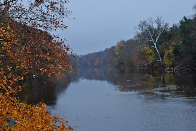
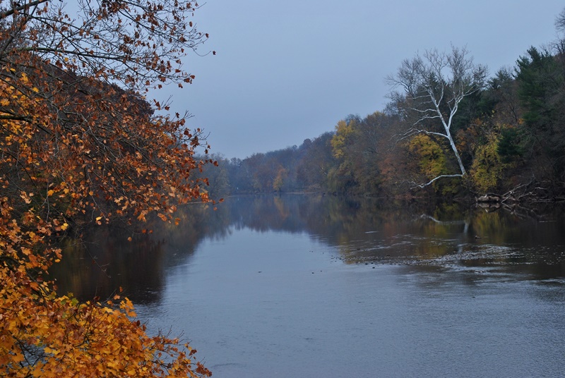
My first view of the Perkiomen Creek. While the Perkiomen Trail runs alongside the creek, it's also far enough away that the view is mostly or completely blocked by trees. In some areas, the trail is simply too far away to see the creek at all.


Once you approach Bridge Street (State Route 113), you'll get your first unobstructed view of the Perkiomen Creek (if you start in Collegeville and head north like I did) as the trail cuts under the bridge crossing over the creek. This is the view from under the bridge looking downstream.

 |
| View looking upstream from under the bridge on Bridge Street |
 |
| Looking back after passing under the bridge |
Once you cross under the bridge, you'll find one of parking lots that are alongside the Perkiomen Trail. The below address is posted at a kiosk next to the parking lot although I'm not exactly sure why. A company by the name of Rahn's Concrete is a short walk away but the parking lot itself is off Bridge Street.


 |
| Not the best of pictures but it was still colorful |
 |
| Small creek named Schoolhouse Run crossing under the Perkiomen Trail |
Once you cross over Schoolhouse Run, the next place of interest that you'll find is the Pennsylvania Live Steamers. Established in 1946, the Pennsylvania Live Steamers Inc. is a non-profit, all volunteer organization dedicated to the preservation of the nation's railroads mechanical and engineering heritage.

Unfortunately, there's a sign posted stating to respect the property by not trespassing. I was hoping for a closer look but it seems Pennsylvania Live Steamers is a members-only organization. While walking past, I saw someone working on one of the trains which was small enough to sit on top of.

 |
| Entrance to Pennsylvania Live Steamers |

Just past Pennsylvania Live Steamers is this small park although I don't recall the name of it.

Alongside the Perkiomen Trail are a number of places where you can stop to get a refreshment or bite to eat.

While mostly going in a north/south direction, there are occasional turns in the trail. Just after passing the above park and restaurant, the trail makes a turn to the east.


 |
| Perkiomen Trail turning back to the north |
This is the first of a few places where the Perkiomen Trail crosses over the creek.


This bridge is a good 40-50 above the creek which was a bit freaky to me since I'm not fond of heights. This is the view looking upstream.

 |
| Unfortunately, the power lines were there but a nice view looking downstream |
Once you cross over the bridge, the trail makes a quick loop back to the west towards the creek.


Another trail to explore! As you approach the Perkiomen Creek after crossing the bridge, the Skippack Township Trail cuts to the north, eventually leading to Evansburg State Park.


I didn't take any pictures but once you get beyond the intersecting Skippack Township Trail, you cross over Graterford Road and one of the number of different sections of Central Perkiomen Valley Park. I'm not sure why but while you're on the Perkiomen Trail, access to the park itself is fenced off. Once you get beyond the fenced off area, there's another section of the park which has a parking lot and some side trails that may be worthy of checking out in the future.


Spotted this great blue heron hanging out on a tree alongside the creek.


This view is looking downstream from the second of three bridges crossing over the Perkiomen Creek.

 |
| Looking upstream from the bridge crossing over the Perkiomen Creek |

After crossing over the bridge, you'll find another section and the headquarters of the Central Perkiomen Valley Park along with plenty of parking.

I decided to take a quick detour off the Perkiomen Trail to explore this area. I didn't walk through the whole park but I did cross over Plank Road to check out the Old Mill House.

 |
| Small gazebo with water pump just outside the Old Mill House |
Built around 1901, the Old Mill House is now used as a rental facility for events and looks relatively modern. I didn't take any pictures or go inside (not sure if it was open), but I did walk around the outside to get a view of the Perkiomen Creek.

 |
| Remnants of an old wheel from a wheelhouse on the opposite side of the creek |
This is really the only picture that I took of the Old Mill House. My guess is that at one time water used to flow through this section to power the milling operations. Previous to being called the Old Mill House, the property was being leased by Irvin Hauseman and was known as the Hauseman's Mill.
Purchased by Joseph Pawling in 1774, the building functioned as a grist mill on and off for over 100 years until a fire destroyed it in 1900. In 1910, the property was purchased by Dr. Hiran Rittenhouse Loux who rebuilt it as a summer retreat with his wife between 1910 and 1925 on the foundation of the remnants of the mill. It was at this time where it became known as the Old Mill House. In 1925, Loux sold the property where it passed through several owners until it was purchased by a politician known as Charles Smith in 1948.
On March 30, 1976, Montgomery County purchased the Old Mill House and surrounding property and the Central Perkiomen Valley Park was born.


Once I was done exploring the park, I continued on my way north towards Schwenksville. In this section of the trail, there wasn't a whole lot to see other than the remaining leaves on trees which were still colorful in some areas.


Along with a few restaurants and retail locations, the Perkiomen Trail also passes very close to private residences.


Somewhere in this area, the Perkiomen Trail crosses over West Skippack Pike (State Route 73)


Now walking into Schwenksville, you'll find Meadow Park. At 6.7 acres, it's not that large but provides locals with a pavilion, picnic tables, and a playground for kids along with a view of the Perkiomen Creek.


The trail then crosses over another stream named Mine Run and by now, I was almost at what I thought would be my objective.

This is the first of two bridges you'll be crossing once you reach East Park Avenue.
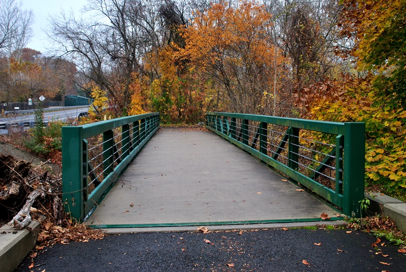
After crossing the first bridge, you'll have to cross East Park Avenue and from there you'll see the second bridge which crosses over the Perkiomen Creek for the third time (and final for this hike). As usual, my picture is crooked, the bridge isn't leaning!

 |
| View looking upstream from the bridge on East Park Avenue |
At this point, I reluctantly turned around to head back to the car. The reason I had chosen this section of the Perkiomen Trail to explore first was because I had the intention of checking out Pennypacker Mills County Park. It turns out that there's no access to the park from this section of the Perkiomen Trail unless I wanted to walk a good distance alongside roads to get there.
Had I been a little more observant during my adventure, I believe I could have accessed the park by turning west on West Skippack Pike (State Route 73), then to Haldeman Road after crossing the Perkiomen Creek. What I don't recall is if there's a sidewalk along West Skippack Pike that would have allowed me to cross the bridge without being run over, Skippack Pike can be pretty busy at times. Looking at it from Google Maps, it seems there's enough space.

On the way back to the car, I took a few shots but for the most part, was on cruise control. I stopped a few times to rest the legs but otherwise, I kept moving. It's amazing how stopping those few brief seconds to take pictures can make such a big difference and give the legs a short rest. It allows you to walk further without getting tired. On my return, the legs let me know they weren't too happy with me!
 |
| View of Mine Run looking east towards Main Street (State Route 29) |


That was it for my adventure on the Perkiomen Trail (for now). After returning to my vehicle, I dropped off the backpack and headed into the Appalachian Brewing Company to grab a bite to eat and a refreshment. The brewing company is big and very nice! If you get a chance, check it out.
I only covered a little more than 6.5 of the 20 miles of trail so I'll eventually be returning to complete the entire length but there's really no hurry to do so. I've mentioned this a number of times in my blog but I'm not keen on trails that are paved (or crushed stone), flat and straight since I eventually end up getting bored. In the Collegeville/Schwenksville areas, the trail also runs parallel to State Route 29 and with the exception of a few areas, traffic is usually within earshot.
Thankfully, walking on the Perkiomen Trail also takes you through some historic areas and there were still some nice fall colors to keep my interest peaked. I eventually plan on returning this section of the trail so I can make my way to Pennypacker Mills County Park (if it's possible).
Until next time, happy adventures and happy hiking!
No comments:
Post a Comment