Date of Hike: Thursday, October 29, 2015
Total Distance: 6.47 Miles
Avg speed: 2.4 MPH
Total Time: 2:42:2
Conditions: Mostly Sunny, 75 Degrees
Difficulty: Easy, Moderate
On October 29, I took a ride out to the Natural Lands Trust Stroud Preserve which has been on my radar for a while. I had plans to visit earlier this year but it was on a day where I had chosen two locations to explore and found out the first one had more miles of trails than I had anticipated. The Stroud Preserve is a total of 571 acres and has approximately 9 miles of trails, some of which are open for equestrian use. Dogs are also permitted as long as they're on a leash. To obtain a copy of the trail map, click here.
Approximate address is:
454 North Creek Road
West Chester, PA 19382
GPS: 39.953726, -75.647757
Google Maps will place a marker for 454 North Creek Road just to the north of the entrance to the parking lot.

I didn't think to check for a trail map while I was there but they're supposed to be available at the kiosk station when you first enter the preserve.

It's not shown on the above tracks but my starting point and the parking lot is in the northeast corner of the Stroud Preserve right about where "N Creek Rd" can be seen. I started out heading to the southwest crossing over the East Branch Brandywine Creek.

It's hard to tell in the pictures but the river was slightly flooded and brown from the rain we had the day before. This is the view looking downstream from the bridge.

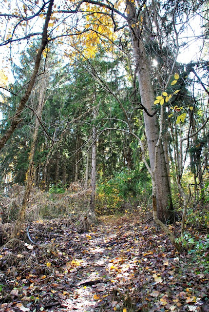
With all the wind and rain that occurred the day before, a lot of trees no longer had leaves on them. It was a great fall with the colors but it's sadly coming to an end.

Once you approach the treeline, there's a trail that makes a turn to the northeast just past these large bails of hay.

The trails at the Stroud Preserve are named by colors. For the most part, most of my journey was on the Red Trail. Once I reached this trail marker, I made a turn to the southeast, then a slight turn to the south (right) up the hill in front of the treeline.

Once you get to the top of the hill, there's an excellent view of the surrounding area.

Once you get into the woods in this area, the trail makes a sharp turn to the northeast, then back to the east. This is an unnamed connecting trail (listed as "other trails" on the trail map) leading back to the Red Trail.


The connecting trail makes its way to the Red Trail and at this point, you can continue to the east (left) or make a turn to the south (right). I lost my sense of direction in this area and continued to the east.


This section of the Red Trail leads down a hill and makes a sharp turn to the northwest. At the bottom of the hill, there's another connecting trail that makes a turn to the southeast leading to nowhere (according to the map) and the Red Trail makes a slight turn continuing northwest. This was where I figured out where I was and realized I was heading back towards the parking lot so I turned around and returned to where the Red Trail had split off to the south close to the top of the hill.

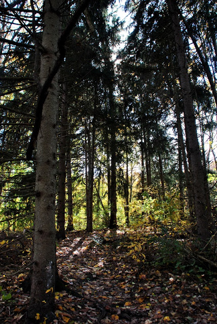
Once I returned to the split in the trail and made my turn to the south, the Red Trail leads you through a section of tall pines.
The Red Trail then takes a turn to the southwest alongside the edge of a corn field.

The Red Trail then makes another turn in a southeasterly direction and at this point, also intersects with the Green Trail which heads in a northwest direction and was where I turned off the Red Trail for the time being.

The Green Trail leads through a small grove of woods heading downhill between the two fields I was walking along. Within that grove of woods is a small stream to the west side of the trail.

The small stream seemed to be dammed at one time although there wasn't much water despite the rain we had the day before.

Once you get to the bottom of the hill, the Green Trail merges with the Yellow Trail (this is also the main dirt road that cuts through the preserve) alongside a wetland that was once a man made pond. Over time, the pond that was once there became contaminated with goose droppings and was converted to the wetlands you see today.


While the fall colors were definitely fading, there were a few places throughout the preserve that were still colorful.

Along the eastern edge of the wetlands is this wooden bench. My intention was to walk around the entire area, then return back to the Green and Red Trails.

This brought me to a stop. It doesn't look like much and it probably wasn't but there was water flowing through the area of tall grass you see below. Normally, this wouldn't have stopped me but giving there was rain the night before and it was too wide to jump across, I decided to turn around. I've walked through areas like this before and found out the hard way that the water was deeper than expected.

Back on the main road (in this section, the Yellow and Green Trails are merged), there's another unnamed connecting trail that turns in a southeast direction and back up the hill I had climbed down a few moments before this.


Once you get to this corn field, the trail takes a slight turn to the south along the treeline.

The connecting trail leads into a wooded area then intersects with the Green Trail where you can turn to the north (right) heading back toward the wetlands, or to the southeast (left) which was the direction I went.


From what it states in the below sign, at one time these woodlands were once used as farmlands and since then, thousands of trees have been planted.

Despite the fact many leaves had fallen off the trees from the wind and rain the day before, there were still some areas of fall colors remaining.


Once you reach this sign alongside Lucky Hill Road, the Greed and Red Trail meet and merge together heading to the east and was the direction I went for the time being. The Red Trail also splits off to the west.


The merged Green and Red Trails then make a turn to the north bordering private property.


Earlier during my hike, I had seen this building from the north and was hoping to check it out. Once I noticed it was private property, I turned back


Another pleasant surprise at the Stroud Preserve was how good of condition the trails were in after a day of heavy rain. There were a few wet spots throughout but nothing that was so soggy that you'd have to find a way to get around them.


I'm not sure exactly where but the Red Trail eventually makes a turn to the northwest running alongside Lucky Hill Road.


The Red and Yellow Trails merge together and continue in a northwest direction. This is also where you cross over the main dirt road that runs through the preserve and can head in a easterly direction back towards the parking lot.

Along the merged Yellow and Red Trails, there were a few areas where the trees still looked nice.


As with a number of the other preserves I've visited, hunting is permitted at the Stroud Preserve by special permit. Make sure to wear some orange if you go hiking there. Better safe than sorry!


Another curious moment. Across the street from the preserve is this sign with a trail head leading to the southwest. I would have loved to investigate what was down that trail!

The Yellow and Red Trails then take a turn to the northeast alongside the field. At this point, you're at the western edge of the preserve.

The Yellow and Red Trails split at this point with the Yellow trail continuing to the northeast (right) and the Red Trail making a turn to the northwest (left). I continued following the Red Trail.

A short distance up the Red Trail is another unmarked trail that continues to the northwest with the Red Trail making a turn to the northeast. As much as my curiosity gets to me, I stayed on the Red Trail.


Once you reach this opening, you'll see this trail marker signifying a turn on the Red Trail, now heading in an easterly direction.


A little further down the Red Trail, you'll reach one of the connecting trails that will take you south down a hill back to the Yellow Trail and was the direction I went.


Once you approach the Yellow Trail, you'll find another one of these dams to the west side of the trail.

Just alongside this small stream is a bench where I stopped to take a quick break to adjust my hiking boots and grab a quick snack. Once I was done, I headed east on the Yellow Trail for a short distance.


There's another connecting trail that leads north back up the hill to the Red Trail and the was direction I went. This is a four way intersection where you can continue east on the Yellow Trail, head south on the connecting trail which would bring you to the main dirt road, or to the north.

Once you get to the top of the hill and return to the Red Trail, it takes a turn to the east

I'm not fond of taking pictures of power lines but I liked how the trail was running up the hill alongside them. This view is looking to the north.


Once you see the pond in the above picture, the Red Trail takes a turn to the southeast, then to the southwest towards the Yellow Trail once you get to the bottom of the hill. Once you reach the Yellow Trail, it intersects and merges with the Red Trail heading to the southeast and was the direction I went. You can also continue on the Yellow Trail heading southwest.

The merged Yellow and Red Trails will take you alongside the wetlands from the opposite side (close to where I turned around earlier in the day). It takes a slight turn to the northeast and when you reach the dirt road you see in the background, it turns to the southeast over the bridge and back to the main dirt road the runs through the preserve. If you look to the north, you'll see a private residence and large barn.


Once you cross over the East Branch Brandywine Creek, you can turn either northwest or southeast on the Purple Trail. I made a turn to the northwest.


Along the Purple Trail, you can see the East Branch Brandywine Creek in some areas but for the most part, you're a good distance away and the view is shrouded by trees.


The Purple Trail makes a turn to the east and gradually turns again to the north alongside a creek named Taylor Run. Again, there's not much of a view of the creek except in a few small spots.

The trail then loops back to the south heading towards the parking lot.

That was it for my adventure at the Stroud Preserve. In all, there's a nice mix of woods and fields as well as varying terrain that kept me interested. While there are some woodlands, I was glad to have waited until it was cooler outside to explore as there's not a lot of cover from the sun. I learned a new appreciation for hiking in open fields this summer but on the flip side of the coin, hiking under a blazing sun can get pretty toasty. Eventually, I'd like to return here to check out some of the trails I missed but there won't be any rush.
Another item to note is that alongside the Stroud Preserve are two (or three depending on how you look at it) other preserves, the Susan Groome (two different pieces of land) and the Harney and Baker Preserves. There's very little information about these preserves online so I'm not sure if they are open to the public. If they are, it'll make a good excuse to return and continue explorations!
Until next time, happy exploring and happy hiking!
Please give my Facebook page a like!
On October 29, I took a ride out to the Natural Lands Trust Stroud Preserve which has been on my radar for a while. I had plans to visit earlier this year but it was on a day where I had chosen two locations to explore and found out the first one had more miles of trails than I had anticipated. The Stroud Preserve is a total of 571 acres and has approximately 9 miles of trails, some of which are open for equestrian use. Dogs are also permitted as long as they're on a leash. To obtain a copy of the trail map, click here.
Approximate address is:
454 North Creek Road
West Chester, PA 19382
GPS: 39.953726, -75.647757
Google Maps will place a marker for 454 North Creek Road just to the north of the entrance to the parking lot.

I didn't think to check for a trail map while I was there but they're supposed to be available at the kiosk station when you first enter the preserve.

It's not shown on the above tracks but my starting point and the parking lot is in the northeast corner of the Stroud Preserve right about where "N Creek Rd" can be seen. I started out heading to the southwest crossing over the East Branch Brandywine Creek.

It's hard to tell in the pictures but the river was slightly flooded and brown from the rain we had the day before. This is the view looking downstream from the bridge.

 |
| Looking upstream on the East Branch Brandywine Creek |
With all the wind and rain that occurred the day before, a lot of trees no longer had leaves on them. It was a great fall with the colors but it's sadly coming to an end.

Once you approach the treeline, there's a trail that makes a turn to the northeast just past these large bails of hay.

The trails at the Stroud Preserve are named by colors. For the most part, most of my journey was on the Red Trail. Once I reached this trail marker, I made a turn to the southeast, then a slight turn to the south (right) up the hill in front of the treeline.

Once you get to the top of the hill, there's an excellent view of the surrounding area.

Once you get into the woods in this area, the trail makes a sharp turn to the northeast, then back to the east. This is an unnamed connecting trail (listed as "other trails" on the trail map) leading back to the Red Trail.


The connecting trail makes its way to the Red Trail and at this point, you can continue to the east (left) or make a turn to the south (right). I lost my sense of direction in this area and continued to the east.


This section of the Red Trail leads down a hill and makes a sharp turn to the northwest. At the bottom of the hill, there's another connecting trail that makes a turn to the southeast leading to nowhere (according to the map) and the Red Trail makes a slight turn continuing northwest. This was where I figured out where I was and realized I was heading back towards the parking lot so I turned around and returned to where the Red Trail had split off to the south close to the top of the hill.

Once I returned to the split in the trail and made my turn to the south, the Red Trail leads you through a section of tall pines.


The Red Trail then takes a turn to the southwest alongside the edge of a corn field.

 |
| Red Trail making a turn to the southeast |
The Red Trail then makes another turn in a southeasterly direction and at this point, also intersects with the Green Trail which heads in a northwest direction and was where I turned off the Red Trail for the time being.

The Green Trail leads through a small grove of woods heading downhill between the two fields I was walking along. Within that grove of woods is a small stream to the west side of the trail.

The small stream seemed to be dammed at one time although there wasn't much water despite the rain we had the day before.

Once you get to the bottom of the hill, the Green Trail merges with the Yellow Trail (this is also the main dirt road that cuts through the preserve) alongside a wetland that was once a man made pond. Over time, the pond that was once there became contaminated with goose droppings and was converted to the wetlands you see today.


While the fall colors were definitely fading, there were a few places throughout the preserve that were still colorful.

Along the eastern edge of the wetlands is this wooden bench. My intention was to walk around the entire area, then return back to the Green and Red Trails.

This brought me to a stop. It doesn't look like much and it probably wasn't but there was water flowing through the area of tall grass you see below. Normally, this wouldn't have stopped me but giving there was rain the night before and it was too wide to jump across, I decided to turn around. I've walked through areas like this before and found out the hard way that the water was deeper than expected.

 |
| There are some nice rolling hills at the Stroud Preserve! |
Back on the main road (in this section, the Yellow and Green Trails are merged), there's another unnamed connecting trail that turns in a southeast direction and back up the hill I had climbed down a few moments before this.


Once you get to this corn field, the trail takes a slight turn to the south along the treeline.

The connecting trail leads into a wooded area then intersects with the Green Trail where you can turn to the north (right) heading back toward the wetlands, or to the southeast (left) which was the direction I went.


From what it states in the below sign, at one time these woodlands were once used as farmlands and since then, thousands of trees have been planted.

Despite the fact many leaves had fallen off the trees from the wind and rain the day before, there were still some areas of fall colors remaining.


 |
| The road to the right side is Lucky Hill Road |
Once you reach this sign alongside Lucky Hill Road, the Greed and Red Trail meet and merge together heading to the east and was the direction I went for the time being. The Red Trail also splits off to the west.


The merged Green and Red Trails then make a turn to the north bordering private property.


Earlier during my hike, I had seen this building from the north and was hoping to check it out. Once I noticed it was private property, I turned back

 |
| Back to Lucky Hill Road and heading west on the Red Trail |

Another pleasant surprise at the Stroud Preserve was how good of condition the trails were in after a day of heavy rain. There were a few wet spots throughout but nothing that was so soggy that you'd have to find a way to get around them.


 |
| It was warm enough out that I had a few sightings of moths/butterflies |
 |
| View looking across Lucky Hill Road |
I'm not sure exactly where but the Red Trail eventually makes a turn to the northwest running alongside Lucky Hill Road.


The Red and Yellow Trails merge together and continue in a northwest direction. This is also where you cross over the main dirt road that runs through the preserve and can head in a easterly direction back towards the parking lot.

Along the merged Yellow and Red Trails, there were a few areas where the trees still looked nice.


As with a number of the other preserves I've visited, hunting is permitted at the Stroud Preserve by special permit. Make sure to wear some orange if you go hiking there. Better safe than sorry!


 |
| Still hiking alongside Lucky Hill road |
Another curious moment. Across the street from the preserve is this sign with a trail head leading to the southwest. I would have loved to investigate what was down that trail!

The Yellow and Red Trails then take a turn to the northeast alongside the field. At this point, you're at the western edge of the preserve.

The Yellow and Red Trails split at this point with the Yellow trail continuing to the northeast (right) and the Red Trail making a turn to the northwest (left). I continued following the Red Trail.

A short distance up the Red Trail is another unmarked trail that continues to the northwest with the Red Trail making a turn to the northeast. As much as my curiosity gets to me, I stayed on the Red Trail.


 |
| Some sort of fungus on this leaf |
Once you reach this opening, you'll see this trail marker signifying a turn on the Red Trail, now heading in an easterly direction.


A little further down the Red Trail, you'll reach one of the connecting trails that will take you south down a hill back to the Yellow Trail and was the direction I went.


Once you approach the Yellow Trail, you'll find another one of these dams to the west side of the trail.

Just alongside this small stream is a bench where I stopped to take a quick break to adjust my hiking boots and grab a quick snack. Once I was done, I headed east on the Yellow Trail for a short distance.


There's another connecting trail that leads north back up the hill to the Red Trail and the was direction I went. This is a four way intersection where you can continue east on the Yellow Trail, head south on the connecting trail which would bring you to the main dirt road, or to the north.

 |
| Heading back up the hill to the Red Trail |
Once you get to the top of the hill and return to the Red Trail, it takes a turn to the east

I'm not fond of taking pictures of power lines but I liked how the trail was running up the hill alongside them. This view is looking to the north.

 |
| Red Trail still heading east through another field |
 |
| View from the Red Trail looking to the south into the Stroud Preserve |


 |
| Looking to the northeast from the Red Trail to a pond on private property |
Once you see the pond in the above picture, the Red Trail takes a turn to the southeast, then to the southwest towards the Yellow Trail once you get to the bottom of the hill. Once you reach the Yellow Trail, it intersects and merges with the Red Trail heading to the southeast and was the direction I went. You can also continue on the Yellow Trail heading southwest.

 |
| Now heading back towards the wetlands I saw earlier in the day |
The merged Yellow and Red Trails will take you alongside the wetlands from the opposite side (close to where I turned around earlier in the day). It takes a slight turn to the northeast and when you reach the dirt road you see in the background, it turns to the southeast over the bridge and back to the main dirt road the runs through the preserve. If you look to the north, you'll see a private residence and large barn.

 |
| Back on the main preserve dirt road heading towards the parking lot |
 |
| Almost back to the parking lot, but I wasn't done hiking yet! |

Once you cross over the East Branch Brandywine Creek, you can turn either northwest or southeast on the Purple Trail. I made a turn to the northwest.


Along the Purple Trail, you can see the East Branch Brandywine Creek in some areas but for the most part, you're a good distance away and the view is shrouded by trees.


The Purple Trail makes a turn to the east and gradually turns again to the north alongside a creek named Taylor Run. Again, there's not much of a view of the creek except in a few small spots.

The trail then loops back to the south heading towards the parking lot.

 |
| Almost back to the parking lot, the entrance is to the left of this picture |
 |
| This tree was right next to the parking lot |
That was it for my adventure at the Stroud Preserve. In all, there's a nice mix of woods and fields as well as varying terrain that kept me interested. While there are some woodlands, I was glad to have waited until it was cooler outside to explore as there's not a lot of cover from the sun. I learned a new appreciation for hiking in open fields this summer but on the flip side of the coin, hiking under a blazing sun can get pretty toasty. Eventually, I'd like to return here to check out some of the trails I missed but there won't be any rush.
Another item to note is that alongside the Stroud Preserve are two (or three depending on how you look at it) other preserves, the Susan Groome (two different pieces of land) and the Harney and Baker Preserves. There's very little information about these preserves online so I'm not sure if they are open to the public. If they are, it'll make a good excuse to return and continue explorations!
Until next time, happy exploring and happy hiking!
Please give my Facebook page a like!
No comments:
Post a Comment