Date of Hike: Sunday, November 1, 2015
Total Distance: 8.39 Miles
Avg speed: 2.7 MPH
Total Time: 3:7:49
Conditions: Mostly Sunny, 66 Degrees
Difficulty: Easy, Moderate
This past Sunday, I took another hike along the Horse-Shoe Trail, this time starting at the Bright Side Farm and hiking to the Montgomery School which is located next to Kimberton Road (State Route 113). The last time I was at the Bright Side Farm was when I hiked from the Great Valley Nature Center to the farm back in August.
For a copy of the trail map, you'll need to purchase a guidebook (which includes the maps, a total of 10) for $15 from the Horse-Shoe Trail website.
The address of the Bright Side Farm is:
3018 Yellow Springs Road
Malvern, PA 19355
GPS: 40.075305, -75.578455
Once you pull into the driveway to the farm, you can park in the grass anywhere alongside. Look for the signs on the telephone poles, you won't be able to miss them.


The Horse-Shoe Trail is a short walk from the Bright Side Farm. Once you walk to the entrance of the farm, turn to the southeast on Yellow Springs Road, then to the southwest on Valley Hill Road.

Follow alongside Valley Hill Road for a distance where it'll take another small turn to the south.


The Horse-Shoe Trail then takes a turn to the southwest along the edge of private property. If you look on the right side of this picture, you can see a portion of a shed that's in the back yard of this home.


The trail makes a turn to the west, then crosses over this small creek.

After crossing over the creek, the trail then makes another turn to the northwest.

When you reach this opening in the trees, the trail then takes another turn to the southwest. This view is looking to the northeast.


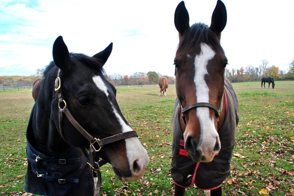
As you continue hiking to the southwest, you end up alongside the Reinbow's End Farm which provides services (lessons, boarding, etc.) for horses.


When you reach the southeastern end of the farm, the Horse-Shoe Trail then takes a turn to the northwest.


Once you make your turn to the northwest, you'll be hiking parallel with Green Lane Road for a short distance, then the trail and the road merge once you get past the farm.


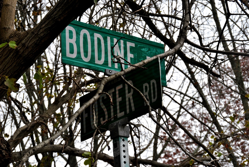
Once you reach the corner of Green Lane and Foster Roads, the Horse-Shoe Trail takes a turn to the southwest.

Similar to Green lane Road, the Horse-Shoe Trail runs parallel with Foster Road for a short distance.
Once you get to the area of Rapps Run Drive, the trail merges with Foster Road.


I should have taken a picture of it but once I reached the corner of Foster and Bodine Roads, the Horse-Shoe Trail takes a turn to the northwest. On the corner of these two roads, there's a trail marker signifying a turn that I misread and instead of going northwest, I turned to the southeast. Thankfully the trail is well marked and I realized my mistake before going very far.


Bodine Road veers to the northeast and from here, the trail continues along to the northwest on what was supposed to be a wooded area and is now a relatively newly paved road. I have no idea what the name of this road is.

The unnamed road then also takes a turn in a northeast direction and the Horse-Shoe Trail continues to the northwest through a wooded area.


The Horse-Shoe Trail changes direction a few times in this area but is mainly headed in a northwest direction.


Once you get beyond the above turn in the trail, you'll be cutting through a small field and through a gate in the fence (middle right side where the two fences meet).

Walk through the gate (make sure you close and latch it after walking through) and you'll be at the intersection of Lower Pine Creek Road and the paved Horse-Shoe Trail.

Right on the corner, there's a small dam and waterfall along Pine Creek. What you don't see is the electric fence that surrounds the entire property where this waterfall is. I guess whoever owns this property wants to make sure no one gets in!


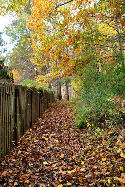
Still heading in a northwest direction, I took some pictures of what's left of the fall colors along the paved Horse-Shoe Trail.


Almost at my destination, this is the corner of the paved Horse-Shoe Trail and Kimberton Roads (State Route 113) and from here, a turn to the north. Be advised, Kimberton Road is a busy street.

The paved Horse-Shoe Trail continues to the northwest once it crosses over Kimberton Road.

Once you reach the corner of the Horse-Shoe Trail and Kimberton Roads, you'll see a ball field which is part of the Montgomery School. Founded in 1915 by Reverend Gibson Bell, it was originally a preparatory school for boys from the first through twelfth grades. If you're interested in learning about the history of the school, click here.

I hiked a little further up the paved Horse-Shoe Trail and once I reached Pickering Creek, I turned back to head to the car. Before starting my journey back to the car, I took a quick break at the ball field which looks like it hasn't been used in some time.


On the way back to Bright Side Farm, I took what pictures I could, most of which were of any fall colors remaining on the trees.


Passing the Reinbow's End Farm again, this time some of the horses walked up to greet me.


These last two pictures were taken in the wooded area between Green Lane and Valley Hill Roads.


That was it for my adventure on this section of the Horse-Shoe Trail. It was a decent hike with a few hills that got the blood pumping but nothing too strenuous. In total, there are 10 different maps for the Horse-Shoe Trail and with the completion of this stretch of the trail, I've completed map #1. Only 9 more to go! I'm not fond of walking alongside roads but am determined to eventually complete the entire 148 miles of the trail so for this, I'm sucking it up and going with the flow.
Until next time, happy adventures and happy hiking!
Please give my Facebook page a like!
This past Sunday, I took another hike along the Horse-Shoe Trail, this time starting at the Bright Side Farm and hiking to the Montgomery School which is located next to Kimberton Road (State Route 113). The last time I was at the Bright Side Farm was when I hiked from the Great Valley Nature Center to the farm back in August.
For a copy of the trail map, you'll need to purchase a guidebook (which includes the maps, a total of 10) for $15 from the Horse-Shoe Trail website.
The address of the Bright Side Farm is:
3018 Yellow Springs Road
Malvern, PA 19355
GPS: 40.075305, -75.578455
Once you pull into the driveway to the farm, you can park in the grass anywhere alongside. Look for the signs on the telephone poles, you won't be able to miss them.


The Horse-Shoe Trail is a short walk from the Bright Side Farm. Once you walk to the entrance of the farm, turn to the southeast on Yellow Springs Road, then to the southwest on Valley Hill Road.

Follow alongside Valley Hill Road for a distance where it'll take another small turn to the south.


The Horse-Shoe Trail then takes a turn to the southwest along the edge of private property. If you look on the right side of this picture, you can see a portion of a shed that's in the back yard of this home.


The trail makes a turn to the west, then crosses over this small creek.

After crossing over the creek, the trail then makes another turn to the northwest.

When you reach this opening in the trees, the trail then takes another turn to the southwest. This view is looking to the northeast.


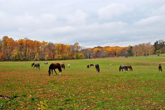
As you continue hiking to the southwest, you end up alongside the Reinbow's End Farm which provides services (lessons, boarding, etc.) for horses.


 |
| There are a lot of horses being boarded at this farm |


When you reach the southeastern end of the farm, the Horse-Shoe Trail then takes a turn to the northwest.

 |
| Lots of horses and some remaining fall colors in the background |

Once you make your turn to the northwest, you'll be hiking parallel with Green Lane Road for a short distance, then the trail and the road merge once you get past the farm.


 |
| Fall colors along Green Hill Road |
 |
| Not sure what these ruins are but they were right alongside the road |

Once you reach the corner of Green Lane and Foster Roads, the Horse-Shoe Trail takes a turn to the southwest.

Similar to Green lane Road, the Horse-Shoe Trail runs parallel with Foster Road for a short distance.

Once you get to the area of Rapps Run Drive, the trail merges with Foster Road.


 |
| Old spring house? Alongside Foster Road |


I should have taken a picture of it but once I reached the corner of Foster and Bodine Roads, the Horse-Shoe Trail takes a turn to the northwest. On the corner of these two roads, there's a trail marker signifying a turn that I misread and instead of going northwest, I turned to the southeast. Thankfully the trail is well marked and I realized my mistake before going very far.

 |
| Passing Seven Oaks Road heading northwest on Bodine Road |
Bodine Road veers to the northeast and from here, the trail continues along to the northwest on what was supposed to be a wooded area and is now a relatively newly paved road. I have no idea what the name of this road is.

The unnamed road then also takes a turn in a northeast direction and the Horse-Shoe Trail continues to the northwest through a wooded area.


 |
| Turkey vultures were circling overhead |


The Horse-Shoe Trail changes direction a few times in this area but is mainly headed in a northwest direction.


 |
| Approaching Lower Pine Creek Road |
Once you get beyond the above turn in the trail, you'll be cutting through a small field and through a gate in the fence (middle right side where the two fences meet).

Walk through the gate (make sure you close and latch it after walking through) and you'll be at the intersection of Lower Pine Creek Road and the paved Horse-Shoe Trail.

Right on the corner, there's a small dam and waterfall along Pine Creek. What you don't see is the electric fence that surrounds the entire property where this waterfall is. I guess whoever owns this property wants to make sure no one gets in!


Still heading in a northwest direction, I took some pictures of what's left of the fall colors along the paved Horse-Shoe Trail.


Almost at my destination, this is the corner of the paved Horse-Shoe Trail and Kimberton Roads (State Route 113) and from here, a turn to the north. Be advised, Kimberton Road is a busy street.

 |
| Crossed over Kimberton Road and heading north |
The paved Horse-Shoe Trail continues to the northwest once it crosses over Kimberton Road.

Once you reach the corner of the Horse-Shoe Trail and Kimberton Roads, you'll see a ball field which is part of the Montgomery School. Founded in 1915 by Reverend Gibson Bell, it was originally a preparatory school for boys from the first through twelfth grades. If you're interested in learning about the history of the school, click here.

I hiked a little further up the paved Horse-Shoe Trail and once I reached Pickering Creek, I turned back to head to the car. Before starting my journey back to the car, I took a quick break at the ball field which looks like it hasn't been used in some time.

 |
| Looking south on Kimberton Road |

On the way back to Bright Side Farm, I took what pictures I could, most of which were of any fall colors remaining on the trees.


 |
| I believe this is Bodine Road |
 |
| Somewhere between Bodine and Foster Roads |

 |
| Now headed southeast on Green lane Road |
Passing the Reinbow's End Farm again, this time some of the horses walked up to greet me.


These last two pictures were taken in the wooded area between Green Lane and Valley Hill Roads.


That was it for my adventure on this section of the Horse-Shoe Trail. It was a decent hike with a few hills that got the blood pumping but nothing too strenuous. In total, there are 10 different maps for the Horse-Shoe Trail and with the completion of this stretch of the trail, I've completed map #1. Only 9 more to go! I'm not fond of walking alongside roads but am determined to eventually complete the entire 148 miles of the trail so for this, I'm sucking it up and going with the flow.
Until next time, happy adventures and happy hiking!
Please give my Facebook page a like!
You walked right past my house! The one on Green Lane Road with the "chickens at play " sign on the fence! Wish I had known, I would have grabbed the goats and hiked with you!
ReplyDeleteAwww, sorry I missed you!
Delete