Date of Hike: Saturday, February 27, 2016
Total Distance: 8.90 Miles
Avg speed: 2.1 MPH
Total Time: 4:10:06
Conditions: Sunny, 41 Degrees
Difficulty: Easy, Moderate, some Difficult
At last, a long overdue post! There's a reason for this which I'll explain in a bit. Almost three months ago, I took a ride out to Wolf's Hollow County Park to explore the trails which turned out to be a pretty fun adventure. In all, the park is a total of 569 acres with almost 10 miles of trails.
Address:
1399 Schoff Road
Atglen, PA 19310
GPS: 39.910993, -75.984509
For a copy of the trail map, click here. I don't recall if there were trail maps provided so you may want to bring one with you. Once you turn on to Wolf's Hollow Road (the park entrance), you'll see the parking lot and trail head on the left side after a few hundred yards.

Wolf's Hollow County park was officially opened on December 6, 2010 and is Chester County's sixth regional park site. It was named after the 1789 land patent granted to James and David Sterrett. The first known record of ownership was in 1733 when a Philadelphia merchant by the name of Samuel Mickle requested a warrant of 1,000 acres which included the park.
Wolf's Hollow exchanged hands several times during its history. In 1743, Mickle issued a mortgage to a man by the name of John Dunn for a parcel in the center of the park. After the Revolutionary War, the first president of Delaware (John McKinley) briefly owned the land prior to the Sterrets.
In the 19th century, the area may have also been used for industrial enterprise (forges, mills, etc.)

When you start your adventure, you'll have a number of choices for which direction you'd like to go.

As is my usual routine, my intention is to maximize distance and not overlap so I chose to start out in a westerly direction on the Upper Wolf's Hollow Trail.

When you first start out, you'll be walking in an open field but this doesn't last too long if you decide to head west.
It wasn't too cold at 41 degrees but it was still a bit on the chilly side to start. Climbing a moderately sized hill was a good way to warm up for the adventure and it got the blood pumping a bit.

Still heading primarily in a westerly direction, the trail changes directions a few times from northwest to southwest and back again as you're hiking the Upper Wolf's Hollow Trail. At this point, the turn is to the northwest and into the woods.

In this section of the park, the trails are in excellent condition although some of that would change further into the adventure.


As you're hiking the Upper Wolf's Hollow Trail, you'll be on a ridge where if you look to the north, you'll be looking down a relatively steep hill. As you're walking the trail, it turns from the northwest to southwest along this ridge.

Another turn in the trail back to the northwest and at this point, you're getting close to heading down the hill the trail runs alongside.

Another turn in the trail and from here, you begin to head down the hill. The trail is steep and a bit on the rocky side as you'll see but being here in Pennsylvania, this should come as no surprise!


This was the view looking downhill from the top. As you can see, the trails in this area are pretty well marked.

Once you get to the bottom of the hill, you'll end up alongside an unnamed creek. With all the recent wet weather at the time (rain and snow, plus melting snow from Jonas), this little creek was a bit cloudy and flooded. At this point, the trail also takes a turn to the northeast running parallel with the trail on top of the hill I had just explored.


Opposite of the creek and looking up the hill to the south, there are quite a few rocks alongside the trail. I thought the moss on the rocks looked nice but unfortunately, pictures don't always convey what the eyes are seeing.


The Upper Wolf's Hollow Trail eventually makes its way back to the open field where I had first started my adventure. Directly to my right and up the small hill is the parking lot. At this point, I crossed over the bridge in the below picture and turned to the west to explore the opposite side of the unnamed creek. Once you cross over the bridge and creek, you'll be on the Octororo Ridge Trail.
Remnants of Schoff Dam. Unfortunately, other than the name, there's not much more information to be found about its history or what it may have been used for other than to create a pond.

Now on the Octororo Ridge Trail heading in a westerly direction.

At this point, the condition of the trails began to deteriorate and were a bit on the muddy side in this area.


Once you cross over the small bridge in the above picture, the Octororo Ridge Trail takes a sharp turn to the northeast and intersects with the Shortcut Trail which continues alongside the unnamed creek.

Like many of the other parks in the area, hunting is permitted within the grounds of Wolf's Hollow County Park. Please make sure you're aware of this should you decide to explore during hunting season and wear safety gear so you won't be mistaken for someone's dinner!

Like the Octororo Ridge Trail, the Shortcut Trail also takes a turn to the northeast (more north than east). It's not shown on the trail map of the park but at this point, an unnamed trail continues alongside the creek for a distance which I decided to explore.


The unnamed trail runs alongside the creek for maybe a few hundred more yards and leads almost seemingly right into the creek. Although I probably could have kept going, it was at this point where I decided to turn back. A little further downstream from this point is the Octororo Creek.

Returning to the Shortcut Trail, it was time to head up the hill to see the rest of the park.

Once you get to the top of the hill, you'll be returning to the Octororo Ridge Trail (hence the name Shortcut Trail) and can either head to the northeast or southwest. Heading northeast would have brought be back to where I had already been so I made the turn to the southwest.
A short distance down the Octororo Ridge Trail is a spot where you can have a picnic or take a brief rest. According to the trail map, this is one of the five scenic overlooks on the trail but to be honest, there isn't much to look at. Had there been leaves on the trees, there would have been even less to see. I took a quick look at the view and kept moving. At this point, the trail takes a turn to the north.


I thought this was pretty cool. I've seen ice like this countless times over my lifetime but this was the first time I've actually been able to photograph it.


Still heading north, the Octororo Ridge Trail eventually intersects with a connecting trail that would bring you east to the Fenceline Trail but for the time being, I continued heading north.


When you reach the northernmost part of the Octororo Ridge Trail, it loops around to the southeast. It's at this point where you'll find another intersecting trail continuing to the north and heading down the hill that I mistakenly thought was a different trail.

This is the view looking back to the Octororo Ridge Trail from the unnamed trail. You can see a sign post on the right side of the trail which I thought was just missing a trail name and decided to continue.


Whoops! A few hundred yards down this unnamed trail was this fence and was where I realized I had to turn back. Thankfully the hill I descended to get to this point wasn't too steep since I now had to climb back up to get back to the Octororo Ridge Trail. Although it wasn't much to see from this vantage point, the Octororo Creek is in the background.


Gradually, the Octororo Ridge Trail turns to the east, then slightly to the northeast with another connector that would bring you to the Fenceline Trail. Again, I stayed on the Octororo Ridge Trail for the time being.


I'm not sure if I missed the sign or if it wasn't there but once you hike a little further east on the Octororo Ridge Trail, it comes to an end at that point, you can either turn south on a connector to get to the Fenceline Trail, or northeast on the Waterfalls Trail. I turned to the northeast to explore the Waterfalls Trail. After a short distance, the trail takes a turn back to the northwest.
It was at this point where the hike became pretty interesting for a while...

The Waterfalls Trail was in pretty bad shape due to all of the rain and snow causing quite a bit of erosion. This section was probably the most damaged and ran for quite a distance, although not as bad as what you see in the below picture.

Some of it was also a bit on the deceptive side. What looked like sturdy ground turned out to be a few inched of mud. After my first step in it and discovering it was deeper than I wanted to be walking in, I was a bit more careful about where I was walking.


Getting close to the bottom of the hill, the erosion wasn't as bad and the flowing water had receded back to being a small stream from what I would guess was pretty badly flooded at one point to cause that much damage. The small stream created quite a nice view and small waterfall.


Finally making my way to the bottom of the hill, the Waterfalls Trail turns back to the east alongside but not close to the Octororo Creek, at least not at this point.

It was at this point where I realized I had made another mistake. Not with the hiking part but with my camera. Before heading out, I forgot to check to make sure my batteries were charged. It turned out that ALL THREE of them for my one camera were dead! Thankfully, I always carry two cameras with me and was able to continue taking pictures for the duration of my adventure. It would have stunk if I made it this far and had to cut this blog post short due to me forgetting to check my batteries. Safe to say, they all got recharged after returning home!

My other camera (Olympus SZ-12) is much smaller and can fit in my pocket which is where it normally stays while I'm hiking due to some of the glitches I found out about it. It takes fantastic macro pictures but there are times where it won't focus on the subject which is very frustrating, and taking pictures in bright light ended up being way overexposed. I finally figured out how to turn down the exposure to allow less light which certainly helped but it took some experimenting to get it right.
The focusing issue isn't difficult when taking scenic pictures but when you're trying to get a macro shot, it tends to focus on whatever is in the background resulting in blurry pictures. I still haven't figured out if there's a way to fix this problem! Grrrrr!!


Once you get to the bottom of the hill, the Waterfalls Trail turns to the east and levels out. While this section was a bit muddy, it wasn't nearly as bad as the trek down the hill and had little damage.

This next series of pictures were the remnants of a building and stone wall. Like the Schoff Dam and other than a mention of possible settlements and forges along the creek on Chester County's website, information about was once there is scarce.


Once I was done checking out the ruins, I continued on my way to the east on the Waterfalls Trail. Take note there's a shooting range (Atglen Sportsmen's Club) close by which can be quite loud in this section of the park.
The Waterfalls Trail then takes turn to the southwest and heads up a hill. There was some water damage to this section of the trail as well but not nearly as bad as what was seen when first heading down the trail.


As you get towards the top of the hill, there's are a few relatively nice overlooks. It would probably be a bit nicer had there been some leaves on the trees!


I'm not sure why I didn't explore it but at the Gap Overlook, there's another trail (Loop Trail C) that leads down the hill you see below and around the field and circles back to this overlook.

Now at the top of the hill, the Waterfalls Trail comes to an end and meets up with the Fenceline Trail heading west.

The Fenceline Trail runs along the edge of a field and what I believe to be a farm.


Once you get beyond the fence, the Fenceline Trail continues along the edge of the fields, still heading to the west.

The Fenceline Trail briefly takes you through the woods and turns to the south before making another turn to the east and back to the open field.

Once I reached the farmhouse, I turned south on a connecting trail that would bring me back to the Octororo Ridge Trail on a section I hadn't yet explored.

Now at the intersecting Octororo Ridge Trail (the yellow box below), I continued heading south


The Octororo Ridge Trail changes directions a few times, eventually making its way to the north and alongside this small pond (at this point, the trail had actually made another turn back to the south). Perhaps during the warmer months, this would be a pretty nice spot to hang out but there was a cold wind blowing through the open field so I didn't stay long.


This sign needs a bit of an explanation. As I continued to the south on the Octororo Ridge Trail, it was face-up on the ground at an intersecting connector trail and alongside a creek...nowhere near any available parking! I hadn't thought about it until I looked at my pictures but if I had taken another picture showing where this sign was, I'm pretty sure the humor I found in its location would be better understood.

The connector trail heads east towards Wolf's Hollow Drive and eventually brings you to a small parking lot.

Once I reached the small parking lot, I took a turn to the north on Wolf's Hollow Road. Almost directly across the street from the parking lot is this home known as the Orchard House (named due to the apple orchards that were once growing there) which is believed to have been the home of a man by the name of John Dunn in the mid 1700's. The home was rebuilt in 1935 for the tenant farmer of the Schoff Dairy Farm (no name was provided).


After taking a few pictures of the Orchard House, I continued north on Wolf's Hollow Road

Thinking the trail was on the inside of the above fence, I cut through this section. I believe there are a number of picnic tables in this area but I don't recall. What I do remember though, was that the ground in this area was pretty soggy.

Once you get to the edge of the fence, you'll find Loop Trail B heading east and away from Wolf's Hollow Road.


Once you reach the end of the fence you see in the above picture, Loop Trail B turns to the south. While it changes directions a few times from southeast to southwest and back again, the primary direction is to the south.


Loop Trail B cuts through an opening in the fence and at this point, makes one final turn to the southwest. Somewhere in this area is another picnic table and where I finally made a quick stop to grab a snack and change into a pair of dry socks. I didn't stay long though, it was cold on top of this hill!

Now getting close to the parking lot, this is the view of Schoff Dam from the opposite side. What I missed in this area are another set of ruins from an old boathouse that used to be there when the dam wasn't breached.


Once beyond the Schoff Dam, I could see the parking lot but my adventure wasn't over just yet. There was one more trail to explore, known as Loop Trail A.

Loop Trail A skirts around the edge of another open field along Schoff Road and past the main entrance to Wolf's Hollow County Park. It then follows alongside Wolf's Hollow Road until you return to the parking lot area which is across the street from the trail.


That was it for my adventure at Wolf's Hollow County Park. In all, it was a good hike and one I'd definitely like to return to. The terrain was various enough to provide a good challenge and the trails were pretty well marked throughout the adventure. The condition of the trails in some areas were pretty bad but in my opinion, no fault of those who work or volunteer their services at the park. There had been a lot of snow and rain (more rain than snow) leading up to my adventure leaving the ground already saturated, creating prime conditions for the amount of erosion I saw during this hike.
Although there are ways to maintain trails in attempt to make sure they don't get destroyed, there's only so much one can do when Mother Nature decides to take her course. There's no way of stopping it from happening if the conditions are right. It's still worth the drive to get out there, just make sure you're aware of the areas where the erosion has occurred and avoid them if you don't want to deal with it.
The reason for not hiking or posting over the last few months was due to re-aggravating a pinched nerve in my neck the day after I went on this adventure. If you've ever pinched a nerve in your neck, you'll also know that the pain can be excruciating and that sitting at a desk for a number of hours was simply out of the question due to how uncomfortable it was. I was having troubles sleeping, couldn't move around well, and finally after a few months of rehab with a massage therapist and chiropractor, things are beginning to return to normal. The pain is gone but I still get an occasional tingling down my right arm. Along with the pinched nerve, taking care of the home now that the weather has gotten warmer has taken up a good amount of time as well. I'll eventually be back on the trail, hopefully soon!
Until next time, happy exploring and happy hiking!
At last, a long overdue post! There's a reason for this which I'll explain in a bit. Almost three months ago, I took a ride out to Wolf's Hollow County Park to explore the trails which turned out to be a pretty fun adventure. In all, the park is a total of 569 acres with almost 10 miles of trails.
Address:
1399 Schoff Road
Atglen, PA 19310
GPS: 39.910993, -75.984509
For a copy of the trail map, click here. I don't recall if there were trail maps provided so you may want to bring one with you. Once you turn on to Wolf's Hollow Road (the park entrance), you'll see the parking lot and trail head on the left side after a few hundred yards.

Wolf's Hollow County park was officially opened on December 6, 2010 and is Chester County's sixth regional park site. It was named after the 1789 land patent granted to James and David Sterrett. The first known record of ownership was in 1733 when a Philadelphia merchant by the name of Samuel Mickle requested a warrant of 1,000 acres which included the park.
Wolf's Hollow exchanged hands several times during its history. In 1743, Mickle issued a mortgage to a man by the name of John Dunn for a parcel in the center of the park. After the Revolutionary War, the first president of Delaware (John McKinley) briefly owned the land prior to the Sterrets.
In the 19th century, the area may have also been used for industrial enterprise (forges, mills, etc.)

When you start your adventure, you'll have a number of choices for which direction you'd like to go.
As is my usual routine, my intention is to maximize distance and not overlap so I chose to start out in a westerly direction on the Upper Wolf's Hollow Trail.

When you first start out, you'll be walking in an open field but this doesn't last too long if you decide to head west.
 |
| Looking back in the direction of the parking lot |
It wasn't too cold at 41 degrees but it was still a bit on the chilly side to start. Climbing a moderately sized hill was a good way to warm up for the adventure and it got the blood pumping a bit.

Still heading primarily in a westerly direction, the trail changes directions a few times from northwest to southwest and back again as you're hiking the Upper Wolf's Hollow Trail. At this point, the turn is to the northwest and into the woods.

In this section of the park, the trails are in excellent condition although some of that would change further into the adventure.


As you're hiking the Upper Wolf's Hollow Trail, you'll be on a ridge where if you look to the north, you'll be looking down a relatively steep hill. As you're walking the trail, it turns from the northwest to southwest along this ridge.

Another turn in the trail back to the northwest and at this point, you're getting close to heading down the hill the trail runs alongside.

 |
| A satellite dish in the middle of the woods? |
Another turn in the trail and from here, you begin to head down the hill. The trail is steep and a bit on the rocky side as you'll see but being here in Pennsylvania, this should come as no surprise!


This was the view looking downhill from the top. As you can see, the trails in this area are pretty well marked.

 |
| Looking down the hill on the Upper Wolf's Hollow Trail |
 |
| Looking back up the hill I had just descended |
Once you get to the bottom of the hill, you'll end up alongside an unnamed creek. With all the recent wet weather at the time (rain and snow, plus melting snow from Jonas), this little creek was a bit cloudy and flooded. At this point, the trail also takes a turn to the northeast running parallel with the trail on top of the hill I had just explored.


Opposite of the creek and looking up the hill to the south, there are quite a few rocks alongside the trail. I thought the moss on the rocks looked nice but unfortunately, pictures don't always convey what the eyes are seeing.


 |
| Remnants of an old fence along the creek |

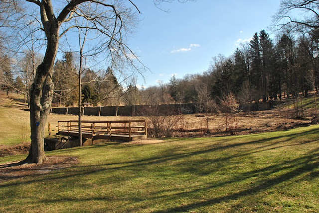
The Upper Wolf's Hollow Trail eventually makes its way back to the open field where I had first started my adventure. Directly to my right and up the small hill is the parking lot. At this point, I crossed over the bridge in the below picture and turned to the west to explore the opposite side of the unnamed creek. Once you cross over the bridge and creek, you'll be on the Octororo Ridge Trail.

Remnants of Schoff Dam. Unfortunately, other than the name, there's not much more information to be found about its history or what it may have been used for other than to create a pond.

 |
| Looking at the Octororo Ridge Trail from the bridge. |
 |
| Signs of spring were beginning to show |
Now on the Octororo Ridge Trail heading in a westerly direction.

At this point, the condition of the trails began to deteriorate and were a bit on the muddy side in this area.


Once you cross over the small bridge in the above picture, the Octororo Ridge Trail takes a sharp turn to the northeast and intersects with the Shortcut Trail which continues alongside the unnamed creek.

Like many of the other parks in the area, hunting is permitted within the grounds of Wolf's Hollow County Park. Please make sure you're aware of this should you decide to explore during hunting season and wear safety gear so you won't be mistaken for someone's dinner!

Like the Octororo Ridge Trail, the Shortcut Trail also takes a turn to the northeast (more north than east). It's not shown on the trail map of the park but at this point, an unnamed trail continues alongside the creek for a distance which I decided to explore.


The unnamed trail runs alongside the creek for maybe a few hundred more yards and leads almost seemingly right into the creek. Although I probably could have kept going, it was at this point where I decided to turn back. A little further downstream from this point is the Octororo Creek.

Returning to the Shortcut Trail, it was time to head up the hill to see the rest of the park.

 |
| Looking back down the hill on the Shortcut Trail |
A short distance down the Octororo Ridge Trail is a spot where you can have a picnic or take a brief rest. According to the trail map, this is one of the five scenic overlooks on the trail but to be honest, there isn't much to look at. Had there been leaves on the trees, there would have been even less to see. I took a quick look at the view and kept moving. At this point, the trail takes a turn to the north.


 |
| White Breasted Nuthatch |
I thought this was pretty cool. I've seen ice like this countless times over my lifetime but this was the first time I've actually been able to photograph it.


Still heading north, the Octororo Ridge Trail eventually intersects with a connecting trail that would bring you east to the Fenceline Trail but for the time being, I continued heading north.


When you reach the northernmost part of the Octororo Ridge Trail, it loops around to the southeast. It's at this point where you'll find another intersecting trail continuing to the north and heading down the hill that I mistakenly thought was a different trail.

This is the view looking back to the Octororo Ridge Trail from the unnamed trail. You can see a sign post on the right side of the trail which I thought was just missing a trail name and decided to continue.


Whoops! A few hundred yards down this unnamed trail was this fence and was where I realized I had to turn back. Thankfully the hill I descended to get to this point wasn't too steep since I now had to climb back up to get back to the Octororo Ridge Trail. Although it wasn't much to see from this vantage point, the Octororo Creek is in the background.

 |
| Tree stand in the woods beyond the fence I ran into |
 |
| Back to the Octororo Ridge Trail and heading southeast |

Gradually, the Octororo Ridge Trail turns to the east, then slightly to the northeast with another connector that would bring you to the Fenceline Trail. Again, I stayed on the Octororo Ridge Trail for the time being.


I'm not sure if I missed the sign or if it wasn't there but once you hike a little further east on the Octororo Ridge Trail, it comes to an end at that point, you can either turn south on a connector to get to the Fenceline Trail, or northeast on the Waterfalls Trail. I turned to the northeast to explore the Waterfalls Trail. After a short distance, the trail takes a turn back to the northwest.
It was at this point where the hike became pretty interesting for a while...

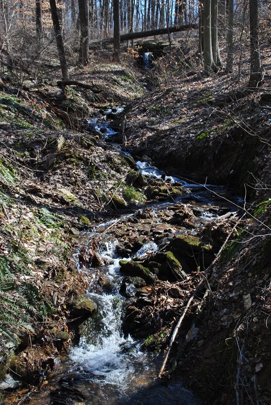
The Waterfalls Trail was in pretty bad shape due to all of the rain and snow causing quite a bit of erosion. This section was probably the most damaged and ran for quite a distance, although not as bad as what you see in the below picture.

Some of it was also a bit on the deceptive side. What looked like sturdy ground turned out to be a few inched of mud. After my first step in it and discovering it was deeper than I wanted to be walking in, I was a bit more careful about where I was walking.


Getting close to the bottom of the hill, the erosion wasn't as bad and the flowing water had receded back to being a small stream from what I would guess was pretty badly flooded at one point to cause that much damage. The small stream created quite a nice view and small waterfall.

Finally making my way to the bottom of the hill, the Waterfalls Trail turns back to the east alongside but not close to the Octororo Creek, at least not at this point.


It was at this point where I realized I had made another mistake. Not with the hiking part but with my camera. Before heading out, I forgot to check to make sure my batteries were charged. It turned out that ALL THREE of them for my one camera were dead! Thankfully, I always carry two cameras with me and was able to continue taking pictures for the duration of my adventure. It would have stunk if I made it this far and had to cut this blog post short due to me forgetting to check my batteries. Safe to say, they all got recharged after returning home!

My other camera (Olympus SZ-12) is much smaller and can fit in my pocket which is where it normally stays while I'm hiking due to some of the glitches I found out about it. It takes fantastic macro pictures but there are times where it won't focus on the subject which is very frustrating, and taking pictures in bright light ended up being way overexposed. I finally figured out how to turn down the exposure to allow less light which certainly helped but it took some experimenting to get it right.
The focusing issue isn't difficult when taking scenic pictures but when you're trying to get a macro shot, it tends to focus on whatever is in the background resulting in blurry pictures. I still haven't figured out if there's a way to fix this problem! Grrrrr!!


Once you get to the bottom of the hill, the Waterfalls Trail turns to the east and levels out. While this section was a bit muddy, it wasn't nearly as bad as the trek down the hill and had little damage.

 |
| My first good view of the Octororo Creek...hmmm, perhaps another spot to go fishing? |
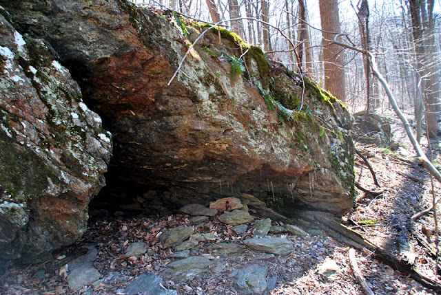
This next series of pictures were the remnants of a building and stone wall. Like the Schoff Dam and other than a mention of possible settlements and forges along the creek on Chester County's website, information about was once there is scarce.


Once I was done checking out the ruins, I continued on my way to the east on the Waterfalls Trail. Take note there's a shooting range (Atglen Sportsmen's Club) close by which can be quite loud in this section of the park.
 |
| Looking upstream on Octororo Creek |
 |
| Looking downstream on Octororo Creek |
The Waterfalls Trail then takes turn to the southwest and heads up a hill. There was some water damage to this section of the trail as well but not nearly as bad as what was seen when first heading down the trail.


As you get towards the top of the hill, there's are a few relatively nice overlooks. It would probably be a bit nicer had there been some leaves on the trees!


I'm not sure why I didn't explore it but at the Gap Overlook, there's another trail (Loop Trail C) that leads down the hill you see below and around the field and circles back to this overlook.

Now at the top of the hill, the Waterfalls Trail comes to an end and meets up with the Fenceline Trail heading west.

The Fenceline Trail runs along the edge of a field and what I believe to be a farm.


Once you get beyond the fence, the Fenceline Trail continues along the edge of the fields, still heading to the west.

The Fenceline Trail briefly takes you through the woods and turns to the south before making another turn to the east and back to the open field.

Once I reached the farmhouse, I turned south on a connecting trail that would bring me back to the Octororo Ridge Trail on a section I hadn't yet explored.

 |
| Heading south on the connecting trail |
Now at the intersecting Octororo Ridge Trail (the yellow box below), I continued heading south


The Octororo Ridge Trail changes directions a few times, eventually making its way to the north and alongside this small pond (at this point, the trail had actually made another turn back to the south). Perhaps during the warmer months, this would be a pretty nice spot to hang out but there was a cold wind blowing through the open field so I didn't stay long.


This sign needs a bit of an explanation. As I continued to the south on the Octororo Ridge Trail, it was face-up on the ground at an intersecting connector trail and alongside a creek...nowhere near any available parking! I hadn't thought about it until I looked at my pictures but if I had taken another picture showing where this sign was, I'm pretty sure the humor I found in its location would be better understood.

The connector trail heads east towards Wolf's Hollow Drive and eventually brings you to a small parking lot.

Once I reached the small parking lot, I took a turn to the north on Wolf's Hollow Road. Almost directly across the street from the parking lot is this home known as the Orchard House (named due to the apple orchards that were once growing there) which is believed to have been the home of a man by the name of John Dunn in the mid 1700's. The home was rebuilt in 1935 for the tenant farmer of the Schoff Dairy Farm (no name was provided).


After taking a few pictures of the Orchard House, I continued north on Wolf's Hollow Road

Thinking the trail was on the inside of the above fence, I cut through this section. I believe there are a number of picnic tables in this area but I don't recall. What I do remember though, was that the ground in this area was pretty soggy.

Once you get to the edge of the fence, you'll find Loop Trail B heading east and away from Wolf's Hollow Road.


Once you reach the end of the fence you see in the above picture, Loop Trail B turns to the south. While it changes directions a few times from southeast to southwest and back again, the primary direction is to the south.

 |
| View of the Orchard House from Loop Trail B |

Loop Trail B cuts through an opening in the fence and at this point, makes one final turn to the southwest. Somewhere in this area is another picnic table and where I finally made a quick stop to grab a snack and change into a pair of dry socks. I didn't stay long though, it was cold on top of this hill!

Now getting close to the parking lot, this is the view of Schoff Dam from the opposite side. What I missed in this area are another set of ruins from an old boathouse that used to be there when the dam wasn't breached.


Once beyond the Schoff Dam, I could see the parking lot but my adventure wasn't over just yet. There was one more trail to explore, known as Loop Trail A.

Loop Trail A skirts around the edge of another open field along Schoff Road and past the main entrance to Wolf's Hollow County Park. It then follows alongside Wolf's Hollow Road until you return to the parking lot area which is across the street from the trail.


 |
| Once last shot of Schoff Dam before calling it a day! |
That was it for my adventure at Wolf's Hollow County Park. In all, it was a good hike and one I'd definitely like to return to. The terrain was various enough to provide a good challenge and the trails were pretty well marked throughout the adventure. The condition of the trails in some areas were pretty bad but in my opinion, no fault of those who work or volunteer their services at the park. There had been a lot of snow and rain (more rain than snow) leading up to my adventure leaving the ground already saturated, creating prime conditions for the amount of erosion I saw during this hike.
Although there are ways to maintain trails in attempt to make sure they don't get destroyed, there's only so much one can do when Mother Nature decides to take her course. There's no way of stopping it from happening if the conditions are right. It's still worth the drive to get out there, just make sure you're aware of the areas where the erosion has occurred and avoid them if you don't want to deal with it.
The reason for not hiking or posting over the last few months was due to re-aggravating a pinched nerve in my neck the day after I went on this adventure. If you've ever pinched a nerve in your neck, you'll also know that the pain can be excruciating and that sitting at a desk for a number of hours was simply out of the question due to how uncomfortable it was. I was having troubles sleeping, couldn't move around well, and finally after a few months of rehab with a massage therapist and chiropractor, things are beginning to return to normal. The pain is gone but I still get an occasional tingling down my right arm. Along with the pinched nerve, taking care of the home now that the weather has gotten warmer has taken up a good amount of time as well. I'll eventually be back on the trail, hopefully soon!
Until next time, happy exploring and happy hiking!
From February, 2019 - Thank you for your posts through the past years.
ReplyDeleteYou are a very good chronicler and a real inspiration.
Since I discovered your e-wanderings a couple years ago, I've followed your steps through several of the byways you've traveled, enjoying every step.
I hope you continue to sojourn in healthy fashion
.
Thanks again for your words and your inspiring sojourning...
- Ken A., Chester Springs, PA