Total Distance: 10.48 Miles
Avg Speed: 1.95 MPH
Avg Moving Speed: 2.27 MPH
Moving Time: 4:37:17
Total Time: 5:22:06
Conditions: Mostly Cloudy, 77 Degrees
Difficulty: Easy, Moderate and Difficult (depending on the trails you choose)
I feel like it's been a month since I last posted about a hike even though it's only been two weeks. Being silly, I neglected my normal "around the house" duties for too long and spent a good part of last weekend paying for it. That, and the weather was forecast to have thunderstorms throughout which didn't transpire until last Sunday evening. I probably could have gone but I didn't want to end up several miles away from shelter with lightning in the area.
I finally did it! I reached my goal of 10 miles in a single hike, next destination, 12 miles! This weekend, I went to the Wissahickon Valley Park and to say the least, this hike has by far topped my list of the most challenging of the season and it was in the middle of the City of Philadelphia! Who would have thought that in the midst of a city there would be such a beautiful natural treasure? I thought my challenge at French Creek State Park was tough but this hike took the prize. There are steep hills, valleys, a lot of rocks and uneven surfaces and I've hardly scratched the surface of the 57 miles of trails in this park.
I've been to the Wissahickon Valley Park a few times previous to this but it was the first time I explored the hills surrounding the Wissahickon Creek and Forbidden Drive. My objective was simple, avoid Forbidden Drive as much as possible. The walk is flat and straight and to me, that's just boring. I did end up there a few times, once because as usual, I took a wrong turn and had to turn back, another was to stop at the Valley Green Inn to purchase a trail map, and the third time was to get to a bridge and cross over the Wissahickon Creek on my hike back to the car. I didn't eat at the Valley Green Inn but their menu looks like there could be some tasty meals coming in the near future.
I started my hike at the Bells Mill Road parking lot on the southwestern side of the creek, the same side Forbidden Drive is on. There's another parking lot on the northeastern side of the creek as well. Approximate address of the parking lot I parked in is:
Philadelphia, PA 19128
There's currently some construction going on in the area and half of this parking lot is blocked off. When or if it's due to be reopened, I don't know. I tried searching the internet for ongoing construction projects in the area but have yet to find anything.

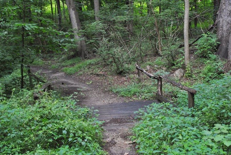
This is on the trail leading down the hill to Forbidden Drive from the parking lot


Once you get to Forbidden Drive, the first grove you'll see has a few of these concrete picnic tables. Just to the left is the Bell's Mill Road bridge crossing over the Wissahickon Creek.

Once I was on Forbidden Drive, I immediately took a right turn onto the first trail heading west up one of the hills that surround the Wissahickon Creek and Forbidden Drive and what a way to start my hike. It was a long and steep incline and got my blood pumping right away.

Many of the trails throughout the area I hiked were similar to this with a lot of rocks and uneven terrain. Make sure that if you decide to hike in the hills that you wear proper hiking shoes and bring water. For the most part, all of the trails I was on were in good condition but the trail markers were a bit sparse.


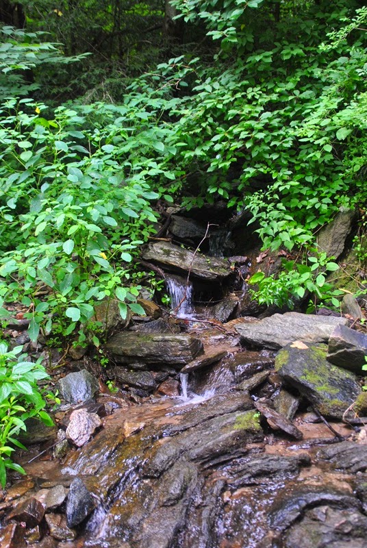
 |
| One of the many small stream crossings throughout the park |

I'm not really sure what this might have been at one time. It looked to be a drain of sorts but there was nothing on the opposite side of the trail and it looks too small to be a spring house.


Below is another of the small stream crossings with Forbidden Drive and the Wissahickon Creek in the background. I took a right at the small bridge, snapped off a few shots and headed back up the next hill.


The terrain throughout the hike was much like this where there were sharp turns, rocks and inclines/declines to traverse. Be sure to watch your step!


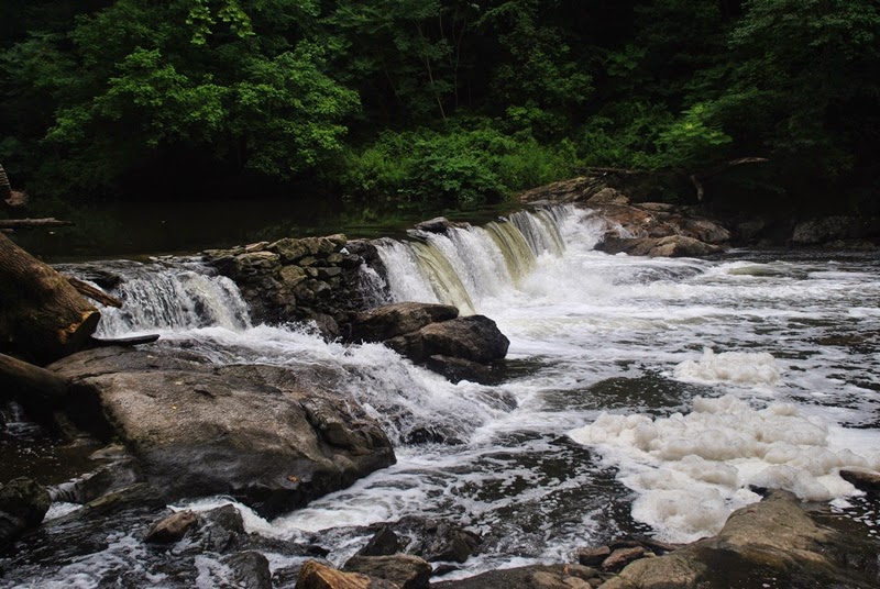
As I came down the hill back onto Forbidden Drive, one of the few waterfalls in the area are just on the other side.


Once I was done at the waterfall, I headed south down Forbidden Drive to the Valley Green Inn to purchase a trail map. If you'd like to purchase one, you can do so at the inn for $10.50 or if you go to the Friends of the Wissahickon website, you can purchase one for $10. The Valley Green Inn accepts credit cards for those of you who may not like to carry cash. Before I got to the inn, I snapped off some more pictures.


If you don't want to park in the parking lot at the Valley Green Inn, there's a small area to park on Wises Mill Road just before you reach Forbidden Drive

Just opposite of Wises Mill Road in the Wissahickon Creek, I saw several of these rock statues (not sure what you'd really call them) and after I was done snapping pictures of them, a gentleman in his car stopped to inform me his son had built them. I told him they just made it to my photo journal but forgot to give him a link to my blog...rats!


 |
| Small hutch approaching the Valley Green Inn |
I should have probably shot another picture of the below zoomed out to give an idea of how high the water mark was. It was just about at eye level and I'm 5'10" tall. That's a lot of water!

Once I purchased my map, I doubled back to the trail I had just been on and headed back to the hills above the creek. This bridge is a short distance upstream from the inn.


This is one approach to the Henry Avenue bridge over this section of the park. Again, there were several small streams flowing through this area.


After passing Henry Drive, I made my way back to Forbidden Drive and headed downstream to find the next bridge.

 |
| Spring house alongside Forbidden Drive |


I stopped at this hutch to take a quick break and to put on a pair of dry socks. Keeping those feet dry is essential to making sure you don't get blisters!

Although I wanted to keep going south, I decided it was time to start heading back to the car.

 |
| View from the bridge looking downstream on the Wissahickon |
 |
| View looking upstream on the Wissahickon |


After snapping pictures of the snakes, I turned back and started heading north to get back to the car.


The rocks and cliffs in this park are strangely kind of wavy and have a multitude of colors. Eventually, I plan to look into how they were formed as they make some very curious shapes.


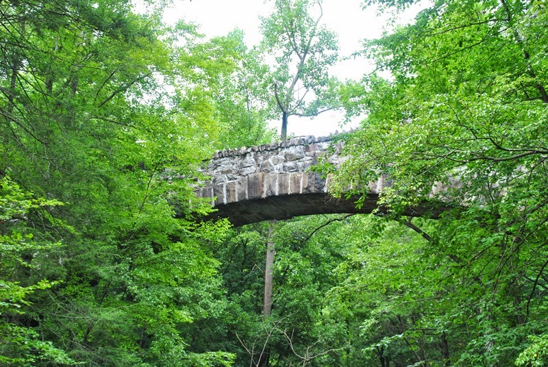
 |
| The approach to the Fingerspan Bridge |

The Fingerspan Bridge over a side stream that drains into the Wissahickon. The bridge was built in 1987 and is 9 feet in height.


Somewhere in this area is a place called the Climbers Rock. I either missed it or saw it and didn't take any pictures.


 |
| Section of the trail that has been washed out by erosion |

Just outside of the Livezey Homestead was another of the waterfalls on the Wissahickon.


I have a little bit of a rant here. I normally don't post pictures of places when I notice there's garbage in them but in this section of the park, there was a LOT of it. Normally, I would pick up what I find but what you'll see below was just a small amount of what I saw in this area. I find it completely disgusting that the same people who take advantage of a natural treasure would also be the same ones who would leave their trash behind on the way out. If you read this and you're one of them, please show some respect, pick up after yourself, and take it with you when you leave. There are trash cans provided in areas throughout the park!
Ok, rant over, I'm off my soap box.
The below staircase is what leads down to what's called the Devil's Pool which is a popular swimming spot for locals, or at least it was until it managed to make the front page of the New York Times in 2011. As I walked through, I saw several people who were jumping off the cliff into the water below. Personally, even though this park is beautiful and although it's probably safe, I wouldn't set foot in that water without waders. According to the Friends of the Wissahickon, 90-95% of the water flowing down the Wissahickon Creek (depending on the season and how much rain has fallen) is coming from seven sewage treatment plants upstream in Montgomery County. In 2002, a study conducted by The Conservation Fund listed it as one of the Schuylkill River's four most polluted tributaries. Of course, 12 years have passed since this study has been conducted and I hope there's been an effort to at least clean some of it up.

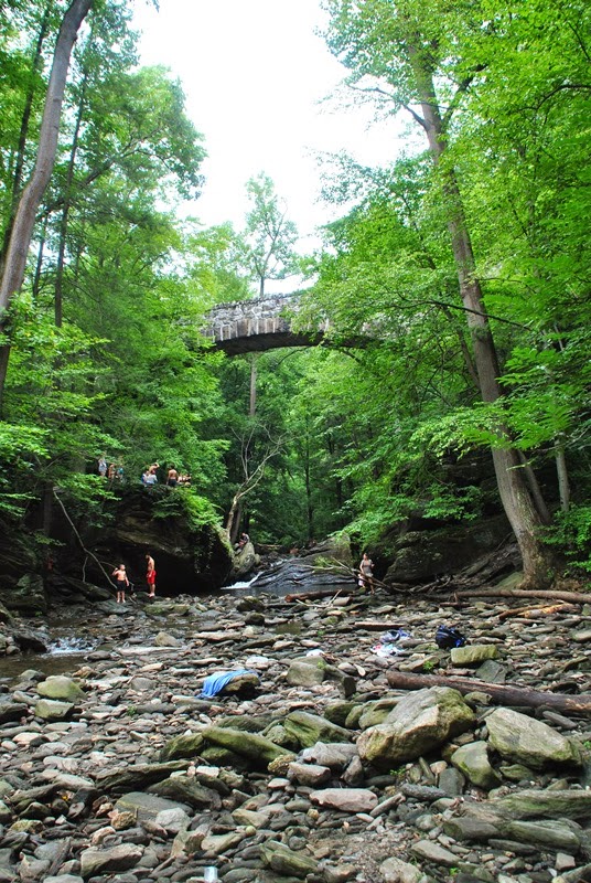 |
| Several people were jumping into the Devil's Pool |
I took a walk up the hill to check out the bridge over Devil's Pool to see if I could look down on it but as you can see, it's been fenced off to keep people out. It turns out this isn't really a bridge but a pipeline carrying sewage.


As I was looking at the above rope swing, I turned to head up the trail and was glad I was watching where I was walking. Right smack in the middle of the trail was this yellow jacket nest which I probably would have stepped on had I not been keeping my eyes open. I took a few pictures and got out of there.


 |
| Small shelter on trail leading back towards Bell's Mill Road |


 |
| This is one of the coolest looking rocks I saw in the park |

On the eastern side of the Wissahickon, the trail splits up into two or three different ones that run relatively parallel to one another. One runs alongside the creek and another two the run further up the hill from the creek.


As I mentioned earlier in my post, I had been to this park on a few occasions previous to this. On those visits, I had tried to locate the Indian Statue and was unable to. This time around with map in hand, I finally found it. Funny enough, I had just missed it on one of my visits and had walked up a trail that intersected with the one that leads there and missed it.


Getting a picture from the front is a bit on the difficult side. The statue is right on the edge of the cliff it's on and opposite of it is a steep hill leading down towards the Wissahickon. Glad my zoom lens works well, I was about 30 or more feet below standing on a steep incline to get this shot. I'll likely return to this area in the late fall or winter so there aren't leaves from trees blocking the view.


Getting a picture of this covered bridge took a little bit of walking through shallow water. From the trail, you can hardly see it.


I'm not sure what happened to this tree but it sure looks like it might have been struck by lightning. The bark was scattered all over the place


This was about it for my hike, the below rock was on the way back up to the parking lot. Another one with some unusual shapes to is although I'm not sure if it was placed there or not.

In all, Wissahickon Valley Park is visually beautiful and I'm already anxious to return giving I've only covered 10 1/2 miles of trails out of the 57 that are there. If you decide to go, one item to note (other than the garbage and the Wissahickon being treated sewage water) is that some of the side streams throughout the park are beautiful but sadly, they also smell of sewage. Whenever I reached a stream that smelled, I took pictures of what I could and kept moving as quickly as possible.
There's a lot more of this park to explore and I'm hoping to return soon (possibly this coming weekend) to continue my adventures. I'm not sure what part of this park is considered the Wissahickon Gorge but I do know there are several more hills to climb and it will be a good challenge for me. I finally reached my 10 mile objective and have set my new one to be 12 miles. Until next time!
Happy adventures and happy hiking!
Please give my Facebook page a like!
No comments:
Post a Comment