Date of Hike: Saturday, August 29, 2015
Total Distance: 11.5 Miles*
Avg speed: Unknown
Avg moving speed: Unknown
Moving Time: Unknown
Total Time: Approximately 5 hours
Conditions: Sunny, 84 Degrees
Difficulty: Easy, Moderate, Difficult
This post is going to be a little different from the rest. I've recently been having some issues with losing my GPS signal while being out on the trail and this time around, I pretty much lost everything. By the time my hike was done, my phone was making noises I had never heard before and was running much slower than it normally does. Although I had statistics from the hike, I forgot to back everything up to my Google Drive before I wiped my phone clean and reinstalled a new ROM.
For those of you who may not be as familiar with technology, the process of wiping a phone clean is similar to starting a computer from scratch again. If you don't back up your data, you lose it and that's what happened with this hike. My GPS tracks were never backed up which is supposed to be done automatically so I lost what statistics I had on the hike as well as any tracks. As noted above, the numbers are either approximate or not available due to my phone going haywire.
With this being said, my adventure this past Saturday brought me to the Coventry Woods Preserve (also known as Coventry Woods Park). This place has been on my radar for a long time and alas, I finally made it out there.
Approximate address where I parked:
2377 Hill Camp Road
Pottstown, PA 19465
GPS: 40.2031737,-75.7187266
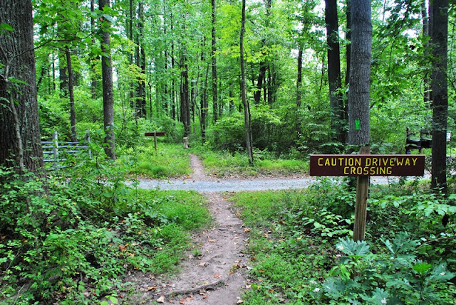
There are a number of places to park throughout the preserve. To locate the parking areas, you can find them on the trail map of the preserve. Also take note that it might be a good idea to avoid the Chestnut Hill Access and Parking area unless you drive an SUV or other vehicle that has a decent amount of clearance. The road that leads to the parking area is unpaved and showing signs of erosion.


Without having a screenshot of the tracks, I'll do my best to guide through the trails I took and the directions I was going. The above two pictures are next to the parking lot on Hill Camps Road. Directly across the street is the Rock Run Trail and the below kiosk.


Just past the kiosk, you have a choice to go either north or south on the trail, I chose to go south.


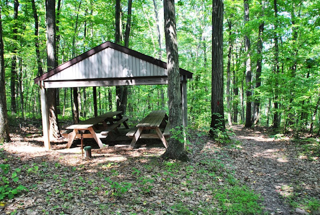
A short distance down the trail is this old pavilion. I didn't take pictures from under the pavilion because of graffiti but it looked like at one time, there used to be restrooms in there.

Just across from the pavilion is this dock and small pond. I'll have to see if I can dig up some information about this area but it looks like at one time, this used to be a day camp or something.


After exploring the pavilion and pond area, the Rock Run Trail eventually makes a turn to the northeast.

Just as you make your turn to the northeast, there's another trail that continues in a southeastern direction alongside Rock Run Creek. Note that this is an unmarked trail that I thought was a portion of the Meadow Trail.

A little common sense goes a long way however. After being on what I thought was the Meadow Trail for a distance and not finding a meadow (no trail markers either), I realized this wasn't it. As you push further into these woods, there are a number of unmarked trails that shoot off in different directions.

I'm not sure if this is Rock Run or another unnamed stream but I crossed over.

Eventually, the trail did bring me out to a meadow but after turning around the treeline to the left side of the below picture, I saw a home. Not knowing if it was private property or part of the preserve, I turned back.

I made my way back to the Rock Run Trail and a short distance northeast of what I originally thought was the Meadow Trail, I located a trail marker. It turns out the Meadow Trail really isn't much of a trail at all and skirts around the edge of a few open fields. I had intentions of checking out the Meadow Trail but after a short walk around one of the fields, I decided to keep moving instead.


Looking back to the first marker for the Meadow Trail

After crossing through the open field, you're back in the woods again, still on the Rock Run Trail

The Rock Run Trail gradually makes a turn to the north, then intersects with the Chestnut Hill Trail where you can go either east or west. I turned to the east.

Throughout many of my recent hikes, I've been spotting a lot of fungus growing on dead trees.


The Chestnut Hill Trail gradually makes a turn to the south and then crosses over Jones Road.


Along the Chestnut Hill Trail, I spotted this bird. Although I can't really tell what kind it is, it was either too young to be flying or its tail feathers were gone (it looked to me like the tail feathers were gone). When it tried to fly, it couldn't go very far.


Eventually, the Chestnut Hill Trail turns to the east, then makes its way to Chestnut Hill Road. Once you're on Chestnut Hill Road, follow it heading north and look for an opening on the right side that's blocked off by a few yellow fence posts and chain.


Walk through the opening between the trees for a distance and to your left, you'll find the below sign and entrance back into the woods. From here, the trail turns to the northeast, then makes another turn to the east.


Shortly after the Chestnut Trail cuts to the east, you'll find these markers indicating the Coventry Trail which merges with the Chestnut Hill Trail if you head north. If you head south, it's just the Coventry Trail and was the direction I went.

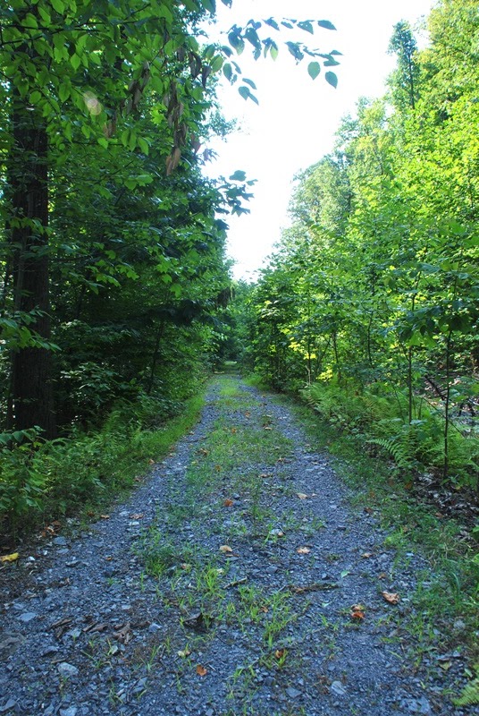
At first, the Coventry Trail is a gravel driveway.

Eventually, the gravel driveway comes to an end and from there, it's all natural surfaced trail.

The Coventry Trail is a bit overgrown with weeds. Be cautious walking on this trail, I stepped on a few broken branches that were hidden by the weeds and rolled under my feet. Luckily, I was able to catch myself before taking a spill.

The Coventry Trail eventually intersects with a connecting trail to a place called Woody's Woods. On my way to the Coventry Woods Preserve, I spotted signs for this place but I wasn't aware it even existed and it's not on Google Maps. I have a new place to explore!


Once you get past the intersecting trail for Woody's Woods, the Coventry Trail gets more difficult to follow. Partly because it's not used much by the looks of it, and also in part because the trail isn't very well marked.

There are markers but they're few and far between and you really have to look for them. Keep your eyes open for these posts with ribbon around them. There were a few areas where I stopped to look around and almost turned back but I kept going and eventually found the markers.

Once the trail comes to a dead end close to Cherry Hill Lane, I turned back to return to the preserve. Alongside the trail is some private property and this car.


A few other items to look for if you check out the Coventry Trail. In some areas, you'll be walking alongside fences (look for private property signs too).

In some other areas, you'll find tress that have been laid alongside the trail that you can also use as a guide.


Back on the merged Coventry and Chestnut Hill Trails, I turned to the north.

A short distance up the trail, there's a small loop called the Collier Trail which I checked out.


Since this is just a small loop, checking out the Collier Trail didn't take long at all and it was back to the merged Coventry and Chestnut Hill Trails continuing north.


Eventually the merged Coventry and Chestnut Hill Trails make their way back to Chestnut Hill Road and another parking space with kiosk. Julia Kirlin granted an easement to North Coventry Township to allow a trail to cross some of her property. Allowing the trail to cut through her property also helped to prevent creating trails through wetlands.

This section of Chestnut Hill Road was one heck of a climb! Although paved and not as difficult as a steep climb on uneven terrain, it was still a good workout.

Once you get to where Chestnut Hill and Coventryville Roads intersect, keep going straight and follow the unpaved road up the hill. This is the parking area I mentioned early on in my post. It doesn't look too bad in the below picture but some of the other areas are more eroded than this.

Once I made my way to this pavilion, I took a break and grabbed a quick snack. This is also where I mistakenly left my towel behind. If you look at the picnic table on the left, you can see it sitting on the ground beneath the right leg. It may seem strange that I'm mentioning a towel but in the last year, I've lost at least four of them on the trail. Most of the time when they're lost, I have no idea when or where but once I noticed it missing this time, I knew exactly where but was too far away to turn back.
Once I left the pavilion, the trail heads to the northwest.

The Love Valley Trail is another loop off the Chestnut Hill Trail, this time a bit larger than the Collier Trail.

Part of why I hiked the Coventry Woods Preserve was to check out some of the historical spots in the area. My other intention was to hike at Warwick County Park once I was done at the preserve since they both share a similar history with charcoal hearths. Unfortunately, the hearths aren't really much to look at. They're just an open circular space about 30-40 feet wide. The only way you might notice them would be the signs signifying their locations.
What is a charcoal hearth though? Back in the day, wood was brought in and organized by girth, then stacked in a specific way. Once stacked, the wood was then covered by leaves and ferns, then by a fine dirt. Once covered, a chimney in the middle was filled with small wood and fired with coals from a campfire. Within about 10-14 days, all of the chemicals but the carbon are driven out of the wood producing charcoal (about 30-40 bundles per cord of wood), and another week or so for the cooling process to take place.
For more information about charcoal hearths, click here.


Once I was done on the Love Valley Trail, I returned to the Chestnut Hill Trail and continued in a northwest direction.

The Chestnut Hill Trail turns to the north and intersects with Fernbrook Lane, then turns to the west again. I went north on Fernbrook Lane.


Originally called Camp Adahi, this camp for young women was built in 1933 after the daughter of Charles Boyer (Mabel) had inquired about why there were camps for boys but not girls. Charles Boyer purchased the property between 1910 and 1928. In 1946, the property was sold to the Evangelical and Reformed Church which then renamed it to Camp Fernbrook.


There were "no trespassing" signs posted on each of the buildings but the windows were low enough that you could get a peek on the inside. Most of what I saw were what looked like old tables and bed frames.


When I first spotted this, I wondered why it was there were these benches and podium that looked like an outdoor area for church. After reading about who had purchased the property, it answered my question.


After walking around the camp for a while and checking out the buildings, it was time to move on. The next trail I explored was the Pigeon Creek Trail which continued northward, then cut to the west.


First crossing over Pigeon Creek heading west towards the Fernbrook Access and Parking area.


At the Fernbrook Access and parking area, I checked out the kiosk station and found some historical tidbits of information.


The Stubblebine House and a pretty interesting history which I won't post here (for the time being) but if you're interested, click here. There's more to this which I'll update when I can.


Once past the Stubblebine House, the Great Oak Trail follows west along St. Peters Road for a short distance, then cuts south through a small field and cutting back to the west once you're in the woods to the left side of this picture.


Eventually, the Great Oak Trail will lead you back to another small section of the Coventry Trail. From there, it continues to the west until it reaches Hill Camp Road.

Follow Hill Camp Road to the south for a distance and once you pass Chestnut Court, you'll see the Furnace Trail to your left heading east back into the preserve.


The Furnace Trail is somewhat of a loop with one section of it continuing east into the preserve and the other portion of the trail heading west back to Hill Camp Road. I continued heading east into the preserve once these two sections of the Furnace Trail intersected.

I didn't take any pictures of the trail in this area. The next trail that intersects with the Furnace Trail is the Chestnut Hill Trail where you can go either northeast or southwest, I turned to the southwest.

This section was probably the most difficult part of the hike with a long steep hill to climb. Funny enough though, most of this hike was heading downhill with the exception of a few steep climbs. What I knew though, was that constantly heading downhill while on a loop trail of sorts, eventually it had to lead back up a hill. This was one of them and it was a good challenge. When I reached the top of the hill, I had to stop to take a break.

These small benches were a short distance down the trail from where I had taken a break. I didn't get a picture of it but when you reach the top of the hill I was referring to, it intersects again with the combined Coventry and Rock Run Trails where I turned to the west again.


A connecting trail then takes you to a combined Coventry and Great Oak trails where I turned to the north.


The combined Coventry and Great Oak Trails intersect with the Furnace Trail where all three trails merge and head north. You also have the choice to turn east back into the preserve on the Furnace Trail or west towards Hill Camp Road on the Great Oak Trail. You could also turn around and head south again but that was the direction I had come from. I turned to the west towards Hill Camp Road.

The Great Oak Trail takes a sharp turn to the south somewhere in this area.

The Great Oak Trail then intersects with the Rock Run Trail where you can turn to the east or keep heading south. I was close to finishing my hike and kept heading south alongside Hill Camp Road.


Continuing south on the Rock Run Trail, you'll cross over Penn's Walk

I'm not sure what this area was and I didn't bother to investigate this time. Perhaps if I return, I can get a closer look but like the buildings at Fernbrook, there are "no trespassing" signs posted.


Just about back to the car. If you look between the trees in the middle right side, you can see the kiosk station where I first jumped on the Rock Run Trail.

That was it for my hike at the Coventry Woods Preserve. I honestly didn't think I'd be able to hike more than 11 miles with this preserve said to only be about 660 acres. Of course, I managed to hike over 13 miles at Tyler Arboretum last year (approximately 650 acres) so I suppose I shouldn't be surprised that I did. I had intentions of going to Warwick County Park after hiking at the preserve but decided to save that for another day.
In all, the Coventry Woods Preserve is very nice and with the exception of the Coventry Trail, the trails were in very good condition for the most part (note that some of the trails are also equestrian). There are a few unmarked trails within the preserve that you'll have to watch for if you don't want to end up getting turned around or lost. I'd definitely like to return to check out some of the trails that I missed this time around although I did my best to cover as much of them as possible.
Until next time, happy exploring and happy hiking!
Please give my Facebook page a like!
This post is going to be a little different from the rest. I've recently been having some issues with losing my GPS signal while being out on the trail and this time around, I pretty much lost everything. By the time my hike was done, my phone was making noises I had never heard before and was running much slower than it normally does. Although I had statistics from the hike, I forgot to back everything up to my Google Drive before I wiped my phone clean and reinstalled a new ROM.
For those of you who may not be as familiar with technology, the process of wiping a phone clean is similar to starting a computer from scratch again. If you don't back up your data, you lose it and that's what happened with this hike. My GPS tracks were never backed up which is supposed to be done automatically so I lost what statistics I had on the hike as well as any tracks. As noted above, the numbers are either approximate or not available due to my phone going haywire.
With this being said, my adventure this past Saturday brought me to the Coventry Woods Preserve (also known as Coventry Woods Park). This place has been on my radar for a long time and alas, I finally made it out there.
Approximate address where I parked:
2377 Hill Camp Road
Pottstown, PA 19465
GPS: 40.2031737,-75.7187266
There are a number of places to park throughout the preserve. To locate the parking areas, you can find them on the trail map of the preserve. Also take note that it might be a good idea to avoid the Chestnut Hill Access and Parking area unless you drive an SUV or other vehicle that has a decent amount of clearance. The road that leads to the parking area is unpaved and showing signs of erosion.


Without having a screenshot of the tracks, I'll do my best to guide through the trails I took and the directions I was going. The above two pictures are next to the parking lot on Hill Camps Road. Directly across the street is the Rock Run Trail and the below kiosk.


Just past the kiosk, you have a choice to go either north or south on the trail, I chose to go south.


A short distance down the trail is this old pavilion. I didn't take pictures from under the pavilion because of graffiti but it looked like at one time, there used to be restrooms in there.

Just across from the pavilion is this dock and small pond. I'll have to see if I can dig up some information about this area but it looks like at one time, this used to be a day camp or something.


After exploring the pavilion and pond area, the Rock Run Trail eventually makes a turn to the northeast.

Just as you make your turn to the northeast, there's another trail that continues in a southeastern direction alongside Rock Run Creek. Note that this is an unmarked trail that I thought was a portion of the Meadow Trail.

A little common sense goes a long way however. After being on what I thought was the Meadow Trail for a distance and not finding a meadow (no trail markers either), I realized this wasn't it. As you push further into these woods, there are a number of unmarked trails that shoot off in different directions.

I'm not sure if this is Rock Run or another unnamed stream but I crossed over.

Eventually, the trail did bring me out to a meadow but after turning around the treeline to the left side of the below picture, I saw a home. Not knowing if it was private property or part of the preserve, I turned back.

I made my way back to the Rock Run Trail and a short distance northeast of what I originally thought was the Meadow Trail, I located a trail marker. It turns out the Meadow Trail really isn't much of a trail at all and skirts around the edge of a few open fields. I had intentions of checking out the Meadow Trail but after a short walk around one of the fields, I decided to keep moving instead.


Looking back to the first marker for the Meadow Trail

After crossing through the open field, you're back in the woods again, still on the Rock Run Trail

The Rock Run Trail gradually makes a turn to the north, then intersects with the Chestnut Hill Trail where you can go either east or west. I turned to the east.

 |
| Red trail marker for the Chestnut Hill Trail |
Throughout many of my recent hikes, I've been spotting a lot of fungus growing on dead trees.


The Chestnut Hill Trail gradually makes a turn to the south and then crosses over Jones Road.

 |
| Jones Road trail access |

Along the Chestnut Hill Trail, I spotted this bird. Although I can't really tell what kind it is, it was either too young to be flying or its tail feathers were gone (it looked to me like the tail feathers were gone). When it tried to fly, it couldn't go very far.


 |
| More mushrooms/fungus |

Eventually, the Chestnut Hill Trail turns to the east, then makes its way to Chestnut Hill Road. Once you're on Chestnut Hill Road, follow it heading north and look for an opening on the right side that's blocked off by a few yellow fence posts and chain.


Walk through the opening between the trees for a distance and to your left, you'll find the below sign and entrance back into the woods. From here, the trail turns to the northeast, then makes another turn to the east.


Shortly after the Chestnut Trail cuts to the east, you'll find these markers indicating the Coventry Trail which merges with the Chestnut Hill Trail if you head north. If you head south, it's just the Coventry Trail and was the direction I went.

At first, the Coventry Trail is a gravel driveway.
Eventually, the gravel driveway comes to an end and from there, it's all natural surfaced trail.

The Coventry Trail is a bit overgrown with weeds. Be cautious walking on this trail, I stepped on a few broken branches that were hidden by the weeds and rolled under my feet. Luckily, I was able to catch myself before taking a spill.

The Coventry Trail eventually intersects with a connecting trail to a place called Woody's Woods. On my way to the Coventry Woods Preserve, I spotted signs for this place but I wasn't aware it even existed and it's not on Google Maps. I have a new place to explore!


Once you get past the intersecting trail for Woody's Woods, the Coventry Trail gets more difficult to follow. Partly because it's not used much by the looks of it, and also in part because the trail isn't very well marked.

 |
| I would assume this used to be a trail marker for the Coventry Trail |
There are markers but they're few and far between and you really have to look for them. Keep your eyes open for these posts with ribbon around them. There were a few areas where I stopped to look around and almost turned back but I kept going and eventually found the markers.

 |
| This was pretty much the end of the trail |
Once the trail comes to a dead end close to Cherry Hill Lane, I turned back to return to the preserve. Alongside the trail is some private property and this car.


A few other items to look for if you check out the Coventry Trail. In some areas, you'll be walking alongside fences (look for private property signs too).

In some other areas, you'll find tress that have been laid alongside the trail that you can also use as a guide.

 |
| Ribbon tied around trees in some areas |


Back on the merged Coventry and Chestnut Hill Trails, I turned to the north.

 |
| Leaves are starting to change colors! |
A short distance up the trail, there's a small loop called the Collier Trail which I checked out.


Since this is just a small loop, checking out the Collier Trail didn't take long at all and it was back to the merged Coventry and Chestnut Hill Trails continuing north.


Eventually the merged Coventry and Chestnut Hill Trails make their way back to Chestnut Hill Road and another parking space with kiosk. Julia Kirlin granted an easement to North Coventry Township to allow a trail to cross some of her property. Allowing the trail to cut through her property also helped to prevent creating trails through wetlands.

This section of Chestnut Hill Road was one heck of a climb! Although paved and not as difficult as a steep climb on uneven terrain, it was still a good workout.

Once you get to where Chestnut Hill and Coventryville Roads intersect, keep going straight and follow the unpaved road up the hill. This is the parking area I mentioned early on in my post. It doesn't look too bad in the below picture but some of the other areas are more eroded than this.

Once I made my way to this pavilion, I took a break and grabbed a quick snack. This is also where I mistakenly left my towel behind. If you look at the picnic table on the left, you can see it sitting on the ground beneath the right leg. It may seem strange that I'm mentioning a towel but in the last year, I've lost at least four of them on the trail. Most of the time when they're lost, I have no idea when or where but once I noticed it missing this time, I knew exactly where but was too far away to turn back.

Once I left the pavilion, the trail heads to the northwest.

The Love Valley Trail is another loop off the Chestnut Hill Trail, this time a bit larger than the Collier Trail.

 |
| Orange trail markers for the Love Valley Trail |
 |
| The Love Valley Trail loop starts going either northwest or northeast, I went to the northeast (right) |
Part of why I hiked the Coventry Woods Preserve was to check out some of the historical spots in the area. My other intention was to hike at Warwick County Park once I was done at the preserve since they both share a similar history with charcoal hearths. Unfortunately, the hearths aren't really much to look at. They're just an open circular space about 30-40 feet wide. The only way you might notice them would be the signs signifying their locations.
What is a charcoal hearth though? Back in the day, wood was brought in and organized by girth, then stacked in a specific way. Once stacked, the wood was then covered by leaves and ferns, then by a fine dirt. Once covered, a chimney in the middle was filled with small wood and fired with coals from a campfire. Within about 10-14 days, all of the chemicals but the carbon are driven out of the wood producing charcoal (about 30-40 bundles per cord of wood), and another week or so for the cooling process to take place.
For more information about charcoal hearths, click here.


Once I was done on the Love Valley Trail, I returned to the Chestnut Hill Trail and continued in a northwest direction.

The Chestnut Hill Trail turns to the north and intersects with Fernbrook Lane, then turns to the west again. I went north on Fernbrook Lane.


Originally called Camp Adahi, this camp for young women was built in 1933 after the daughter of Charles Boyer (Mabel) had inquired about why there were camps for boys but not girls. Charles Boyer purchased the property between 1910 and 1928. In 1946, the property was sold to the Evangelical and Reformed Church which then renamed it to Camp Fernbrook.


There were "no trespassing" signs posted on each of the buildings but the windows were low enough that you could get a peek on the inside. Most of what I saw were what looked like old tables and bed frames.

 |
| This building looked like it was still in use |


When I first spotted this, I wondered why it was there were these benches and podium that looked like an outdoor area for church. After reading about who had purchased the property, it answered my question.


After walking around the camp for a while and checking out the buildings, it was time to move on. The next trail I explored was the Pigeon Creek Trail which continued northward, then cut to the west.

 |
| Yellow trail markers for the Pigeon Creek Trail |
 |
| Tree identification, perhaps this could be made into a game? |

First crossing over Pigeon Creek heading west towards the Fernbrook Access and Parking area.


At the Fernbrook Access and parking area, I checked out the kiosk station and found some historical tidbits of information.


 |
| Old school gas pump! |
 |
| I'm not sure what this was at one time, perhaps an outhouse? |
The Stubblebine House and a pretty interesting history which I won't post here (for the time being) but if you're interested, click here. There's more to this which I'll update when I can.


Once past the Stubblebine House, the Great Oak Trail follows west along St. Peters Road for a short distance, then cuts south through a small field and cutting back to the west once you're in the woods to the left side of this picture.


Eventually, the Great Oak Trail will lead you back to another small section of the Coventry Trail. From there, it continues to the west until it reaches Hill Camp Road.

Follow Hill Camp Road to the south for a distance and once you pass Chestnut Court, you'll see the Furnace Trail to your left heading east back into the preserve.


 |
| Blue trail markers indicating the Furnace Trail |

The Furnace Trail is somewhat of a loop with one section of it continuing east into the preserve and the other portion of the trail heading west back to Hill Camp Road. I continued heading east into the preserve once these two sections of the Furnace Trail intersected.

I didn't take any pictures of the trail in this area. The next trail that intersects with the Furnace Trail is the Chestnut Hill Trail where you can go either northeast or southwest, I turned to the southwest.

This section was probably the most difficult part of the hike with a long steep hill to climb. Funny enough though, most of this hike was heading downhill with the exception of a few steep climbs. What I knew though, was that constantly heading downhill while on a loop trail of sorts, eventually it had to lead back up a hill. This was one of them and it was a good challenge. When I reached the top of the hill, I had to stop to take a break.

These small benches were a short distance down the trail from where I had taken a break. I didn't get a picture of it but when you reach the top of the hill I was referring to, it intersects again with the combined Coventry and Rock Run Trails where I turned to the west again.


A connecting trail then takes you to a combined Coventry and Great Oak trails where I turned to the north.


The combined Coventry and Great Oak Trails intersect with the Furnace Trail where all three trails merge and head north. You also have the choice to turn east back into the preserve on the Furnace Trail or west towards Hill Camp Road on the Great Oak Trail. You could also turn around and head south again but that was the direction I had come from. I turned to the west towards Hill Camp Road.

The Great Oak Trail takes a sharp turn to the south somewhere in this area.

The Great Oak Trail then intersects with the Rock Run Trail where you can turn to the east or keep heading south. I was close to finishing my hike and kept heading south alongside Hill Camp Road.


Continuing south on the Rock Run Trail, you'll cross over Penn's Walk


I'm not sure what this area was and I didn't bother to investigate this time. Perhaps if I return, I can get a closer look but like the buildings at Fernbrook, there are "no trespassing" signs posted.


Just about back to the car. If you look between the trees in the middle right side, you can see the kiosk station where I first jumped on the Rock Run Trail.

That was it for my hike at the Coventry Woods Preserve. I honestly didn't think I'd be able to hike more than 11 miles with this preserve said to only be about 660 acres. Of course, I managed to hike over 13 miles at Tyler Arboretum last year (approximately 650 acres) so I suppose I shouldn't be surprised that I did. I had intentions of going to Warwick County Park after hiking at the preserve but decided to save that for another day.
In all, the Coventry Woods Preserve is very nice and with the exception of the Coventry Trail, the trails were in very good condition for the most part (note that some of the trails are also equestrian). There are a few unmarked trails within the preserve that you'll have to watch for if you don't want to end up getting turned around or lost. I'd definitely like to return to check out some of the trails that I missed this time around although I did my best to cover as much of them as possible.
Until next time, happy exploring and happy hiking!
Please give my Facebook page a like!
Thank you for the walk down memory lane. The history of this United Church of Christ camp goes back past when I attended it for a week at time in the summer in the 1970's. It was owned by the Pennsylvania Southeast Conference of the United Church of Christ Churches until the Spanish Churches bought it from them. It was a summer camp. And they also had a conference center over near the ponds that was operated year round. And if you dare you could stay at the lodge three seasons with your church group. It was called Camp Fernbrook. It was the highlight of my summer and about a dozen of my friends from church. I still think of the place and often think of it as my "happy place". In the pictures the one place you have a picture of is the outside shower and bathrooms. The only shower and bathrooms!! And it was only cold water!! The small cabins at the end were used for housing either staff or when they had specific weeks like rowing week etc they would bunk them in there. Thanks for the wonderful trip down memory lane!
ReplyDeleteBarbara, thank you for providing me with some additional insight about the camp. I'm glad to have brought some fond memories back to you although I wouldn't want to be taking cold showers! Thanks for stopping in!
Delete