Date of Hike: Monday, September 7, 2015
Total Distance: *6.8 Miles
Avg speed: Unknown
Avg moving speed: Unknown
Moving Time: Unknown
Total Time: *3.4 Hours
Conditions: Sunny, 88 Degrees
Difficulty: Easy, Moderate
*Once again, the numbers from my hike at Warwick County Park are approximate, this time by my own doing. Unbeknownst to me and due to the recent issues I had been having with my phone losing its GPS signal (more accurately, the app I use), I checked to make sure the app on my phone was tracking my progress properly and when I placed it back in my pocket, I somehow managed to pause it. I estimate that I hiked about 4/10 of a mile before realizing it (top center missing red line). Rats!! Not a real big deal since I'm not trying to compete with my best time or anything but I do like to have a somewhat accurate number of the miles I hiked and to know the trails I was on.
As I already mentioned, my adventure took me to the Warwick County Park this past Monday. I've had my eye on this place for quite a while and have actually been there a number of times in the past but never to explore the trails. A few weeks ago, I hiked the Horse-Shoe Trail from St. Peters Village to Welkinweir which took me right through the middle of Warwick County Park and also through some historical areas which peaked my interest in exploring and learning a little more about the area.
There are four different places to park at Warwick County Park (technically, there are five but two of them are in the same area by the main entrance). To locate the parking lots, take a look at the trail map. Take note that the parking lot that's shown in the southwestern side of the park is a maintenance area and was closed off by a gate when I was there this past Monday. I parked in the main parking lot. The approximate address is:
191 County Park Road
Pottstown, PA 19465
GPS: 40.167691, -75.724118
If you use Google Maps like I do, take note that the above address will place a marker in the middle of the woods at the park but this is the address that's on the sign at the main entrance. The GPS coordinates will put you on County Park Road at the entrance.

Since I parked in the main parking lot, I started my adventure heading west towards County Park Road. In this section of Warwick County Park, there are open grasslands and some wetlands as well, that is, when it rains which it hadn't done in some time.

With the summer season coming to an end, the plants and flowers are slowly starting to fade out and turn colors.

There were still some flowers in bloom though.


I've been seeing a lot of butterflies recently. Like everything else, it seems they're getting prepared for the end of the season.

I've also noticed that the wings on the butterflies are getting pretty torn up.


The trail eventually leads you into a wooded area and eventually alongside French Creek. In this area, French Creek is so narrow, you can almost jump across some areas.


Just below the bridge, there were a number of fish swimming around. I believe these are shiners.


By now, I had turned back and was heading east alongside French Creek. There are a number of rock dams in the area which widened the creek.

Looking downstream again on French Creek with a fishing deck on the right side. There are a few nice fishing spots in this section of the creek.

Both the creek and the trail turn to the north, then back to the east again. Much of this portion of the hike was in full sunlight which on a hot day can be pretty toasty.


Back alongside French Creek again. Under normal conditions, I'm not sure it would have been possible but instead of circling back to the parking lot which I had intended on doing, I crossed over the rock dam and hit the trails on the opposite side. There hadn't been much rain recently so the creek was below normal levels.

Once I crossed over the creek, I turned back to the west. There's a nice overlook of French Creek but the view is blocked by trees and not picture-worthy. This was about the area where I had checked my phone to make sure it was tracking my progress and mistakenly paused the tracking app.


Eventually, the trail turned towards the northeast in the direction of one of the parking lots that are alongside Ridge Road (State Route 23).

In this area, you're cutting through some more open grassland and a mix of wooded areas.


This is the north access for the park, as if this isn't obvious. The parking lot is pretty small but in all the times I've driven past it, I don't think I've ever seen it full.


Once the trail turns to the east, you'll be hiking through more open fields for the time being.

Throughout Warwick County Park, there are a number of ruins but this was the only one I was able to find. Perhaps I may return in the winter to see if the others are more visible.


The rest of the hike on the northern side of Warwick County Park heads in a east/west direction and is relatively flat and straight. I was still hiking to the east.


This I found to be interesting. Over my last few hikes, I've seen this a number of times. In the middle of the trails, there were earthworms everywhere. Had I wanted to go fishing, I would have had an endless supply of bait!

A few weeks ago, I noticed these patterns in the dirt along the trails but had no idea where they had come from since I didn't see any earthworms. After seeing the earthworms all over the place, I think it's safe to say I figured it out.


Somewhere along this trail, there's supposed to be a turn-off trail that will take you alongside French Creek. I had intentions of checking this trail out but I either missed the turn or the trail isn't being maintained anymore.


The trail on the north side of Warwick County Park comes to an end at the Mt. Pleasant Road parking lot.

I followed Mt. Pleasant Road south, crossing over French Creek until I reached the Horse-Shoe Trail on the opposite side, then turned back to the west. I didn't take many pictures in the this area since I had already been through there when I hiked the Horse-Shoe Trail from St. Peters Village to Welkinweir.


The Horse-Shoe Trail turns to the southwest and intersects with the Charcoal Trail which makes a turn to the east and was the trail I followed.

This was the first real challenge of this hike. While it wasn't too steep, this hill was good enough to get the blood pumping.

The Charcoal Trail also intersects with another unnamed trail (maybe) and continues to the east to an open field.

I'm not sure what Sky's Loop is and can't find any information about it on the internet so I may return to find out. This sign was next to the side trail I was on, just on the edge of an open field. I had taken a picture of the field but unfortunately, with the sun being as bright as it was, the picture ended up being overexposed.

The side trail to this "Sky's Loop" was relatively short so I turned back to the Charcoal Trail which by now was headed in a southwest direction.


This is another side trail that led to the south access gate on Mt. Pleasant Road somewhere in here.

The Charcoal Trail splits off in two directions with one heading north leading back to the Horse-Shoe Trail and the other continuing to the west which was the direction I kept going.


There were a lot of rocks alongside this section of the Charcoal Trail.


Within this area, there's a lot of historical references to the iron industry and one of my reasons for wanting to return to Warwick County Park. I don't need a reason, if there's a trail, I want to check it out! They're not in any particular order but they explain the process of making charcoal for the local iron forges that were in the area at the time. Note that the information I obtained was taken from the signs scattered throughout this section of the park.
Southeastern Pennsylvania produced the most iron in the colonies and nation just before and after the Revolutionary War. Approximately 27,000 tons of iron was produced in 1810 which took approximately 4,100 acres of wood processed into charcoal.
During the fall and depending on demand, up to 350 acres of land were selected for cutting on an annual basis which would supply up to 5,000 cords of wood. Plots of trees were selected and cut in a checkerboard pattern to avoid clear cutting and to allow for new growth.
An acre of timber would yield approximately 30 cords of wood which in turn would produce about 1,200 bushels of charcoal. The 1,200 bushels of charcoal would produce approximately 6 2/3 tons of pig iron.
If you check out the above numbers, the math doesn't add up. According to the information provided on the signs, an acre of timber would produce approximately 30 cords of wood and 350 acres produced 5,000 cords. If you do the math, 30 cords per acre of wood and 350 acres is 10,500 cords. Obviously, one would need to take into account that trees are never the same size but that's a pretty big difference in numbers.


This is one of the numerous charcoal hearths scattered throughout the park as well as the many that you'll find throughout the entire area. Over the last few weeks, I've hiked at a few places (Coventry Woods Preserve, Woody's Woods) in the vicinity, each of which have had charcoal hearths.
I mentioned this in my post about Woody's Woods but if you don't know they exist, you may end up walking right past the remnants of a hearth without even realizing it's there. This makes me wonder how many I may have walked past in my previous adventures in the area before knowing what they were (French Creek State Park, Crow's Nest Preserve, Birdsboro Waters and Preserve, St. Peters Village). More detailed information about what a hearth is will be below.

During the winter, wood was usually cut and allowed to dry before operations began in late spring. The "woodchoppers" and "jack fellers" would cut the trees down, then "woodhaulers" would drag the trees to a clearing where "sawyers" processed them into four foot lengths.
There were two different sizes of wood which were referred to as "lap-wood" (smaller pieces like branches), and "billets" (trunks of trees). The cords of wood were separated by upright poles in order to allow for counting.

While taking a trip into history, I was still heading to the west on the Charcoal Trail/Iron Heritage Trail.

In the spring, a "collier" who was among the most skilled of the iron workers would prepare a suitable spot in the forest to build a hearth. It would have to be level, dry and protected from the wind (as well as being close to a wood pile). Their experience was required for knowing how to properly build, maintain, and recognize the various stages of creating charcoal including the color and smell of the mound (hearth) while burning.
I've already shown a few pictures of hearths over the last few weeks which don't look like much more than a flat space about 30-40 feet in diameter. A space used for creating a hearth had to be clear of trees, brush, roots, stumps, and any animal burrows were filled in to prevent oxygen from getting into the hearth during the burn.

Charcoal was produced during the summer months. In the center of the hearth, an internal chimney approximately 6-8 feet tall was built and in the center of that was a 10-15 foot pole known as a "fagan". Once the chimney was built, the collier and "charcoal helpers" packed billets against the chimney together as tightly a possible to avoid air pockets.
Additional layers were then stacked on top of the first layer until the mound was about 25 feet in diameter. Once this was completed, the next steps were to cover the wood pile with leaves and then dry soil. With the exception of a few carefully placed vent holes, the mound was air tight creating a self-made kiln.
At regular intervals, embers were dropped through a "clamp" on the top of the pile until they were red hot. Once this happened, the clamp was sealed. After 10 or so days, the collier would poke the fagan through the vent holes and if the "chingle" of finished coal was heard, the hearth was slowly opened which would occur over a number of days as the pile slowly cooled.
Once this process was completed, bushel baskets were filled with the charcoal and placed on a wagon where it was "teamed" (transported) to the furnaces.

A collier was the second highest paid worker of the iron industry next to the furnacemen. With that, the colliers job was to monitor the hearths 24 hours a day for blue smoke during the day and burning embers at night. If any air was to get into the hearth during the charcoal making process, the wood would burn to ash making it useless.
During the burn, the collier would live in a hut close to the hearths so that they could monitor them regularly.

The Fink Truss "bridge to nowhere" used to cross French Creek at one time but has since been moved to where it currently sits now, south of the main parking lot.

In the 1700's and 1800's, more than a dozen iron plantations were established in northern Chester County. The products created at the plantations were used throughout the country and the world.
Developed by Samuel Reeves, the Phoenix Column which was developed at the Northern Chester County Phoenix Iron Works, provided the skeletal framework for the Washington Monument in 1848 and the Eiffel Tower in 1889.
Iron also played a critical role in the American Revolution, the War of 1812 and the Civil War. From 1776-1777 approximately 100 "great guns" were cast at Hopewell Furnace. Iron was also used to cast stoves and hollow ware such as pots and kettles.
Due to the iron industry, the many trails you'll see throughout Chester County connected the hearths, forges and furnaces by the 1800's with one of those trails being the Horse-Shoe Trail.
To take note of this, I noticed these trails during my recent adventures throughout this part of Chester County were about the width of a single vehicle and thought that this might have been the reason for them. Reading about it confirms what my thoughts were.


Once I passed the Fink Truss bridge, I continued heading west until I reached a bench at the top of a hill to the southwest of the main parking lot and took a quick break. While I was at the bench and since the view from the top of this small hill is pretty nice, I decided to experiment with a function on one of my cameras that takes panoramic pictures.
Unfortunately, my picture experiment didn't turn out like I had hoped. The panoramic function of this camera requires taking more than one picture which then gets stitched together automatically. Keeping the camera at the same angle isn't as easy as it looks! If you look in the center of this picture, you can see in the tree line and field that I dipped my camera which makes it look like everything is caving into the middle. It's an ok picture but the dip isn't supposed to be there!

Directly behind the bench, you'll find an unmarked trail which I decided to check out. Like the rest of the trails in this area, they look like they used to be the old roadways between the hearths, etc., only overgrown since they're not being maintained.

While walking through the woods in this area, you can see remnants of these trails heading in different directions, one of which led back towards County Park Road and another leading up a hill towards the southwestern section of the park. I didn't get very far after turning back though, The trails are there but they're overgrown.


After checking out the unmarked trails and looping past the main parking lot, I was heading east back into the woods on the Adirondack Tree ID and Iron Heritage Trails. I wasn't interested in identifying the trees though!

Ready for some more history? During the 1700's and early 1800's, charcoal and water power were sources of commerce, including the iron industry. The hardwood forests of Pennsylvania and the fast moving creeks in the area provided the fuel and drove the machinery needed for creating and refining pig iron into essential tools, building materials and utensils needed to build the new country.
As early as 1681, William Penn had taken note that the country was thought to be capable of producing iron as one of its commodities. After being settled by Penn in 1682, Chester County became a center for iron production.
In 1717, Coventry Forge was built and was one of the earliest forges established in the colonies. In all, 22 documented furnaces were built alongside the many streams and creeks in southeastern Pennsylvania.

I entered back into the woods heading east on the Adirondack/Iron Heritage Trail.


This is a bat house but I didn't see any bats in there. If you look at the floor however, you can tell they were. The dark spots on the floor of the bat house is bat droppings, known as guano.

Before you reach the above bat house, the Adirondack/Iron Heritage trail cuts to the southwest. Once you pass the bat house, there's another trail which according to the map is also part of the tree identification but is not being maintained. Being curious, I took the less beaten path and checked it out.


Back to a little more history. If I haven't lost you yet, it's almost over! Charcoal is a fuel that burns hotter than wood and is the result of heat eliminating the oxygen and hydrogen from it through a slow baking process (charcoal hearths). It is used for smelting iron from its ore in a blast furnace. Iron production began around 1300 B.C.
The hardwoods found in Pennsylvania produced the highest quality and quantity of charcoal to fuel the ironworks and the area around Warwick County park provided the wood and land needed to build the hearths to make charcoal.

By now, I was headed south on the Iron Heritage Trail, back towards the Horse-Shoe Trail.


This sign is a basic overview of what happened throughout each season with the charcoal production process which has already been explained. If you have further interest in the iron making industry in Pennsylvania, check out this page on the Explore PA History website.

Back to the trails! Eventually, the Iron Heritage Trail led me back to the Horse-Shoe Trail which I followed heading south, then back to the west until I reached the main parking lot of Warwick County Park.


Once out to the parking lot, I cut behind one of the pavilions and found another trail that unfortunately led me to a dead end.

I hiked past the parking lot for the time being and covered a portion of trail (Red Cliff Trail) that I hadn't been on earlier in the day. Eventually, it brought me back to where I had crossed over French Creek when I first started my hike.

That was it for my adventure through history and Warwick County Park. In all, it was an excellent hike and one that I'd eventually like to return to. The trails are in very good condition, if not excellent, are well maintained with the exception of one, and of course there's the history of the iron industry as well as the Horse-Shoe Trail. My only word of "caution" would be to make sure you put on some sunscreen if you decide to go there on a sunny day since there are a number of trails that are in full sunlight, especially the western and northern sides of the park.
Until next time, happy exploring and happy hiking!
Please give my Facebook page a like!
*Once again, the numbers from my hike at Warwick County Park are approximate, this time by my own doing. Unbeknownst to me and due to the recent issues I had been having with my phone losing its GPS signal (more accurately, the app I use), I checked to make sure the app on my phone was tracking my progress properly and when I placed it back in my pocket, I somehow managed to pause it. I estimate that I hiked about 4/10 of a mile before realizing it (top center missing red line). Rats!! Not a real big deal since I'm not trying to compete with my best time or anything but I do like to have a somewhat accurate number of the miles I hiked and to know the trails I was on.
As I already mentioned, my adventure took me to the Warwick County Park this past Monday. I've had my eye on this place for quite a while and have actually been there a number of times in the past but never to explore the trails. A few weeks ago, I hiked the Horse-Shoe Trail from St. Peters Village to Welkinweir which took me right through the middle of Warwick County Park and also through some historical areas which peaked my interest in exploring and learning a little more about the area.
There are four different places to park at Warwick County Park (technically, there are five but two of them are in the same area by the main entrance). To locate the parking lots, take a look at the trail map. Take note that the parking lot that's shown in the southwestern side of the park is a maintenance area and was closed off by a gate when I was there this past Monday. I parked in the main parking lot. The approximate address is:
191 County Park Road
Pottstown, PA 19465
GPS: 40.167691, -75.724118
If you use Google Maps like I do, take note that the above address will place a marker in the middle of the woods at the park but this is the address that's on the sign at the main entrance. The GPS coordinates will put you on County Park Road at the entrance.

Since I parked in the main parking lot, I started my adventure heading west towards County Park Road. In this section of Warwick County Park, there are open grasslands and some wetlands as well, that is, when it rains which it hadn't done in some time.

With the summer season coming to an end, the plants and flowers are slowly starting to fade out and turn colors.

There were still some flowers in bloom though.


I've been seeing a lot of butterflies recently. Like everything else, it seems they're getting prepared for the end of the season.

I've also noticed that the wings on the butterflies are getting pretty torn up.


The trail eventually leads you into a wooded area and eventually alongside French Creek. In this area, French Creek is so narrow, you can almost jump across some areas.


 |
| County Park Road bridge over French Creek |
Just below the bridge, there were a number of fish swimming around. I believe these are shiners.


 |
| Looking downstream on French Creek |


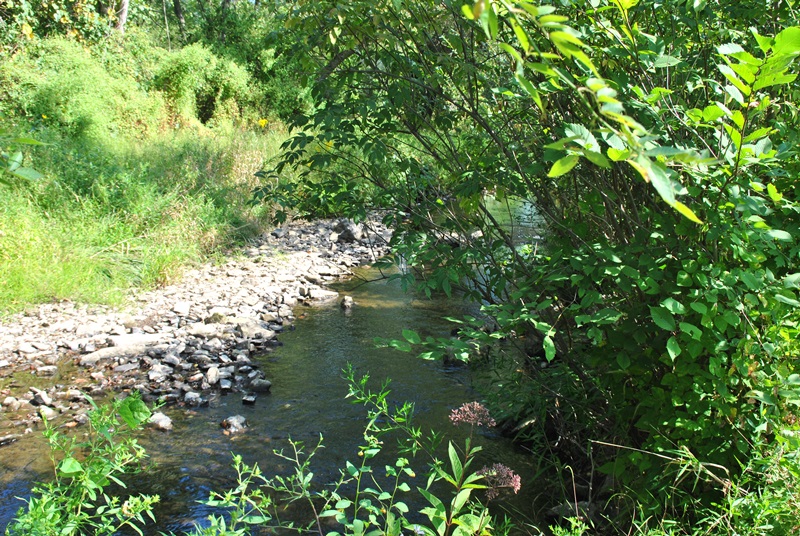
By now, I had turned back and was heading east alongside French Creek. There are a number of rock dams in the area which widened the creek.

Looking downstream again on French Creek with a fishing deck on the right side. There are a few nice fishing spots in this section of the creek.

 |
| View from the fishing deck looking downstream. |
Both the creek and the trail turn to the north, then back to the east again. Much of this portion of the hike was in full sunlight which on a hot day can be pretty toasty.


Back alongside French Creek again. Under normal conditions, I'm not sure it would have been possible but instead of circling back to the parking lot which I had intended on doing, I crossed over the rock dam and hit the trails on the opposite side. There hadn't been much rain recently so the creek was below normal levels.

Once I crossed over the creek, I turned back to the west. There's a nice overlook of French Creek but the view is blocked by trees and not picture-worthy. This was about the area where I had checked my phone to make sure it was tracking my progress and mistakenly paused the tracking app.


Eventually, the trail turned towards the northeast in the direction of one of the parking lots that are alongside Ridge Road (State Route 23).

In this area, you're cutting through some more open grassland and a mix of wooded areas.


This is the north access for the park, as if this isn't obvious. The parking lot is pretty small but in all the times I've driven past it, I don't think I've ever seen it full.

 |
| North access parking lot |
 |
| From the parking lot, I headed directly south. |

Once the trail turns to the east, you'll be hiking through more open fields for the time being.

Throughout Warwick County Park, there are a number of ruins but this was the only one I was able to find. Perhaps I may return in the winter to see if the others are more visible.


The rest of the hike on the northern side of Warwick County Park heads in a east/west direction and is relatively flat and straight. I was still hiking to the east.


This I found to be interesting. Over my last few hikes, I've seen this a number of times. In the middle of the trails, there were earthworms everywhere. Had I wanted to go fishing, I would have had an endless supply of bait!

A few weeks ago, I noticed these patterns in the dirt along the trails but had no idea where they had come from since I didn't see any earthworms. After seeing the earthworms all over the place, I think it's safe to say I figured it out.


Somewhere along this trail, there's supposed to be a turn-off trail that will take you alongside French Creek. I had intentions of checking this trail out but I either missed the turn or the trail isn't being maintained anymore.


The trail on the north side of Warwick County Park comes to an end at the Mt. Pleasant Road parking lot.

I followed Mt. Pleasant Road south, crossing over French Creek until I reached the Horse-Shoe Trail on the opposite side, then turned back to the west. I didn't take many pictures in the this area since I had already been through there when I hiked the Horse-Shoe Trail from St. Peters Village to Welkinweir.


The Horse-Shoe Trail turns to the southwest and intersects with the Charcoal Trail which makes a turn to the east and was the trail I followed.

This was the first real challenge of this hike. While it wasn't too steep, this hill was good enough to get the blood pumping.

The Charcoal Trail also intersects with another unnamed trail (maybe) and continues to the east to an open field.

I'm not sure what Sky's Loop is and can't find any information about it on the internet so I may return to find out. This sign was next to the side trail I was on, just on the edge of an open field. I had taken a picture of the field but unfortunately, with the sun being as bright as it was, the picture ended up being overexposed.

The side trail to this "Sky's Loop" was relatively short so I turned back to the Charcoal Trail which by now was headed in a southwest direction.


This is another side trail that led to the south access gate on Mt. Pleasant Road somewhere in here.

 |
| No parking here though |
 |
| Back to the Charcoal Trail, now heading west |
 |
| Although I didn't pay them much mind, there are mile markers on these trails. |
The Charcoal Trail splits off in two directions with one heading north leading back to the Horse-Shoe Trail and the other continuing to the west which was the direction I kept going.


There were a lot of rocks alongside this section of the Charcoal Trail.


 |
| Garter snake hanging out next to the trail |
 |
| IHT represents the Iron Heritage Trail |
Within this area, there's a lot of historical references to the iron industry and one of my reasons for wanting to return to Warwick County Park. I don't need a reason, if there's a trail, I want to check it out! They're not in any particular order but they explain the process of making charcoal for the local iron forges that were in the area at the time. Note that the information I obtained was taken from the signs scattered throughout this section of the park.
Southeastern Pennsylvania produced the most iron in the colonies and nation just before and after the Revolutionary War. Approximately 27,000 tons of iron was produced in 1810 which took approximately 4,100 acres of wood processed into charcoal.
During the fall and depending on demand, up to 350 acres of land were selected for cutting on an annual basis which would supply up to 5,000 cords of wood. Plots of trees were selected and cut in a checkerboard pattern to avoid clear cutting and to allow for new growth.
An acre of timber would yield approximately 30 cords of wood which in turn would produce about 1,200 bushels of charcoal. The 1,200 bushels of charcoal would produce approximately 6 2/3 tons of pig iron.
If you check out the above numbers, the math doesn't add up. According to the information provided on the signs, an acre of timber would produce approximately 30 cords of wood and 350 acres produced 5,000 cords. If you do the math, 30 cords per acre of wood and 350 acres is 10,500 cords. Obviously, one would need to take into account that trees are never the same size but that's a pretty big difference in numbers.


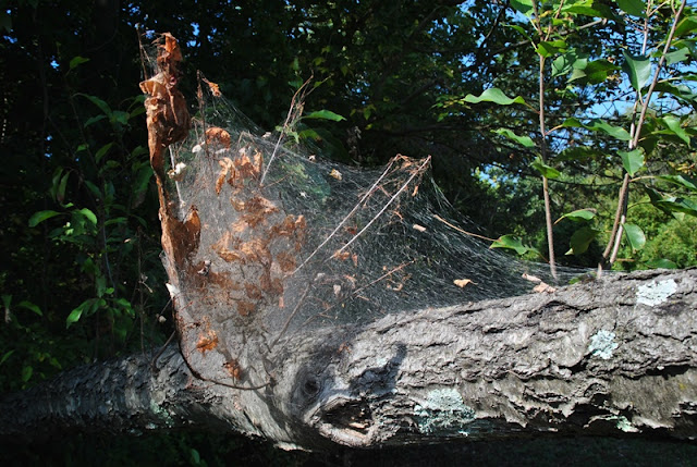
 |
| More of this funky white fungus or spider webs |

This is one of the numerous charcoal hearths scattered throughout the park as well as the many that you'll find throughout the entire area. Over the last few weeks, I've hiked at a few places (Coventry Woods Preserve, Woody's Woods) in the vicinity, each of which have had charcoal hearths.
I mentioned this in my post about Woody's Woods but if you don't know they exist, you may end up walking right past the remnants of a hearth without even realizing it's there. This makes me wonder how many I may have walked past in my previous adventures in the area before knowing what they were (French Creek State Park, Crow's Nest Preserve, Birdsboro Waters and Preserve, St. Peters Village). More detailed information about what a hearth is will be below.

During the winter, wood was usually cut and allowed to dry before operations began in late spring. The "woodchoppers" and "jack fellers" would cut the trees down, then "woodhaulers" would drag the trees to a clearing where "sawyers" processed them into four foot lengths.
There were two different sizes of wood which were referred to as "lap-wood" (smaller pieces like branches), and "billets" (trunks of trees). The cords of wood were separated by upright poles in order to allow for counting.

While taking a trip into history, I was still heading to the west on the Charcoal Trail/Iron Heritage Trail.

In the spring, a "collier" who was among the most skilled of the iron workers would prepare a suitable spot in the forest to build a hearth. It would have to be level, dry and protected from the wind (as well as being close to a wood pile). Their experience was required for knowing how to properly build, maintain, and recognize the various stages of creating charcoal including the color and smell of the mound (hearth) while burning.
I've already shown a few pictures of hearths over the last few weeks which don't look like much more than a flat space about 30-40 feet in diameter. A space used for creating a hearth had to be clear of trees, brush, roots, stumps, and any animal burrows were filled in to prevent oxygen from getting into the hearth during the burn.

Charcoal was produced during the summer months. In the center of the hearth, an internal chimney approximately 6-8 feet tall was built and in the center of that was a 10-15 foot pole known as a "fagan". Once the chimney was built, the collier and "charcoal helpers" packed billets against the chimney together as tightly a possible to avoid air pockets.
Additional layers were then stacked on top of the first layer until the mound was about 25 feet in diameter. Once this was completed, the next steps were to cover the wood pile with leaves and then dry soil. With the exception of a few carefully placed vent holes, the mound was air tight creating a self-made kiln.
At regular intervals, embers were dropped through a "clamp" on the top of the pile until they were red hot. Once this happened, the clamp was sealed. After 10 or so days, the collier would poke the fagan through the vent holes and if the "chingle" of finished coal was heard, the hearth was slowly opened which would occur over a number of days as the pile slowly cooled.
Once this process was completed, bushel baskets were filled with the charcoal and placed on a wagon where it was "teamed" (transported) to the furnaces.

A collier was the second highest paid worker of the iron industry next to the furnacemen. With that, the colliers job was to monitor the hearths 24 hours a day for blue smoke during the day and burning embers at night. If any air was to get into the hearth during the charcoal making process, the wood would burn to ash making it useless.
During the burn, the collier would live in a hut close to the hearths so that they could monitor them regularly.

The Fink Truss "bridge to nowhere" used to cross French Creek at one time but has since been moved to where it currently sits now, south of the main parking lot.

In the 1700's and 1800's, more than a dozen iron plantations were established in northern Chester County. The products created at the plantations were used throughout the country and the world.
Developed by Samuel Reeves, the Phoenix Column which was developed at the Northern Chester County Phoenix Iron Works, provided the skeletal framework for the Washington Monument in 1848 and the Eiffel Tower in 1889.
Iron also played a critical role in the American Revolution, the War of 1812 and the Civil War. From 1776-1777 approximately 100 "great guns" were cast at Hopewell Furnace. Iron was also used to cast stoves and hollow ware such as pots and kettles.
Due to the iron industry, the many trails you'll see throughout Chester County connected the hearths, forges and furnaces by the 1800's with one of those trails being the Horse-Shoe Trail.
To take note of this, I noticed these trails during my recent adventures throughout this part of Chester County were about the width of a single vehicle and thought that this might have been the reason for them. Reading about it confirms what my thoughts were.


Once I passed the Fink Truss bridge, I continued heading west until I reached a bench at the top of a hill to the southwest of the main parking lot and took a quick break. While I was at the bench and since the view from the top of this small hill is pretty nice, I decided to experiment with a function on one of my cameras that takes panoramic pictures.
Unfortunately, my picture experiment didn't turn out like I had hoped. The panoramic function of this camera requires taking more than one picture which then gets stitched together automatically. Keeping the camera at the same angle isn't as easy as it looks! If you look in the center of this picture, you can see in the tree line and field that I dipped my camera which makes it look like everything is caving into the middle. It's an ok picture but the dip isn't supposed to be there!

Directly behind the bench, you'll find an unmarked trail which I decided to check out. Like the rest of the trails in this area, they look like they used to be the old roadways between the hearths, etc., only overgrown since they're not being maintained.

 |
| I'm not sure what this was supposed to be at one time |
While walking through the woods in this area, you can see remnants of these trails heading in different directions, one of which led back towards County Park Road and another leading up a hill towards the southwestern section of the park. I didn't get very far after turning back though, The trails are there but they're overgrown.


After checking out the unmarked trails and looping past the main parking lot, I was heading east back into the woods on the Adirondack Tree ID and Iron Heritage Trails. I wasn't interested in identifying the trees though!

Ready for some more history? During the 1700's and early 1800's, charcoal and water power were sources of commerce, including the iron industry. The hardwood forests of Pennsylvania and the fast moving creeks in the area provided the fuel and drove the machinery needed for creating and refining pig iron into essential tools, building materials and utensils needed to build the new country.
As early as 1681, William Penn had taken note that the country was thought to be capable of producing iron as one of its commodities. After being settled by Penn in 1682, Chester County became a center for iron production.
In 1717, Coventry Forge was built and was one of the earliest forges established in the colonies. In all, 22 documented furnaces were built alongside the many streams and creeks in southeastern Pennsylvania.

I entered back into the woods heading east on the Adirondack/Iron Heritage Trail.


This is a bat house but I didn't see any bats in there. If you look at the floor however, you can tell they were. The dark spots on the floor of the bat house is bat droppings, known as guano.

Before you reach the above bat house, the Adirondack/Iron Heritage trail cuts to the southwest. Once you pass the bat house, there's another trail which according to the map is also part of the tree identification but is not being maintained. Being curious, I took the less beaten path and checked it out.


Back to a little more history. If I haven't lost you yet, it's almost over! Charcoal is a fuel that burns hotter than wood and is the result of heat eliminating the oxygen and hydrogen from it through a slow baking process (charcoal hearths). It is used for smelting iron from its ore in a blast furnace. Iron production began around 1300 B.C.
The hardwoods found in Pennsylvania produced the highest quality and quantity of charcoal to fuel the ironworks and the area around Warwick County park provided the wood and land needed to build the hearths to make charcoal.

By now, I was headed south on the Iron Heritage Trail, back towards the Horse-Shoe Trail.


This sign is a basic overview of what happened throughout each season with the charcoal production process which has already been explained. If you have further interest in the iron making industry in Pennsylvania, check out this page on the Explore PA History website.

Back to the trails! Eventually, the Iron Heritage Trail led me back to the Horse-Shoe Trail which I followed heading south, then back to the west until I reached the main parking lot of Warwick County Park.


Once out to the parking lot, I cut behind one of the pavilions and found another trail that unfortunately led me to a dead end.

I hiked past the parking lot for the time being and covered a portion of trail (Red Cliff Trail) that I hadn't been on earlier in the day. Eventually, it brought me back to where I had crossed over French Creek when I first started my hike.

 |
| I took another shot of the area where I had crossed over earlier in the day |
 |
| Headed back to the parking lot! |
That was it for my adventure through history and Warwick County Park. In all, it was an excellent hike and one that I'd eventually like to return to. The trails are in very good condition, if not excellent, are well maintained with the exception of one, and of course there's the history of the iron industry as well as the Horse-Shoe Trail. My only word of "caution" would be to make sure you put on some sunscreen if you decide to go there on a sunny day since there are a number of trails that are in full sunlight, especially the western and northern sides of the park.
Until next time, happy exploring and happy hiking!
Please give my Facebook page a like!
No comments:
Post a Comment