This post is two hikes in one, both of which are alongside different sections of Pickering Creek in Chester County with the first being the River Birch Trail.
Date of Hike: May 10, 2015
Date of Hike: May 10, 2015
Total Distance: 0.56 Miles
Avg speed: 1.43 MPH
Avg moving speed: 1.61 MPH
Moving Time: 20:49
Total Time: 23:20
Conditions: Sunny, 82 Degrees
Difficulty: Easy
Before I get started, this is not by any means a slight on the volunteers who dedicated their time to build this trail (or any others for that matter). I have nothing but respect for those who put hours of effort into building and maintaining these trails for those of us who use them for recreation.
With that being said, this was a very short hike and a disappointment. I had spotted this trail a few weeks ago when I took a tour of the Binky Lee Preserve and had it marked to return to someday. That day was this past Sunday and as it turns out, it didn't prove to be worth the gas to drive there. I always enjoy exploring and thankfully, I was at Historic Yellow Springs no more than a mile or so away so it wasn't a complete waste of time. Had I known how short this hike was going to be, I would have checked it out during my exploration of Binky Lee Preserve.
Approximate address:
1542 Pikeland Rd
Chester Springs, PA 19425
GPS: 40.100147,-75.6107895
As usual, Google Maps isn't entirely accurate here but it's pretty darn close this time. When you arrive at this address, you'll see a small dirt parking lot a very short distance to the west of Pickering Creek. If you want to add some distance to this hike, there's the Bridge to Bridge trail (see my post about the Binky Lee Preserve) that runs north alongside the Pickering Creek and the Binky Lee Preserve about a quarter mile or so east on Pikeland Road.

The trail head is on the southeast side of Pickering Creek so I had to cross over Pikeland Road and the bridge to get to it.
.JPG)
I made mention of Pickering Grove when I mentioned this trail in my post about the Binky Lee Preserve and have discovered that it's a small park on the opposite side of Pickering Creek
.JPG)
.JPG)
About 40-50 feet in, you'll see a kiosk station with this small trail map. As you can see, the trail basically leads to nowhere which was why I was disappointed. I was hoping there would be either a bridge to cross over or that the water was shallow enough to walk across but no dice on either. The water is shallow enough, but I was thinking more in the lines of less than ankle deep. The map also shows a fallen tree across the creek but it's no longer there.
.JPG)
.JPG)
.JPG)
.JPG)
Directly in front of me was a drop of a few feet down to the creek. This section is titled "Down by the Water's Edge" on the map.
.JPG)
.JPG)
I doubled back and followed the sign for the trail to turn to the east and followed about as far as I could go. I was still wearing my shorts and as you can tell, this trail is not as well maintained as some of the others that run alongside the Pickering Creek. There are some more trails in the area but they look to be deer trails (I also noted a few tree stands) which I tried to follow for a distance but ended up turning back after getting to overgrown areas.
.JPG)
Back to the edge of the water, I took pictures of Pickering Creek looking downstream and upstream. If you look across the creek, you can see some sort of pavilion looking building which would have been interesting. From what I found out, the place across the creek is called Miss Betty's Day Camp.
.JPG)
.JPG)
After shooting pictures of the creek, I was on my way back to the car. I had hoped that there would be more trails but that wasn't the case.
.JPG)
.JPG)
.JPG)
.JPG)
.JPG)
That was it for my hike on the River Birch Trail. I hope there are plans in the works to extend it further. The second half of this adventure hiking alongside the Pickering Creek was far better than this which you'll see in a moment. I hope to eventually see some connecting trails to make this one large trail similar to the Schuylkill River Trail, only unpaved.
Part two of the Pickering Creek trails was to check out what's called the Ice Dam Trail.
Difficulty: Easy, Moderate
*This is the second time my GPS app decided not to function properly in the last few months. My average speeds and times I hiked were the same which is impossible when you're stopping to take pictures. Hopefully this trend doesn't continue.
Approximate address:
4450 State Rd (Route 29)
Phoenixville, PA 19460
40.101297, -75.536512
It's becoming more and more usual to find that Google Maps isn't as accurate as I had thought. The 4450 address will get you there but will also put you in the middle of the creek downstream and south of State Road. The GPS coordinates are about as accurate as I could get them. When you arrive at the trail head, you won't be able to miss the ice dam, it's pretty large. Parking is just west of the ice dam.
To obtain a copy of the trail map, click here. You likely won't get lost but it's better to have the map and not take that chance. There are more trails than what's shown on the map which you'll see further down.

The Pickering Ice Dam was built in 1900. While in use, ice was harvested during the winter from the 30 acre pond that was created when it was dammed. In 1906 the Knickerbocker Ice Company bought the pond and cut the ice during the colder months of winter where it was stored in an ice house until summer. Nearby, there was a rail line (Phoenixville Branch) that was used to ship the ice to Philadelphia and the Main Line.
The ice plant was closed in 1920 due to lack of business and in 1926, Frank Foster bought the pond and used it as a recreation area which he named Walden Pond. A flood destroyed the dam in 1942 and was never rebuilt. In 1983, Charlestown Township acquired the land from the Foster, Stonorov, Churchill family as part of an open space tract along the Pickering Creek.
.JPG)
.JPG)
.JPG)
.JPG)
View looking across the Pickering Creek. If you look closely in the center of this picture, you can see the other side of the remains of the ice dam.
.JPG)
Looking back to State Road (Route 29) and also a shot of a trail marker.
.JPG)
The trail leads west alongside Pickering Creek next to the remains of the dam. Here's a better shot of the remains on the opposite side of the creek.
.JPG)
The trail in this area is in pretty decent shape and was well marked with white trail markers.
.JPG)
.JPG)
.JPG)
.JPG)
.JPG)
.JPG)
A little further up, the Ice Dam Trail will lead you to Pickering Dam Road and over a small creek.
.JPG)
The trail crosses over the Pickering Creek in this area.
.JPG)
.JPG)
These are the remains of a bridge that once carried rail cars loaded with ice across the creek and connected to the Phoenixville Branch railroad. If you're driving on State Road (State Route 29), you'll see the trestle crossing over that was part of this now abandoned railroad. Behind me to my right was the trail crossing over Pickering Creek.
.JPG)
.JPG)
I wasn't able to get a picture looking downstream since there was a fisherman in the water at the time. I had meant to take one on my return but forgot to.
.JPG)
Once you cross over the bridge, the trail continues to the west and is in much better condition than what's on the opposite side (the opposite side was pretty good too but this is real nice).
.JPG)
.JPG)
My only issue was that it didn't stay close to the Pickering Creek creek in places due to it being dammed so many years ago. Technically, there are two trails in one here. The Pickering Ice Dam Trail was built in 2014 as an Eagle Scout project and the original Pickering Trail (after crossing over Pickering Creek, it turns into the Pickering Trail) has been part of Charlestown Township for more than 10 years.
.JPG)
.JPG)
.JPG)
.JPG)
.JPG)
If you enjoy fishing like I do, this section of Pickering Creek has some pretty nice spots to throw your line into the water.
.JPG)
Old wooden and chain fence. My guess is that at one time it was built to keep people from falling down the bank but even then, it wasn't that tall.
.JPG)
.JPG)
Remains of what might have been a dam of some sort although I don't know for sure.
.JPG)
.JPG)
This was just about the end of the Pickering Dam Trail. As you walk up the steps, you end up in someone's driveway which will lead you out to Charlestown Road.
.JPG)
.JPG)
.JPG)
From the driveway, you won't be able to miss the trail head if you decide to park on Charlestown Road. Just to the left edge of this trail head sign, you can see another sign that states "no trespassing" (or something along those lines) and a gate.
.JPG)
Across the street on Charlestown Road is the Charlestown Mill. Built around 1724, this woolen mill was in operation for more than 170 years and produced goods made of wool (blankets, etc.) and cotton as well as the processing of flax and grain. In 1902, it was converted into a grist and cider mill, and later in the 1900's, it eventually became a garage and blacksmith shop.
Arnold Bartschi purchased the mill in 1963 with the intentions of preserving it (and the mill village around it). In 1978, Bartschi and the French and Pickering Creeks Conservation Trust placed the mill under conservation easement. In 2004, the mill which had been slowly falling apart, was restored. For more information about the mill, click here.
.JPG)
I circled around the back of the building to check it out. I peeked in the windows but I didn't take any pictures. I'm not sure if it's open to the public or not but I'd like to find out so I can get a better look inside.
.JPG)
Update: On September 2, 2015, I returned to the Pickering/Pickering Dam Trails for a quick hike and upon returning to the mill, the doors were open and a gentleman was working on restoring the interior of the building (I wish I could remember his name!) and was kind enough to allow me inside to take some pictures. Unfortunately, I don't have any knowledge about how any of the equipment worked or what they're called but it made for some pretty good pictures. Perhaps in time, I can find out and update accordingly. For now, enjoy the pictures!


I crossed back over Charlestown Road and headed down the driveway leading to the trail head.
.JPG)
.JPG)
Since I had already been on this trail, I didn't take many pictures for a distance.
.JPG)
I took some better pictures of what used to be this chain and wooden fence. As you can see, it's been there a while.
.JPG)
.JPG)
.JPG)
Approaching the bridge that crosses over the Pickering Creek. At this point, I could have returned to my vehicle but instead, there are trails that lead northward away from the creek on the same side that I decided to check out.
.JPG)
.JPG)
.JPG)
.JPG)
I thought about going back the way I came but am glad I didn't. As you get a little further down the trail, you'll run into these ruins which are the remains of an office building for the Ice Company when it was in operation. Sadly, someone decided to leave their signature on one of the inside walls.
.JPG)
.JPG)
.JPG)
.JPG)
.JPG)
Somewhere along my journey, I found another intersection of trails, most of which were leading away from where my car was so I took the trail I thought would bring me closest. After heading north for a distance, I turned on a trail that was heading to the east.
.JPG)
.JPG)
Gradually, the trail turned back to the north, away from my car. I had considered turning around a few times but figured I'd eventually find my way out.
.JPG)
.JPG)
.JPG)
.JPG)
.JPG)
I found my way out but ended up in a development (Charlestown Hunt) and had to walk along the road the rest of the way back to my car.
.JPG)
The road out of the development took me alongside the woods where I spotted a few deer, one of which I didn't notice until it took off. The below pictures are of the same deer. When it saw me, it took off running in the direction I was walking so I caught up to it again and managed to get another picture.
.JPG)
.JPG)
In case you ever decide to hike these trails, be advised that State Road (State Route 29) can be busy at times. There's enough room to walk on the side of the road but use caution anyway. Even though there was plenty of room, cars won't slow down when they see you.
From the State Road bridge crossing over the Pickering Creek, I took a few last shots and called it a day.
.JPG)
.JPG)
Before I get started, this is not by any means a slight on the volunteers who dedicated their time to build this trail (or any others for that matter). I have nothing but respect for those who put hours of effort into building and maintaining these trails for those of us who use them for recreation.
With that being said, this was a very short hike and a disappointment. I had spotted this trail a few weeks ago when I took a tour of the Binky Lee Preserve and had it marked to return to someday. That day was this past Sunday and as it turns out, it didn't prove to be worth the gas to drive there. I always enjoy exploring and thankfully, I was at Historic Yellow Springs no more than a mile or so away so it wasn't a complete waste of time. Had I known how short this hike was going to be, I would have checked it out during my exploration of Binky Lee Preserve.
Approximate address:
1542 Pikeland Rd
Chester Springs, PA 19425
GPS: 40.100147,-75.6107895
As usual, Google Maps isn't entirely accurate here but it's pretty darn close this time. When you arrive at this address, you'll see a small dirt parking lot a very short distance to the west of Pickering Creek. If you want to add some distance to this hike, there's the Bridge to Bridge trail (see my post about the Binky Lee Preserve) that runs north alongside the Pickering Creek and the Binky Lee Preserve about a quarter mile or so east on Pikeland Road.

The trail head is on the southeast side of Pickering Creek so I had to cross over Pikeland Road and the bridge to get to it.
.JPG)
.JPG) |
| View of Pickering Creek from the bridge looking upstream |
.JPG) |
| Trail head marker |
I made mention of Pickering Grove when I mentioned this trail in my post about the Binky Lee Preserve and have discovered that it's a small park on the opposite side of Pickering Creek
.JPG)
.JPG)
About 40-50 feet in, you'll see a kiosk station with this small trail map. As you can see, the trail basically leads to nowhere which was why I was disappointed. I was hoping there would be either a bridge to cross over or that the water was shallow enough to walk across but no dice on either. The water is shallow enough, but I was thinking more in the lines of less than ankle deep. The map also shows a fallen tree across the creek but it's no longer there.
.JPG)
.JPG)
.JPG)
.JPG)
Directly in front of me was a drop of a few feet down to the creek. This section is titled "Down by the Water's Edge" on the map.
.JPG)
.JPG)
I doubled back and followed the sign for the trail to turn to the east and followed about as far as I could go. I was still wearing my shorts and as you can tell, this trail is not as well maintained as some of the others that run alongside the Pickering Creek. There are some more trails in the area but they look to be deer trails (I also noted a few tree stands) which I tried to follow for a distance but ended up turning back after getting to overgrown areas.
.JPG)
Back to the edge of the water, I took pictures of Pickering Creek looking downstream and upstream. If you look across the creek, you can see some sort of pavilion looking building which would have been interesting. From what I found out, the place across the creek is called Miss Betty's Day Camp.
.JPG)
.JPG)
After shooting pictures of the creek, I was on my way back to the car. I had hoped that there would be more trails but that wasn't the case.
.JPG)
.JPG)
.JPG)
.JPG)
.JPG)
.JPG) |
| Almost back to Pikeland Road |
That was it for my hike on the River Birch Trail. I hope there are plans in the works to extend it further. The second half of this adventure hiking alongside the Pickering Creek was far better than this which you'll see in a moment. I hope to eventually see some connecting trails to make this one large trail similar to the Schuylkill River Trail, only unpaved.
Part two of the Pickering Creek trails was to check out what's called the Ice Dam Trail.
Total Distance: 3.88 Miles
Avg speed: 2.24 MPH*
Total Time:1:44:03*
*This is the second time my GPS app decided not to function properly in the last few months. My average speeds and times I hiked were the same which is impossible when you're stopping to take pictures. Hopefully this trend doesn't continue.
Approximate address:
4450 State Rd (Route 29)
Phoenixville, PA 19460
40.101297, -75.536512
It's becoming more and more usual to find that Google Maps isn't as accurate as I had thought. The 4450 address will get you there but will also put you in the middle of the creek downstream and south of State Road. The GPS coordinates are about as accurate as I could get them. When you arrive at the trail head, you won't be able to miss the ice dam, it's pretty large. Parking is just west of the ice dam.
To obtain a copy of the trail map, click here. You likely won't get lost but it's better to have the map and not take that chance. There are more trails than what's shown on the map which you'll see further down.

The Pickering Ice Dam was built in 1900. While in use, ice was harvested during the winter from the 30 acre pond that was created when it was dammed. In 1906 the Knickerbocker Ice Company bought the pond and cut the ice during the colder months of winter where it was stored in an ice house until summer. Nearby, there was a rail line (Phoenixville Branch) that was used to ship the ice to Philadelphia and the Main Line.
The ice plant was closed in 1920 due to lack of business and in 1926, Frank Foster bought the pond and used it as a recreation area which he named Walden Pond. A flood destroyed the dam in 1942 and was never rebuilt. In 1983, Charlestown Township acquired the land from the Foster, Stonorov, Churchill family as part of an open space tract along the Pickering Creek.
.JPG)
.JPG)
.JPG)
.JPG)
View looking across the Pickering Creek. If you look closely in the center of this picture, you can see the other side of the remains of the ice dam.
.JPG)
Looking back to State Road (Route 29) and also a shot of a trail marker.
.JPG)
The trail leads west alongside Pickering Creek next to the remains of the dam. Here's a better shot of the remains on the opposite side of the creek.
.JPG)
The trail in this area is in pretty decent shape and was well marked with white trail markers.
.JPG)
.JPG)
.JPG)
.JPG)
.JPG) |
| Lots of mushrooms (or fungus) this time of year, or so it seems |
.JPG) |
| Family of geese across the creek from me |
.JPG)
.JPG)
A little further up, the Ice Dam Trail will lead you to Pickering Dam Road and over a small creek.
.JPG)
The trail crosses over the Pickering Creek in this area.
.JPG)
.JPG)
.JPG) |
| Another trail leading to Pickering Dam Road |
These are the remains of a bridge that once carried rail cars loaded with ice across the creek and connected to the Phoenixville Branch railroad. If you're driving on State Road (State Route 29), you'll see the trestle crossing over that was part of this now abandoned railroad. Behind me to my right was the trail crossing over Pickering Creek.
.JPG)
.JPG)
.JPG) |
| View looking upstream from the bridge |
I wasn't able to get a picture looking downstream since there was a fisherman in the water at the time. I had meant to take one on my return but forgot to.
.JPG)
Once you cross over the bridge, the trail continues to the west and is in much better condition than what's on the opposite side (the opposite side was pretty good too but this is real nice).
.JPG)
.JPG)
My only issue was that it didn't stay close to the Pickering Creek creek in places due to it being dammed so many years ago. Technically, there are two trails in one here. The Pickering Ice Dam Trail was built in 2014 as an Eagle Scout project and the original Pickering Trail (after crossing over Pickering Creek, it turns into the Pickering Trail) has been part of Charlestown Township for more than 10 years.
.JPG)
.JPG)
.JPG)
.JPG)
.JPG)
If you enjoy fishing like I do, this section of Pickering Creek has some pretty nice spots to throw your line into the water.
.JPG)
Old wooden and chain fence. My guess is that at one time it was built to keep people from falling down the bank but even then, it wasn't that tall.
.JPG)
.JPG)
.JPG) |
| This is a bench that was built from the remains of a tree that had fallen. |
Remains of what might have been a dam of some sort although I don't know for sure.
.JPG)
.JPG)
This was just about the end of the Pickering Dam Trail. As you walk up the steps, you end up in someone's driveway which will lead you out to Charlestown Road.
.JPG)
.JPG)
.JPG)
From the driveway, you won't be able to miss the trail head if you decide to park on Charlestown Road. Just to the left edge of this trail head sign, you can see another sign that states "no trespassing" (or something along those lines) and a gate.
.JPG)
Across the street on Charlestown Road is the Charlestown Mill. Built around 1724, this woolen mill was in operation for more than 170 years and produced goods made of wool (blankets, etc.) and cotton as well as the processing of flax and grain. In 1902, it was converted into a grist and cider mill, and later in the 1900's, it eventually became a garage and blacksmith shop.
Arnold Bartschi purchased the mill in 1963 with the intentions of preserving it (and the mill village around it). In 1978, Bartschi and the French and Pickering Creeks Conservation Trust placed the mill under conservation easement. In 2004, the mill which had been slowly falling apart, was restored. For more information about the mill, click here.
.JPG)
I circled around the back of the building to check it out. I peeked in the windows but I didn't take any pictures. I'm not sure if it's open to the public or not but I'd like to find out so I can get a better look inside.
.JPG)
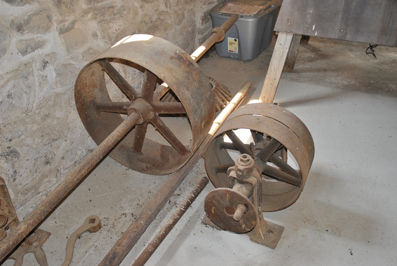
Update: On September 2, 2015, I returned to the Pickering/Pickering Dam Trails for a quick hike and upon returning to the mill, the doors were open and a gentleman was working on restoring the interior of the building (I wish I could remember his name!) and was kind enough to allow me inside to take some pictures. Unfortunately, I don't have any knowledge about how any of the equipment worked or what they're called but it made for some pretty good pictures. Perhaps in time, I can find out and update accordingly. For now, enjoy the pictures!


.JPG) |
| View looking back to the Charlestown Mill |
I crossed back over Charlestown Road and headed down the driveway leading to the trail head.
.JPG)
.JPG)
Since I had already been on this trail, I didn't take many pictures for a distance.
.JPG)
I took some better pictures of what used to be this chain and wooden fence. As you can see, it's been there a while.
.JPG)
.JPG)
.JPG)
Approaching the bridge that crosses over the Pickering Creek. At this point, I could have returned to my vehicle but instead, there are trails that lead northward away from the creek on the same side that I decided to check out.
.JPG)
.JPG)
.JPG)
.JPG)
I thought about going back the way I came but am glad I didn't. As you get a little further down the trail, you'll run into these ruins which are the remains of an office building for the Ice Company when it was in operation. Sadly, someone decided to leave their signature on one of the inside walls.
.JPG)
.JPG)
.JPG)
.JPG)
.JPG)
Somewhere along my journey, I found another intersection of trails, most of which were leading away from where my car was so I took the trail I thought would bring me closest. After heading north for a distance, I turned on a trail that was heading to the east.
.JPG)
.JPG)
Gradually, the trail turned back to the north, away from my car. I had considered turning around a few times but figured I'd eventually find my way out.
.JPG)
.JPG)
.JPG)
.JPG)
.JPG)
I found my way out but ended up in a development (Charlestown Hunt) and had to walk along the road the rest of the way back to my car.
.JPG)
.JPG) |
| One last look back to the trail before heading out of the development |
The road out of the development took me alongside the woods where I spotted a few deer, one of which I didn't notice until it took off. The below pictures are of the same deer. When it saw me, it took off running in the direction I was walking so I caught up to it again and managed to get another picture.
.JPG)
.JPG)
In case you ever decide to hike these trails, be advised that State Road (State Route 29) can be busy at times. There's enough room to walk on the side of the road but use caution anyway. Even though there was plenty of room, cars won't slow down when they see you.
From the State Road bridge crossing over the Pickering Creek, I took a few last shots and called it a day.
.JPG)
.JPG)
In all, this section of Pickering Creek was very nice and well worth the trip to come out to have a look. I was also happy to find some additional trails (and ruins) that aren't mentioned anywhere as far as I know. It was a beautiful day for hiking and I look forward to returning to these trails again to see what else I can find along the way.
I'd like to thank Sue Staas, Chair of the Trails Committee in Charlestown Township for providing me with some insight on the history of not only these trails, but also the area surrounding it!
Until next time, happy adventures and happy hiking!
Please give my Facebook page a like!
No comments:
Post a Comment